Forecast for the Ogden Area Mountains

Evelyn Lees
Issued by Evelyn Lees for
Saturday, March 16, 2019
The avalanche danger is LOW early this morning, but will rapidly increase to MODERATE for Wet Snow avalanches in almost all steep backcountry terrain.
Travel advice is straight forward: when the snow becomes damp or wet where you are, get off of and out from under steep slopes. Wet sluffs that can carry and bury a person will be easy to trigger and natural avalanches will occur. Head to low angle terrain and avoid run out zones like the bottom of gullies.
On upper elevation, shady slopes isolated shallow soft slab avalanches and sluffs can be triggered, serious in steep terrain.
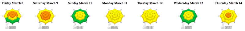
Low
Moderate
Considerable
High
Extreme
Learn how to read the forecast here
Special Announcements
The latest podcast is out! The Wise Ones - A Conversation About Mentorship with Eeva Latosuo and Aleph Johnston-Bloom. LINK
Catch up on the past week's snow and avalanche activity with Greg’s Week in Review. Check it out here.
Weather and Snow
The switch flipped, and spring is here - yesterday’s high-angle sun destroyed the powder on all but the steeper, shady upper elevation slopes, above about 7,500’. Elsewhere, you will find supportable and breakable crusts early, that will melt into sloppy, wet snow as the day heats up.
This morning, under clear skies, temperatures are in the twenties at the mid and upper elevations in the Ogden area mountains, about 10 degrees warmer than yesterday morning. Where the cold air has pooled in the canyon bottoms, there are even a few teens. Highs today will be near 40 at 7,500’ and the upper 20s along the highest ridge lines. A true rarity, even on Mount Ogden, winds are amazingly calm, and should remain that way through the day. The next chance for snow isn’t until mid week.
"Northerly aspect should still ski like winter tomorrow AM". Dan Morris photo, Ben Lomond.
Recent Avalanches
Yesterday, the Ogden area resorts were able to release small soft slabs and wind slabs with explosives along the high ridge lines. There were several skier triggered slides in the backcountry around Snowbasin, with no one caught.
Ad
Avalanche Problem #1
Wet Snow
Type
Location
Likelihood
Size
Description
With wet snow, it’s a balance - the initial shock of sun and heating on the dry, cold snow is over, so normally wet loose avalanche activity would decrease. But today’s 10 to 15 degree head start on heating will keep wet snow active.
Today’s Wet Snow avalanche activity is PREDICTABLE and AVOIDABLE. As the day heats and the sun hits the slopes, it’s guaranteed the snow become wet, loose and sloppy. You will be able to triggered wet loose sluffs on steep slopes and some natural wet snow avalanches will occur.
Avoidance: when the snow becomes wet, move off steep slopes to lower angle terrain. Be aware of what is above you, and avoid travel beneath steep slopes and gullies. Plan your exits carefully to avoid steep terrain at the mid and low elevations, especially gullies and drainages. Even small wet sluffs pack a punch, and can push you around or take you for a ride down slope or into trees. Start early and finish early.
With a multi-day “heat wave” in progress, roofs will shed their remaining snow and cornices will become more sensitive and avoid travel below glide cracks.
Avalanche Problem #2
Normal Caution
Type
Location
Likelihood
Size
Description
There is inherent risk in mountain travel - early in the morning, slide-for-life’s may be possible on the hard crusts. On steep, upper elevation northerly facing slopes, there is potential to trigger a shallow dry snow slabs and loose sluffs in isolated places. Exact terrain matters - even a small slide can have serious consequences in big, steep terrain or if you’re above cliffs.
Additional Information
Don’t forget your skin wax and scraper today!
General Announcements
This information does not apply to developed ski areas or highways where avalanche control is normally done. This forecast is from the U.S.D.A. Forest Service, which is solely responsible for its content. This forecast describes general avalanche conditions and local variations always occur.