Join us for the 33rd Backcountry Benefit - Get Your Tickets Now!

Forecast for the Ogden Area Mountains

Greg Gagne
Issued by Greg Gagne on
Monday morning, February 16, 2026

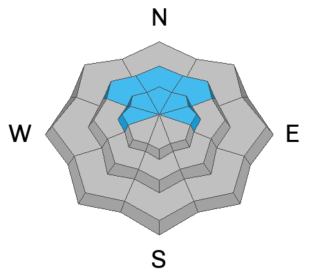
There is a MODERATE avalanche danger on mid and upper-elevation slopes facing northwest, north, and east - including upper-elevation slopes facing west - where it is possible to trigger an avalanche up to 18 inches deep and over a hundred feet wide, failing on a buried persistent weak layer. Slopes that are wind-loaded from strong winds blowing from the south/southwest are the most susceptible to avalanche.

The Utah Avalanche Center has issued an Avalanche Watch as heavy snowfall beginning this evening accompanied by strong winds will create dangerous avalanche conditions this week.

Low
Moderate
Considerable
High
Extreme
Learn how to read the forecast here
Avalanche Watch

What: Heavy snowfall and strong winds are expected to rapidly increase avalanche danger across northern and central Utah beginning Tuesday and continuing through the week. Forecasters at the Utah Avalanche Center expect dangerous and complex avalanche conditions to develop on many slopes, with large natural and human-triggered avalanches likely.

When: The Avalanche Watch is issued on Monday, 2/16/26 at 6:00 AM MST through 6:00 AM MST Tuesday, 2/17/26.

Where:
The Avalanche Watch is for the mountains of Northern, Central, and Southwestern Utah as well as Southeastern Idaho, including:

  • The Wasatch Range

  • The Bear River Range

  • The Western Uinta Mountains

  • The Wasatch Plateau

  • The Tushars

Impacts:

  • Dangerous avalanche conditions are expected to develop on many slopes.

  • Avalanches can be triggered on slopes steeper than 30 degrees. They may also be triggered remotely (from a distance) or from below.

What to do:

  • Avoid traveling on or underneath steep terrain at mid and upper elevations in the backcountry.

  • Carry and know how to use avalanche rescue equipment, including a transceiver, shovel, and probe.

  • Find safer riding conditions on slopes less than 30 degrees with no overhead hazard.

For updated avalanche information, visit www.utahavalanchecenter.org.

Special Announcements

Join the UAC for the first "Stay and Play Avalanche Course" at Bear River Lodge in the Uintas, March 19th-22nd. This course is designed for snowmobilers by snowmobilers, where you will learn avalanche rescue, riding skills, and how to survive in the backcountry. Come enjoy all the luxury offerings at Bear River Lodge and improve your skills along the way.

You can find details and sign up HERE.

Weather and Snow

6 am: Skies are partly cloudy and temperatures range from 25°-35° F. Winds are blowing from the south/southwest and strong, with gusts of 30-45 mph along exposed slopes and ridges at the mid and upper elevations.

Today: Skies will become mostly cloudy with temperatures in the upper 30's °F. Winds will increase throughout the day.

Tonight and into Tuesday: Strong winds, with gusts over 50 mph along exposed mid and upper-level ridges. Heavy snowfall overnight and into Tuesday, with 6-10 inches of new snow by late Tuesday.

Heavy snowfall is expected again Wednesday and Thursday, with snowfall totals of two to three feet by later Thursday.

Recent Avalanches

We received no observations from Sunday, but two reports from Saturday include

- Josh Martineau on Bountiful Peak

- Derek DeBruin on Cutler Ridge

Both Josh and Derek reported a poor snowpack structure of faceted snow.

You can view all recent observations here.

Avalanche Problem #1
Persistent Weak Layer
Type
Location
Likelihood
Size
Description

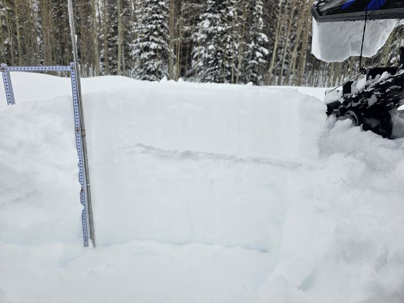
The January dry spell left a widespread persistent weak layer (PWL) of faceted snow northerly-facing slopes at the mid and upper elevations, including upper-elevation slopes facing west and east, and this layer is now buried underneath the 6-14 inches of snow from this past Wednesday. This PWL is evident in the gray stripe shown in the photo below from Kaufman near Monte Cristo on Friday . Watch UAC Director Paige Pagnucco's video under Additional Info (below) on how this PWL has developed.

Wind-loaded slopes are the most likely to avalanche on this PWL where the wind has created a stronger slab above this buried PWL.

This PWL structure will create dangerous avalanche conditions with heavy snowfall and strong winds beginning later today and lasting through much of this week.

Additional Information

Learn more about Persistent Weak Layers in the video above -

General Announcements

This information does not apply to developed ski areas or highways where avalanche control is normally done. This forecast is from the U.S.D.A. Forest Service, which is solely responsible for its content. This forecast describes general avalanche conditions and local variations always occur.