UDOT PLANNED AVALANCHE CLOSURES!!

Forecast for the Ogden Area Mountains

Trent Meisenheimer
Issued by Trent Meisenheimer for
Sunday, December 2, 2018
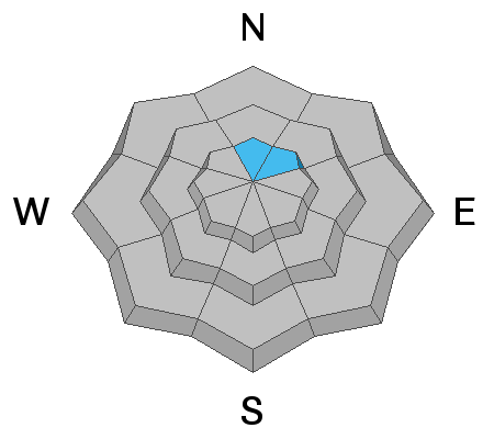
The avalanche hazard is MODERATE at the upper elevations on steep slopes facing north and northeast, where it is possible to trigger an avalanche that fails in old weak snow at the ground. Other steep slopes - across the upper elevations - have a MODERATE hazard for triggering a new snow slide or a wind drift. The avalanche danger is LOW at low & mid elevations. The dense snow has created excellent travel and riding conditions on low-angled slopes.
Low
Moderate
Considerable
High
Extreme
Learn how to read the forecast here
Special Announcements
Thanks to everyone who came out for the 2nd annual Ogden Backcountry Bash! All proceeds will go to support backcountry avalanche forecasting and education in the Ogden mountains.
Weather and Snow
It continues to be overcast with occasional light snow in the mountains as a weak cyclonic (counter clockwise) circulation sets up over the west dessert. Overnight totals are a trace to an inch of low density new snow. Winds will remain light and from the east this morning, before switching to the northwest by this evening as this weak circulation moves downstream (east). The good news: this will likely bring 2-4" of champagne blower powder today and keep the riding and turning conditions all time. Current mountain top temperatures are in the mid teens °F while the lower elevations sit just above 20°F. Upper elevation Ogden anemometers are currently spinning 5-10 mph.
Recent Avalanches
We have no reports from the backcountry. Snow safety teams reported stable snow yesterday.
Ad
Avalanche Problem #1
Persistent Weak Layer
Type
Location
Likelihood
Size
Description
The Ogden area mountains had minimal old snow on the ground prior to Thanksgiving, and there continues to be very limited evidence of basal facets. A few suspect areas are on upper elevation slopes facing N and NE. The storm snow and wind drifts from the past few days will test this potential weak layer, and we will have to see how it reacts. Obvious clues are recent avalanching, and collapsing and cracking.
Avalanche Problem #2
New Snow
Type
Location
Likelihood
Size
Description
With over 2 feet of new snow you can't rule out - new snow sluffs and new snow soft slabs. This problem tends to stabilize rapidly and is easy to manage. However, this morning we need to continue using safe travel protocol. Waves or pillows of snow, denser thick snow, or cracking are all signs of new snow instability.
General Announcements
This information does not apply to developed ski areas or highways where avalanche control is normally done. This advisory is from the U.S.D.A. Forest Service, which is solely responsible for its content. This advisory describes general avalanche conditions and local variations always occur.