UDOT PLANNED AVALANCHE CLOSURES!!

Forecast for the Ogden Area Mountains

Greg Gagne
Issued by Greg Gagne for
Monday, December 3, 2018
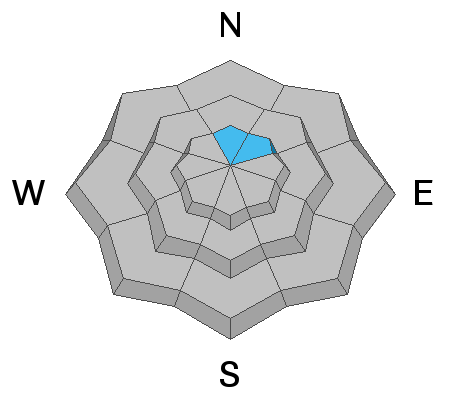
The avalanche hazard is MODERATE at the upper elevations on steep slopes facing north and northeast, where it is possible to trigger an avalanche that fails in old weak snow at the ground. Other steep slopes - across the upper elevations - have a MODERATE hazard for triggering sluffs in the recent storm snow, as well as small pockets of fresh wind drifts. The avalanche danger is LOW at low & mid elevations.
Low
Moderate
Considerable
High
Extreme
Learn how to read the forecast here
Special Announcements
Thanks to everyone who came out for the 2nd annual Ogden Backcountry Bash! All proceeds will go to support backcountry avalanche forecasting and education in the Ogden mountains.
Weather and Snow
Conditions this morning in the Ogden mountains include temperatures in the low to mid teens and light winds out of the west/northwest. Snow totals over the past 24 hours are 5", and snowpack depths are 2-3'. The recent storm snow has begun to fill in the mid and low elevation trailheads.
Skies will be mostly cloudy today with a chance for snow showers that may bring 1-3" of low-density snow. Mountain temperatures will range through the teens, and winds are forecasted to be out of the west/northwest and generally light, with gusts in the teens.
Recent Avalanches
No avalanches were reported from the backcountry, and snow safety teams from Ogden resorts reported stable snow yesterday. We did receive a field report from Kevin Dressel from Cutler Ridge on Sunday, and we encourage any and all observations from the field.
Ad
Avalanche Problem #1
Persistent Weak Layer
Type
Location
Likelihood
Size
Description
The Ogden area mountains had minimal old snow on the ground prior to Thanksgiving, and there continues to be very limited evidence of basal facets. A few suspect areas are on upper elevation slopes facing north and northeast. Snow safety teams from Ogden resorts are currently reporting generally stable conditions with this weak layer, and with further exploration of terrain this week we hope to have a better sense of its weakness and how it is distributed.
Avalanche Problem #2
New Snow
Type
Location
Likelihood
Size
Description
Although generally stable conditions were reported from Sunday, the low-density snow will sluff easily on steeper slopes. Additionally, you may find small pockets of fresh wind drifts along upper elevations facing east and southeast.
General Announcements
This information does not apply to developed ski areas or highways where avalanche control is normally done. This advisory is from the U.S.D.A. Forest Service, which is solely responsible for its content. This advisory describes general avalanche conditions and local variations always occur.