Forecast for the Ogden Area Mountains

Mark Staples
Issued by Mark Staples for
Thursday, November 29, 2018
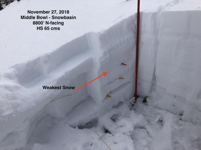
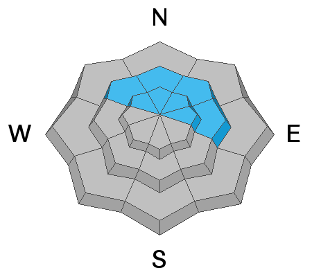
Slopes at upper elevations that face N and NE are the ones that potentially harbor faceted layers that could produce avalanches today. If winds begin transporting and drifting snow this afternoon onto northerly facing slopes, the danger could increase. The avalanche danger is MODERATE on all upper elevation northerly and east facing slope. All other slopes have a LOW avalanche danger.
Low
Moderate
Considerable
High
Extreme
Learn how to read the forecast here
Special Announcements
Join us for the 2nd annual Ogden Backcountry Bash TONIGHT! 630pm at the Front Climbing Gym. All proceeds go to support backcountry avalanche forecasting and education in the Ogden mountains. More info here.
Weather and Snow
Since yesterday 5-7 inches of snow (0.4-0.8" of water) fell near Snowbasin. 8-10 inches of snow (1" of water) fell near Ben Lomond and Monte Cristo Peaks.
Winds blew a bit stronger overnight but were generally light this morning at 5-10 mph from the WSW with some gusts 15-20 mph.
Temperatures this morning are near 30 degrees F at trailhead elevations and in the low 20s F near 9000 feet.
The snowpack is slowly building.
  • Near Snowbasin at 8000 feet, it is 20-30 inches deep.
  • On Ben Lomond it is 12-18 inches deep.
  • At Monte Cristo at 8900 feet, it is 22 inches deep.
Today will have a lull in snowfall with more coming this afternoon when winds will increase and blow from the S and SW at 20-30 mph with higher gusts. A few inches of snow should fall by the end of the day. Temperatures today should warm into the mid 30s F in many areas. Total snowfall by tomorrow morning should be 6-10 inches. Snowfall will continue Friday.
Recent Avalanches
No recent avalanches have been reported.
Ad
Avalanche Problem #1
Persistent Weak Layer
Type
Location
Likelihood
Size
Description
The Ogden area mountains had minimal old snow on the ground prior to Thanksgiving. A few areas at upper elevations have this old snow on N and NE aspects. Greg and the Snowbasin snow safety team found some faceting in the snow that fell on Thanksgiving day (see photo below). The load of today's new snow will test this potential weak layer, but I'm unsure how it will react. Look for natural avalanches, look for collapsing or cracking, and use small test slopes to see how this layer of Thanksgiving snow or isolated pockets of October snow reacts. Also, perform several stability tests. In the long run, today's warm, dense snow will help heal any weaknesses in the snowpack. For today, I wouldn't trust it too much.
Avalanche Problem #2
Wind Drifted Snow
Type
Location
Likelihood
Size
Description
Watch for drifting snow this afternoon when winds increase from the S and SW and possible form shallow wind slabs. The additional weight of these wind slabs could also cause avalanches to break deeper on some of the older snow layers from October or Thanksgiving day.
Additional Information
General Announcements
This information does not apply to developed ski areas or highways where avalanche control is normally done. This advisory is from the U.S.D.A. Forest Service, which is solely responsible for its content. This advisory describes general avalanche conditions and local variations always occur.