Forecast for the Ogden Area Mountains

Drew Hardesty
Issued by Drew Hardesty for
Saturday, January 12, 2019
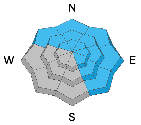
Many areas have a LOW avalanche danger. Very localized areas of MODERATE danger, however, exist for triggering an avalanche that breaks 1-2' deep into faceted snow on northwest through east to southeast facing terrain at all elevations. Continue to approach recent wind drifted slopes with caution. Don't overstay your welcome on steep sunny aspects with daytime warming.

Safe travel protocol is key: make a plan, communicate, one-at-a-time, keep eyes on your partner.
Low
Moderate
Considerable
High
Extreme
Learn how to read the forecast here
Special Announcements
We just released the first UAC podcast of the 2018/2019 season "Guilt". It's one of many short pieces (5 min) to mix in between our longer conversations.

Join the UAC, Greg Stump, and Scot Schmidt for the 30th Anniversary of Blizzard of Aahhh's at Brewvies on January 24. Scott Schmidt and Greg Stump will be signing posters and the MCs for an evening of big air, big hair, and lots of laughs.
Weather and Snow
Greg Gagne's Most Excellent Week in Review is hot off the presses. Look for it in the Blog menu above or simply click here.

Skies are clear with mountain temps in the low 20s. Winds veered clockwise overnight and are light from the east-northeast. Fair weather persists through Monday with a storm out of the west/southwest for mid-week. Some of the models are quite bullish on projected snow and water amounts. Stay tuned. For today, expect clear skies, light easterly winds, and mountain temps rising to the mid to upper 20s in the high country. Should be a good day to get out and about.
Skiing and riding conditions are good with pretty darn good coverage across the range, even at the lower elevations. Total snow depths are a settled 45-55". Many trailheads and lower elevation exits have snow depths from 35-45" (elevations roughly 6000'). Sunny aspects are crusted and the best snow can be found in the wind sheltered shady terrain.
Recent Avalanches
No new avalanche activity was reported from the backcountry yesterday. Ski area control teams triggered a few wind slabs and cornice fall with explosives along the Ogden skyline.
Ad
Avalanche Problem #1
Persistent Weak Layer
Type
Location
Likelihood
Size
Description
The mountain snowpack harbors more than a few structural irregularities and interfaces that involve pockety old faceted October snow in the basement as well as pre-Christmas and post-New Year's buried weak layers. These seem to be weakest at the low and mid-elevations and this seems to fall in line with the natural avalanche activity noted by Kory, Bill, Doug and others from earlier in the week. Still, time, warm temps, and settlement has helped the snowpack to adjust and slowly stabilize over the past few days, but I still need some more data points from some of the outlier portions of the range to feel completely confident.

Greg Gagne, Doug Wewer and I toured up in the Cutler area Thursday...and Bill Brandt was nearby and to the south. We all found mostly stable conditions with pockety, if unreactive, areas of the New Year's weak layers. Kory Davis and team found similar conditions further to the south below the Ben Lomond massif; yet there is still some wariness from all the activity earlier in the week. You can find our observations in the menu above.
Additional Information
More good info, as always, can be found on Instagram at ogdenavalanche or #ogdenavalanche. If you're recreating in the far northern end of the zone, consider looking at the Logan avalanche forecast. They have very interesting avalanche conditions there, particularly at the low elevations and foothills.
General Announcements
This information does not apply to developed ski areas or highways where avalanche control is normally done. This forecast is from the U.S.D.A. Forest Service, which is solely responsible for its content. This forecast describes general avalanche conditions and local variations always occur.