UDOT PLANNED AVALANCHE CLOSURES!!

Forecast for the Moab Area Mountains

Nikki Champion
Issued by Nikki Champion for
Tuesday, April 11, 2023
With no overnight refreeze, and such warm temperatures there is a MODERATE avalanche danger for wet avalanches on almost all aspects and elevations.
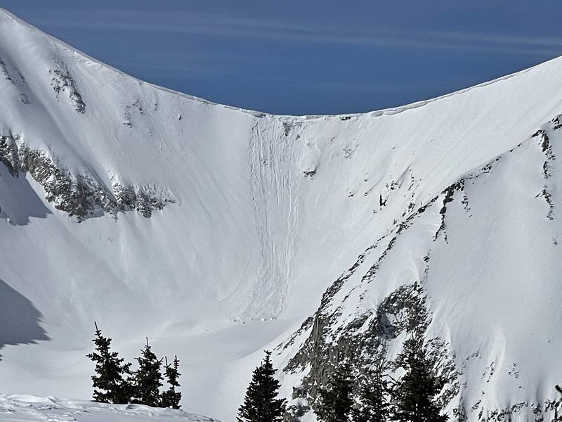
Avalanches will begin to happen naturally today, and the wet-loose debris can stack up very deep, especially in terrain traps like gullies. It's possible with enough sunshine today; the avalanche danger may rise to CONSIDERABLE for wet snow avalanches on slopes facing SW-S-SE.
Keep an eye on the snow surface. If you start seeing signs that the snow surface becoming unsupportable, it's time to re-evaluate your terrain.

The cornices are massive, and with such warm temperatures, natural cornice fall will be likely today. Give cornices, and slopes below cornices a wide berth.
Low
Moderate
Considerable
High
Extreme
Learn how to read the forecast here
Special Announcements
Geyser Pass Road: The road is open. 4x4 recommended. Expect the road to be wet, sloppy, and muddy in the afternoon.
Grooming: Trails were groomed into Gold Basin on Wednesday.
The final UAC report for the Upper Weber Canyon avalanche accident on March 9 has been published and is available HERE. The UAC would like to thank Park City Powder Cats for sharing information about the timeline of the accident and allowing UAC staff access to the avalanche after the incident.
Weather and Snow
6:00 a.m. Snow and Weather Data
24 Hour Snow 0" 72 Hour Snow 0" Season Total Snow 315" Base Depth at Gold Basin 104"
Temp 35 F Winds on Pre-Laurel Peak: S 25 G 29

Weather
This morning, mountain temperatures are currently in the mid to upper 30s F in Gold Basin. Winds transitioned more southerly overnight, and are now averaging 20-25 mph, with gusts near 30 mph.
Today, skies will be mostly sunny, with temperatures climbing into the upper-40s F and mid-50s F. The south winds will remain elevated, averaging 20 mph. With this bump in warm temperatures Tuesday through Thursday, will come a large bump in the winds as well. By Thursday we could see wind speeds up to 55 mph in the mountains.
General Conditions
Strong winds, warm temperatures, and intense April sun are taking a toll on the snowpack. We have found that high-elevation North faces have been holidng the best snow, but I would guess that is becoming more scarce with every warm day. Once you lose some elevation the skiing gets a bit slow and manky on Northerlies, and the snow surface is becoming saturated and wet on the solars. With no overnight refreeze, solar aspects will be wet this morning and only continue to saturate throughout the day.
With the extremely warm weather on the way, I would expect avalanche danger to be on the rise now that the snowpack is no longer freezing overnight.

Snowpack and Weather Data
Gold Basin Storm Stake (10,000')
Gold Basin SNOTEL site (10,000')
SNOTEL site near Geyser Pass Winter Trailhead (9600')
Wind Station on Pre-Laurel Peak (11,400')
NWS forecast for the La Sal Mountains.
Recent Avalanches
On Saturday, there was on natural cornice fall in the Red Snow Cirque saddle between Tuk and Tuk No. This cornice failed on a Northeast aspect around 11,900' and the debris ran about 450' below it. Check out the full observation HERE.
Photo of the cornice fall (T. Matthews)
See the La Sal avalanche database here.
Ad
Avalanche Problem #1
Wet Snow
Type
Location
Likelihood
Size
Description
As the temperatures increase today, wet-loose avalanches will become likely on aspects facing west to south to east. The northerly slopes will remain colder longer, but with such warm temperatures today, I would expect the snow surface to become wet and avalanches to begin occurring on lower and mid-elevation northerlies.
While most of the avalanche activity will be wet-loose type avalanches, with prolonged periods of above-freezing temperatures, there becomes a possibility that you can trigger a wet slab avalanche deeper into the snowpack that fails on old crusts or softer (colder) layers deeper down. Remember to watch your exits and plan to avoid terrain traps in the day's heat.
Cornices: We have gotten a few reports of natural cornice fall. Cornices are currently large and only continue to grow in the backcountry. With today's warm temperatures, we will continue to see more cornices breaking naturally. Give cornices, and the edges of cornices a wide berth as they often break farther back than expected. Limit your exposure to slopes below cornices.
Additional Information
This graph is from the Snotel site near the Geyser Pass Winter TH. The black line is our current season. Total SWE is 230% of normal.
General Announcements
This forecast is from the U.S.D.A. Forest Service, which is solely responsible for its content. This forecast describes general avalanche conditions and local variations always occur. This forecast will be updated by 7:30 tomorrow morning.