UDOT PLANNED AVALANCHE CLOSURES!!

Forecast for the Moab Area Mountains

Nikki Champion
Issued by Nikki Champion for
Monday, April 10, 2023
The snowpack is generally stable and the avalanche danger is LOW. The two concerns are wet-loose avalanches on steep sun-exposed slopes that face W-S-E, and isolated pockets of wind-drifted snow in exposed terrain at the upper elevations.
Another solid overnight refreeze should keep wet snow at bay today, but if you find yourself in steep, sunlit terrain today, keep an eye on the snow surface. If you start seeing signs that the snow surface becoming damp and unsupportable, it's time to re-evaluate your terrain and change your aspect to a cooler, more shady slope.

Risk is inherent in mountain travel; getting caught in even a small avalanche could have serious consequences in steep, rocky terrain.
Low
Moderate
Considerable
High
Extreme
Learn how to read the forecast here
Special Announcements
Geyser Pass Road: The road is open. 4x4 recommended. Expect the road to be wet, sloppy, and muddy in the afternoon.
Grooming: Trails were groomed into Gold Basin on Wednesday.
Weather and Snow
6:00 a.m. Snow and Weather Data
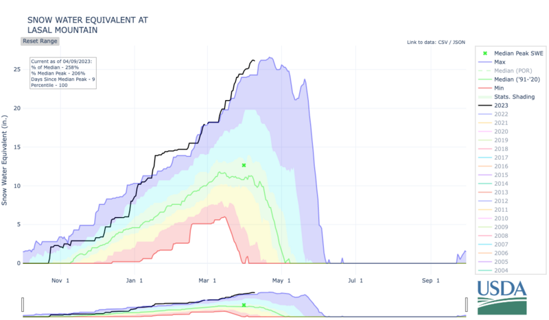
24 Hour Snow 0" 72 Hour Snow 0" Season Total Snow 315" Base Depth at Gold Basin 104"
Temp 26 F Winds on Pre-Laurel Peak: NW 5 G 5

Weather
This morning, mountain temperatures are currently hovering around the low to mid 20s F in Gold Basin. Winds transitioned more easterly overnight, and are now averaging below 5 mph.
Today, skies will be mostly sunny, with temperatures climbing into the mid-40s F and even low 50s F in places. The east winds should remain calm, averaging 5-10 mph. While today will be warm, the big warm-up comes over the next 3 days as mountain temperatures could reach the upper 50s F. With the bump in warm temperatures Tuesday through Thursday, will come a large bump in the winds as well. By Wednesday we could see wind speeds up to 50 mph in the mountains.
General Conditions
Strong winds, warm temperatures, and intense April sun are taking a toll on the snowpack. We have found that high-elevation North faces are holidng the best snow. Once you lose some elevation the skiing gets a bit slow and manky on Northerlies, and the snow surface is becoming saturated and wet on the solars. With cooler overnight temperatures, solar aspects will be firmly crusted over this morning, but likely softening quickly due to the strong sun and warm temperatures. You can travel safely on the solars early in the day, but as things heat up you may want to move to more Northerly aspects to avoid wet avalanche activity. At the highest elevations, you may still encounter shallow, soft slabs of wind-drifted snow in isolated areas on slopes with a Northerly or Easterly component to their aspect.
With the extremely warm weather on the way, I would expect avalanche danger to be on the rise once overnight temperatures are no longer below freezing.

Snowpack and Weather Data
Gold Basin Storm Stake (10,000')
Gold Basin SNOTEL site (10,000')
SNOTEL site near Geyser Pass Winter Trailhead (9600')
Wind Station on Pre-Laurel Peak (11,400')
NWS forecast for the La Sal Mountains.
Recent Avalanches
No new avalanches were reported yesterday.
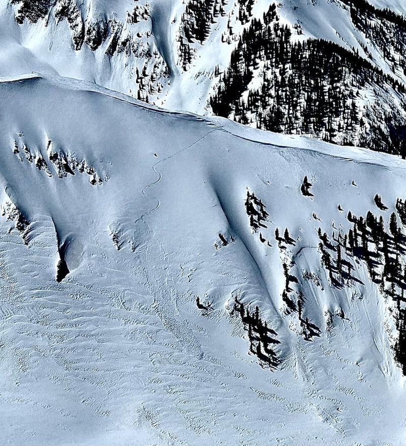
On Friday, a skier triggered this shallow, soft slab of wind-drifted snow in Old Reliable on an NNE aspect at 11,300 ft.
See the La Sal avalanche database here.
Ad
Avalanche Problem #1
Normal Caution
Type
Location
Likelihood
Size
Description
The snowpack is generally stable and natural and human-triggered avalanches are unlikely. In isolated areas, you may encounter:
  1. Wet-loose avalanches on steep sun-exposed slopes. Yesterday, we found the solar aspects becoming very wet in the afternoon. Today is a repeat performance with sunny skies and temperatures above freezing. If you see roller balls or notice saturated, slushy snow, it is time to change aspects. As the temperatures climb over the next few days, and the snowpack begins not fully freezing overnight, we will begin seeing more widespread wet activity.
  2. Very isolated pockets of fresh wind drifted snow along exposed ridges and in open terrain at the upper elevations.
Multiple parties have been skiing steep lines in big terrain lately. Keep in mind that low danger does not mean no danger. Here are some things to consider if you are heading for big objectives today:
  • Travel one at a time through avalanche terrain. Leave the rest of the party in a safe spot ready to perform a rescue
  • Communicate with other parties, and do not ski above other groups
  • Consider the consequences of your terrain choices - what will happen if it slides? Are you above a cliff or terrain trap?
  • Stay well back from cornices, and avoid traveling beneath large cornices.
Additional Information
This graph is from the Snotel site near the Geyser Pass Winter TH. The black line is our current season. Total SWE is 230% of normal.
General Announcements
This forecast is from the U.S.D.A. Forest Service, which is solely responsible for its content. This forecast describes general avalanche conditions and local variations always occur. This forecast will be updated by 7:30 tomorrow morning.