Forecast for the Moab Area Mountains

Eric Trenbeath
Issued by Eric Trenbeath on
Monday morning, March 27, 2023
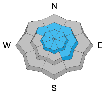
The danger is MODERATE and human triggered avalanches up to 3' deep remain possible on steep, northerly aspects near treeline and above.

Be on the look out for freshly formed slabs of wind drifted snow on all aspects above treeline today.

Watch out for loose, dry sluffs on steep slopes in the most recent snow. As the day heats up these may turn to loose wet avalanches on sun exposed slopes.
Low
Moderate
Considerable
High
Extreme
Learn how to read the forecast here
Special Announcements
10:00 a.m. update: Geyser Pass Road: Grand County is widening the road and the gate is closed.
Grooming: Trails were groomed Saturday but will be covered in fresh snow this morning.
Weather and Snow
6:00 a.m. Snow and Weather Data
24 Hour Snow 6" 72 Hour Snow 10" Season Total Snow 294" Base Depth at Gold Basin 103"
Temp 0˚ F Winds on Pre-Laurel Peak: WNW 8-16

Weather
The shortwave trough responsible for last night's snow has moved on leaving clearing skies and frigid temperatures in its wake. A January-like day in the mountains is in store with sunny skies, breezy NW winds blowing 15-20 mph, and high temps in the mid teens. Skies will remain clear on Tuesday with high temps in the mid to upper 20's. Clouds should start to develop Tues night ahead of a deep low pressure system moving down the west coast. This storm will begin its trek across the Great Basin on Wednesday, bringing snow to our area likely on Thursday. A long wave trough pattern will keep things unsettled into next week.

General Conditions
6" of fresh, low density snow will make for great turning and riding conditions on all aspects today. Pesky, NW winds will be blowing the new snow around a bit at upper elevations so be on the lookout for developing fresh slabs of wind drifted snow. The new snow may also be prone to sluffing in steep terrain. Normally this time of year I'd be concerned about the effects of the sun on the new snow, but temps are going to be very cold today. Nevertheless, keep an eye on things and look for signs of loose, wet instability such as rollerballs or pinwheels.
Instabilities from last week's load of dense, heavy snow have largely settled out, but thick, cohesive slabs have developed in some areas, particularly where wind drifted. Steep, northerly aspects remain suspect, and human triggered avalanches up to 3' deep remain possible.

Snowpack and Weather Data
Gold Basin Storm Stake (10,000')
Gold Basin SNOTEL site (10,000')
SNOTEL site near Geyser Pass Winter Trailhead (9600')
Wind Station on Pre-Laurel Peak (11,400')
NWS forecast for the La Sal Mountains.
Recent Avalanches
Old news, but yesterday I went and checked out a unique avalanche at a relatively low elevation over in the North Group that was first reported by Brian Murdock. Presenting as a long running, loose wet avalanche, it actually appeared to have initiated as a wind driven storm slab right above the rain/snow line last Wednesday. Once it got going it gathered rain saturated snow and produced an impressive pile of debris.
Ad
Avalanche Problem #1
Wind Drifted Snow
Type
Location
Likelihood
Size
Description
6" of new, low density snow will be easily transported by increasing NW winds today. Be on the lookout for shallow, fresh slabs of wind drifted snow forming on the leeward sides of ridge crests and terrain features in upper elevation, wind exposed terrain.
Thursday and Friday, westerly winds were actively building slabs on on slopes facing NW-N-NE-E-SE, with the greatest danger existing above treeline. And finally, thick slabs of wind drifted snow that formed during last week's storm cycle remain a concern and they are now well camouflaged. These older slabs are growing more stubborn, and you may have to be well on to a slope before they release. They are most problematic on steep northerly aspects above treeline, and human triggered avalanches up to 3' deep remain possible in these areas. Suspect steep slopes that have a smooth rounded appearance or that feel hollow underneath. Likely trigger points include steep convexities, or blind break-overs.
Avalanche Problem #2
Normal Caution
Type
Location
Likelihood
Size
Description
Conditions are unusual for this time of year. Cold temperatures and successive storms are creating winter-like conditions in the snowpack and things are not stabilizing as rapidly as they normally would in March and you still need to travel with a high level of avalanche awareness.
  • 2' of heavy, dense snow last week formed a cohesive slab in the snowpack. Instabilities within this slab have largely settled out, but it still remains possible to trigger an avalanche, especially in areas where it has been wind drifted. In isolated areas at lower elevations, this slab is sitting over weak, shallow snow and some collapsing has been observed. Minimize your exposure by avoiding areas of steep, radical terrain, or areas that show signs of wind drifting.
  • Sluffing in the most recent snow may occur on very steep slopes today.
  • Though its going to remain cold, the strong March sun may heat up the snow surface. Look for signs of loose, wet instability such as rollerballs or pinwheels.
General Announcements
This forecast is from the U.S.D.A. Forest Service, which is solely responsible for its content. This forecast describes general avalanche conditions and local variations always occur. This forecast will be updated by 7:30 tomorrow morning.