Fall Auction is now live! Check it out now

Forecast for the Moab Area Mountains

Dave Garcia
Issued by Dave Garcia on
Tuesday morning, March 28, 2023
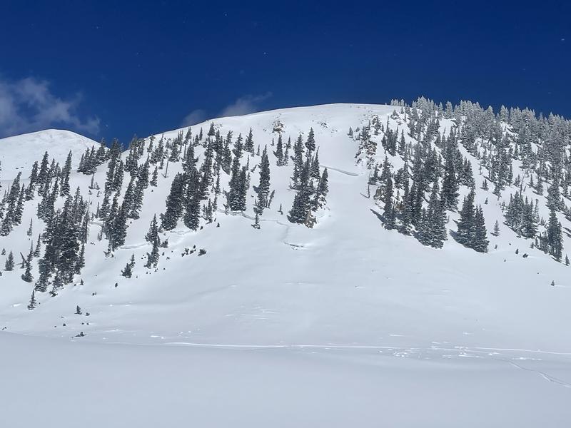
The overall danger is MODERATE. Backcountry travelers should be aware of fresh, sensitive slabs of wind drifted snow forming today on Northerly aspects above treeline. It remains possible to trigger avalanches up to three feet deep on old hard slabs of wind drifted snow near treeline and above on slopes that face NW-N-NE-E-SE.
Sluffs, or dry loose avalanches remain possible in steep terrain.
As the day heats up, wet loose avalanches may become possible on solar aspects.
Low
Moderate
Considerable
High
Extreme
Learn how to read the forecast here
Special Announcements
Geyser Pass Road: Grand county will be working on the Geyser Pass road today. Expect it to close around 9 AM and reopen sometime in the afternoon.
Grooming: Trails were groomed Saturday.
Weather and Snow
6:00 a.m. Snow and Weather Data
24 Hour Snow 0" 72 Hour Snow 10" Season Total Snow 294" Base Depth at Gold Basin 111"
Temp -4.2˚ F Winds on Pre-Laurel Peak: SSE 14 G 26

Weather
Temperatures remain cold and it is once again sub-zero in Gold Basin. The sun will be shining this morning and temperatures will warm to 24 degrees. Southerly winds will blow in the 10-20 mph range. Look for increasing clouds this afternoon. On Wednesday, a strong Southwest flow sets up ahead of the approaching low pressure system. Cloud cover will build and Southerly winds will increase ahead of a wet and quick moving system that will impact the La Sals Thursday and Friday. This system will bring strong winds and heavy snow, with the heaviest snowfall expected on Thursday.

General Conditions
Skiing and riding conditions are about as good as they get right now. Solar aspects have been good for three consecutive days, but may finally have a thin sun crust on them this morning. We should see enough sunshine today that backcountry travelers should be alert to signs of loose wet instability such as roller balls and heavy wet snow. The best skiing today will be on Northerly aspects, where you will find cold, deep powder. Yesterday, we found the most recent storm snow to be loose and unconsolidated. Sluffing in steep terrain remains a possibility. Recent heavy snowfall and strong winds have built thick cohesive slabs in alpine terrain. Steep, northerly aspects above treeline remain the most likely place to trigger an avalanche today.
Yes - it is that good out there! Professional avalanche educator Tim Matthews getting the goods yesterday.

Snowpack and Weather Data
Gold Basin Storm Stake (10,000')
Gold Basin SNOTEL site (10,000')
SNOTEL site near Geyser Pass Winter Trailhead (9600')
Wind Station on Pre-Laurel Peak (11,400')
NWS forecast for the La Sal Mountains.
Recent Avalanches
Yesterday Tim and I got a look at two impressive avalanches that broke 4-5 deep and failed on facets during the height of the storm last week. You can view the details here and here.
And Eric has a great write-up on a somewhat anomalous avalanche that occurred last week on Grand View Peak, near Miner's Basin.
Ad
Avalanche Problem #1
Wind Drifted Snow
Type
Location
Likelihood
Size
Description
6" of new, low density snow will be easily transported by increasing SW winds today. Be on the lookout for shallow, fresh slabs of wind drifted snow forming on the leeward sides of ridge crests and terrain features in upper elevation, wind exposed terrain.
Last week's series of heavy snowfall and strong winds built thick cohesive slabs of snow on Northerly facing slopes in the alpine. The older slabs are becoming harder to trigger, but it remains possible for a skier or rider to find a piece of snow that will be sensitive to their weight. This is somewhat complicated by the new snow that fell Sunday night and has covered up these older, deeper drifts making them hard to detect. Likely trigger points include steep convexities, or blind break-overs. If triggered, these avalanches can be up to three feet deep.
Avalanche Problem #2
Normal Caution
Type
Location
Likelihood
Size
Description
Conditions are unusual for this time of year. Cold temperatures and successive storms have created winter-like conditions in the snowpack and things are not stabilizing as rapidly as they normally would in March and you still need to travel with a high level of avalanche awareness.
  • In our travels yesterday, we found the most recent snow to be loose and unconsolidated. We experienced some minor sluffing. Expect sluffs to be possible today in sustained, steep terrain. Use good sluff management techniques if you are riding steep terrain.
  • Wet loose avalanches may become possible today on Solar aspects. This will depend on how quickly the clouds build later this afternoon. If the sun is shining for most of the day, be aware that solar aspects will heat up and become dangerous. Roller balls and heavy, wet, saturated snow are signs that it is time to change aspects.
General Announcements
This forecast is from the U.S.D.A. Forest Service, which is solely responsible for its content. This forecast describes general avalanche conditions and local variations always occur. This forecast will be updated by 7:30 tomorrow morning.