Fall Auction is now live! Check it out now

Forecast for the Moab Area Mountains

Dave Garcia
Issued by Dave Garcia on
Wednesday morning, March 29, 2023
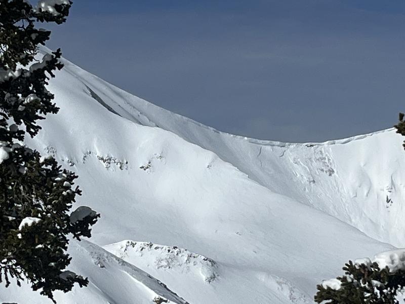
The avalanche danger today is MODERATE. Human triggered avalanches are POSSIBLE in fresh, unstable slabs of wind drifted snow near treeline and above on slopes that face W-N-SE. Backcountry travelers should avoid all steep slopes that have been recently loaded by wind.
The avalanche danger will be on the rise tomorrow, as a quick moving storm will bring snow and strong winds to the La Sals.
Low
Moderate
Considerable
High
Extreme
Learn how to read the forecast here
Special Announcements
Geyser Pass Road: The road is open.
Grooming: Trails were groomed Saturday.
On Monday, March 27, two snowmobilers were riding in the Oquirrh Mountains. One was caught, carried, and fully buried in a very large avalanche. His partner, friends and family, Utah County Search and Rescue, Utah Department of Public Safety, and LifeFlight participated in the rescue, but he sadly did not survive. The preliminary avalanche report can be found HERE.
Our sincerest condolences go out to everyone affected by this tragic avalanche.
Weather and Snow
6:00 a.m. Snow and Weather Data
24 Hour Snow 0" 72 Hour Snow 0" Season Total Snow 294" Base Depth at Gold Basin 110"
Temp 28 F Winds on Pre-Laurel Peak: S 33 G 38

Weather
Temperatures in Gold Basin are 30 degrees warmer than this time yesterday morning. It is currently 28 degrees and the high should be right around freezing at 10,000 ft. Clouds will build ahead of the incoming low pressure system. The real story is the wind. Winds on Pre-Laurel have been blowing in the 30-40 mph range out of the South, and this trend will continue today. Snowfall will begin Thursday morning. This quick moving storm should produce 6-10 inches of snow for the La Sals, with the heaviest amounts falling during the day on Thursday. Things clear up for Friday, but it looks like strong winds stay with us for a while. The pattern remains unsettled through the weekend and into early next week.

General Conditions
What a run of great ski days it's been lately. Conditions have taken a slight hit from two days of strong March sun and now relentless Southerly winds. You can still find plenty of soft powder in sheltered trees on the shady side of the compass. Six inches of low density snow fell on Sunday night. The strong Southerly winds that ramped up yesterday will have no trouble blowing and drifting this cold smoke into fresh, sensitive drifts. Your primary avalanche concern today is wind drifted snow on Northerly facing slopes.

Snowpack and Weather Data
Gold Basin Storm Stake (10,000')
Gold Basin SNOTEL site (10,000')
SNOTEL site near Geyser Pass Winter Trailhead (9600')
Wind Station on Pre-Laurel Peak (11,400')
NWS forecast for the La Sal Mountains.
Recent Avalanches
Yesterday Taylor Martin reported a natural cornice fall that triggered an avalanche in Red Snow Cirque.
On Monday Tim Matthews and I got a look at two impressive avalanches that broke 4-5 deep and failed on facets during the height of the storm last week. You can view the details here and here.
And Eric has a great write-up on a somewhat anomalous avalanche that occurred last week on Grand View Peak, near Miner's Basin.
Ad
Avalanche Problem #1
Wind Drifted Snow
Type
Location
Likelihood
Size
Description
Strong Southerly winds were transporting snow all day yesterday. These winds will continue to blow and drift snow today, creating unstable slabs of wind drifted snow on leeward slopes near treeline and above. Freshly formed wind slabs can be quite sensitive and are often remotely triggered. This problem will be most pronounced on upper elevation slopes that face W-N-E. Shooting cracks in drifted snow are a sure sign of instability. Backcountry travelers should avoid any steep slopes that have been recently loaded.
Avalanche Problem #2
Normal Caution
Type
Location
Likelihood
Size
Description
A series of recent storms and strong winds have created and intricately layered snowpack in the La Sals. Conditions have felt more like winter, and the snowpack has not stabilized as fast as it typically would in late March.
The snowpack does not like rapid change, and temperatures are 30 degrees warmer than they were 24 hours ago. Some instabilites in the snow surface may be lingering from yesterday's rapid warm up and today's continued warm temperatures. I would not be surprised to see steep slopes shedding some snow today, especially with the added weight of a skier or rider. Travel smart, and be alert to signs of wet activity in the snow surface. If you notice wet slushy snow, or roller balls moving downhill, it's time to move off steep terrain.
General Announcements
This forecast is from the U.S.D.A. Forest Service, which is solely responsible for its content. This forecast describes general avalanche conditions and local variations always occur. This forecast will be updated by 7:30 tomorrow morning.