Fall Auction is now live! Check it out now

Forecast for the Moab Area Mountains

Eric Trenbeath
Issued by Eric Trenbeath on
Thursday morning, March 30, 2023
Be alert to changing conditions and a potential rise in danger today!
The avalanche danger is MODERATE but could rise to CONSIDERABLE as the day progresses. Human triggered avalanches involving unstable slabs of wind drifted snow are possible near treeline and above on slopes that face W-N-SE. Fresh drifts will become deeper and more widespread as new snow accumulates. Backcountry travelers should avoid all steep slopes that have recent deposits of wind drifted snow.

Cornices are becoming very large in some areas. Increased wind loading will make them more sensitive so give them a wide berth.
Low
Moderate
Considerable
High
Extreme
Learn how to read the forecast here
Special Announcements
Geyser Pass Road: The road is open.
Grooming: Trails were last groomed on Saturday.
On Monday, March 27, two snowmobilers were riding in the Oquirrh Mountains. One was caught, carried, and fully buried in a very large avalanche. His partner, friends and family, Utah County Search and Rescue, Utah Department of Public Safety, and LifeFlight participated in the rescue, but he sadly did not survive. The preliminary avalanche report can be found HERE.
Our sincerest condolences go out to everyone affected by this tragic avalanche.
Weather and Snow
6:00 a.m. Snow and Weather Data
24 Hour Snow 0" 72 Hour Snow 0" Season Total Snow 294" Base Depth at Gold Basin 110"
Temp 28 F Winds on Pre-Laurel Peak: NA

Weather
An approaching cold front will bring strong southerly winds and a shot of snow to the mountains today. It looks like we may see more wind than snow with 3"-5" likely by days end. SW winds will blow in the 35-40 mph range with gusts in the 50's. High temps will be in the upper 20's. Snow lingers into tonight with another inch or two possible. Temps crater overnight and winds shift to more westerly, decreasing by about 10 mph. The storm moves on early Friday and we should see clearing skies and breezy, westerly winds. A shortwave ridge brings warm and dry air, with continued breezy conditions through the weekend. Another round of storminess is shaping up for early next week.

General Conditions
Conditions have taken a turn as southerly winds have hammered the peaks over the past 36 hours. Pre Laurel Peak has been down since midnight, but averages all day yesterday were in the 30-40 mph range with gusts as high as 60. Suffice it to say they are still blowing similarly. As a result you will 1) have to seek out sheltered, northerly aspects for good snow, and 2) be on the lookout for fresh slabs of wind drifted snow. Be alert to changing conditions today as fresh slabs become deeper and more widespread with accumulating snowfall.
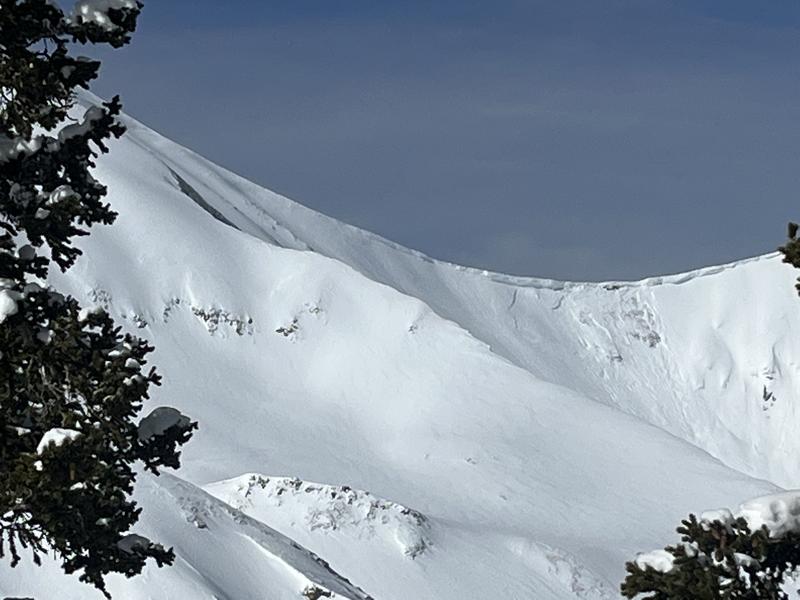
Cornices have grown huge in some areas and are teetering on the edge. Give them a wide berth as we have at least one report of one breaking off and triggering an avalanche.

Snowpack and Weather Data
Gold Basin Storm Stake (10,000')
Gold Basin SNOTEL site (10,000')
SNOTEL site near Geyser Pass Winter Trailhead (9600')
Wind Station on Pre-Laurel Peak (11,400')
NWS forecast for the La Sal Mountains.
Recent Avalanches
Taylor Martin reported a natural cornice fall that triggered an avalanche in Red Snow Cirque on Tuesday.
See the complete La Sal avalanche database here.
Ad
Avalanche Problem #1
Wind Drifted Snow
Type
Location
Likelihood
Size
Description
Strong southerly winds continue to blow and drift snow creating unstable slabs on leeward slopes near treeline and above. Fresh drifts will become deeper and more widespread as new snow accumulates. The problem will be most pronounced on upper elevation slopes with a north or easterly aspect, but cross-loading may also occur on slopes facing west or southeast. Look for fresh drifting on the leeward sides of ridge crests and terrain features such as gully walls and sub ridges. Shooting cracks in drifted snow are a sure sign of instability. Backcountry travelers should avoid any steep slopes that have recent deposits of wind drifted snow.
General Announcements
This forecast is from the U.S.D.A. Forest Service, which is solely responsible for its content. This forecast describes general avalanche conditions and local variations always occur. This forecast will be updated by 7:30 tomorrow morning.