UDOT PLANNED AVALANCHE CLOSURES!!

Forecast for the Moab Area Mountains

Eric Trenbeath
Issued by Eric Trenbeath for
Tuesday, March 26, 2019
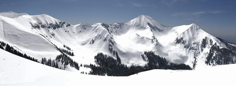
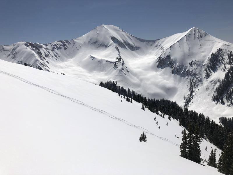
The avalanche danger will rise to MODERATE today for wet snow avalanches on sun exposed slopes. The danger will develop first on east facing slopes followed by south, and then west. Low elevation, northerly aspects are also susceptible. Roller balls, pinwheels, and loose snow sluffs are signs of instability. Work with the sun, and get off of steep slopes as they become wet and sloppy. There also remains an isolated, or MODERATE danger for triggering a deep avalanche failing on a buried persistent weak layer. Though triggering this type of avalanche has grown increasingly unlikely, the consequences have not, and this type of avalanche is un-survivable. This problem is most acute on steep slopes facing NW-N-E right around treeline and above. You may also find a few sensitive wind drifts in these same areas.
Low
Moderate
Considerable
High
Extreme
Learn how to read the forecast here
Special Announcements
We need your help. In an effort to increase awareness and prevent future fatalities we need to reach more people with our daily avalanche forecasts, expand the Know Before You Go program, and increase the number of on-snow avalanche courses. Please consider a donation to the UAC to help us raise $25,000 by April 8. Show your support of the UAC by making a donation at https://utahavalanchecenter.org/donate
A big shout out to the sledders in San Juan County who completed a Motorized Backcountry 101 Course this weekend! And a huge thanks to Al and Eston from Backcountry Institute for putting on the course!
Weather and Snow
High, thin cirrus clouds are moving through the area, and SE winds are on the increase averaging 20-25 mph along ridge tops. 10,000' temps are in the low 20's. Little change is in store over the next few days. We'll see mostly sunny skies through Thursday with daytime high temps in the low 40's, and overnight lows in the mid to high 20's. Southerly winds will blow in the 20-25 mph range with higher gusts along ridge tops. A weak, and disorganized system will bring clouds and a chance of snow showers on Friday.
It was a stellar spring day in the mountains yesterday with remarkably good snow conditions. Clouds over the past few days had preserved the powder in many slopes that I had expected to be crusted over. By the end of the day however, sun exposed, and low elevation slopes had succumbed to the effects of the sun and warm temperatures, and these surfaces will definitely be crusted over. You will have to seek upper elevation, northerly facing terrain to find powder today.
New snow totals in Gold Basin (10,000')
Snotel totals at the Geyser Pass Trailhead (9600')
Winds at 11,000 feet on Abajo Peak (11,330') about 45 miles south.
National Weather Service point forecast.
Recent Avalanches
No new avalanches have been reported. For a list of avalanches this season go here.
Ad
Avalanche Problem #1
Wet Snow
Type
Location
Likelihood
Size
Description
The danger for wet snow avalanches will rise on sun exposed slopes as temperatures soar into the low 40's. The danger will develop first in east facing slopes followed by south, and then west. Low elevation, northerly aspects are also susceptible. Roller balls, pinwheels, and loose snow sluffs are signs of instability. Work with the sun, and get off of steep slopes as they become wet and sloppy.
Avalanche Problem #2
Persistent Weak Layer
Type
Location
Likelihood
Size
Description
Though this type of avalanche is becoming increasingly unlikely, it still may be possible to trigger a deep and dangerous avalanche on a buried persistent weak layer. The problem is most acute on steep slopes facing NW-N-E. right around treeline and above. Shallower areas along slope margins, or near rocks and sparse trees are potential trigger points.
Avalanche Problem #3
Wind Drifted Snow
Type
Location
Likelihood
Size
Description
A few pockets of wind drifted snow, that may be sensitive to the weight of a skier or rider, still exist in the high country on slopes facing NW-N-E. If you are venturing into the steep, upper elevation terrain, be on the lookout for areas of wind deposited snow on the lee sides of ridge crests and terrain features.
General Announcements
Your information can save lives. If you see anything we should know about, please help us out by submitting snow and avalanche observations HERE. You can also call me at 801-647-8896, or send me an email: [email protected].
Support the UAC through your daily shopping. When you shop at Smith's, or online at REI, Backcountry.com, Patagonia, NRS, Amazon, eBay by clicking on these links, they donate a portion of your purchase to the UAC. If you sell on eBay, you can have your See our Affiliate Page for more details on how you can support the UAC when you shop
This forecast is from the U.S.D.A. Forest Service, which is solely responsible for its content. This forecast describes general avalanche conditions and local variations always occur.