Forecast for the Moab Area Mountains

Eric Trenbeath
Issued by Eric Trenbeath for
Friday, March 24, 2023
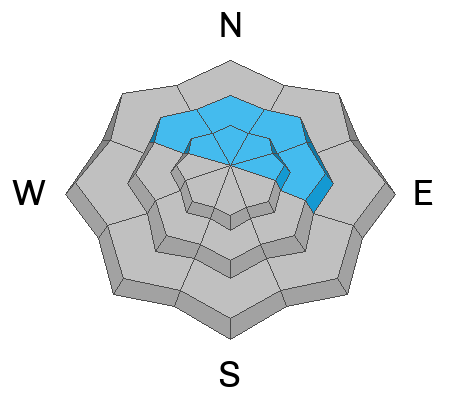
Areas of CONSIDERABLE danger exist on steep, wind drifted, northerly facing slopes above treeline.

The danger is MODERATE on all other aspects and elevations and human triggered avalanches are possible, with the greatest likelihood occurring on steep, wind, drifted northerly aspects.

Be alert to changing conditions today as fresh wind drifts may cause a rise in danger.
Low
Moderate
Considerable
High
Extreme
Learn how to read the forecast here
Special Announcements
Geyser Pass Road: Grand County has been performing double duty to keep access open but deep drifts were problematic for the graders above Trans La Sal yesterday. They are back at it today and the road will be closed above Trans La Sal.
Grooming: Trails are covered in new snow.
Weather and Snow
6:00 a.m. Snow and Weather Data
24 Hour Snow 4" 72 Hour Snow 8" Season Total Snow 284" Base Depth at Gold Basin 103"
Winds on Pre-Laurel Peak: SW 3 - 8 Temp 7˚ F

Weather
A broad low pressure system is parked over the region. An embedded shortwave trough will bring mostly cloudy skies, increasing SW winds, and developing snow showers later today. 3"-5" are possible with the highest snowfall rates occurring after 5:00 p.m. SW winds will blow in the 15-20 mph range by this afternoon, and increase by another 10 mph tonight with gusts to 35. Saturday looks mostly sunny, breezy, and cold followed by another weak, shortwave disturbance on Sunday. High pressure builds early next week with a return to a stormy pattern by around Thursday.

General Conditions
Seeing is believing and I cleaned 20" of dense snow off the storm board yesterday. With another 4" of low density snow last night, we're up to over 2' of snow at nearly 4.0" of Snow Water Equivalent (SWE) since Sunday night. The snow yesterday was dense, wind affected, and capped off by a thick, spongy, rime crust (see this observation from Chris Benson). It's not quite as bad as it sounds however, and with 4" of new, low density snow on top, it should be pretty good out there today. Neither Chris, or I observed any intstability in the most recent storm snow, and it seems to be stuck in there pretty well. But 4" is a lot of water weight, and it was pretty wild out there for a day or two. Drifts up to 3' deep have formed on northerly aspects and it's my feeling that there remains a pretty good likelihood for human triggered avalanches in these areas, especially above treeline.

Snowpack and Weather Data
Gold Basin Storm Stake (10,000')
Gold Basin SNOTEL site (10,000')
SNOTEL site near Geyser Pass Winter Trailhead (9600')
Wind Station on Pre-Laurel Peak (11,400')
NWS forecast for the La Sal Mountains.
Recent Avalanches
Things were pretty active during the height of the storm. Check out this great drone footage from Chris Benson, and view the La Sal avalanche database here.
Ad
Avalanche Problem #1
Wind Drifted Snow
Type
Location
Likelihood
Size
Description
Last night's 4" of new snow shouldn't affect the danger much, but as winds increase later today watch for it to be blown into fresh drifts. Fresh drifts could become deeper and more problematic if snowfall kicks in earlier than expected so be alert to changing conditions and look for signs of instability such as cracking in the snow surface.
Older slabs of wind drifted snow that formed on Wednesday remain a concern. They are most problematic on steep northerly aspects above treeline, and human triggered avalanches up to 3' deep are likely. Continue to avoid, steep, wind drifted, northerly facing slopes, especially in the high alpine.
Avalanche Problem #2
New Snow
Type
Location
Likelihood
Size
Description
We've picked up a lot of dense, heavy snow this week, and soft slab avalanches remain possible on all aspects and elevations today. The recent snow is showing signs of stabilizing, but I'm not yet ready to throw caution to the wind. Move into steeper terrain slowly, and use smaller "test slopes" to see how the snow is behaving.
General Announcements
This forecast is from the U.S.D.A. Forest Service, which is solely responsible for its content. This forecast describes general avalanche conditions and local variations always occur. This forecast will be updated by 7:30 tomorrow morning.