Forecast for the Moab Area Mountains

Eric Trenbeath
Issued by Eric Trenbeath for
Saturday, March 25, 2023
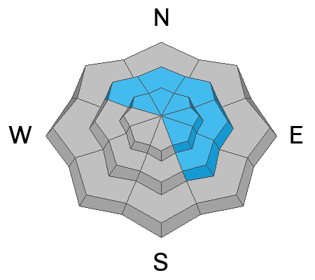
Areas of CONSIDERABLE danger exist on steep, wind drifted, slopes above treeline that face NW-NE-SE.
A MODERATE danger exists on all other aspects and elevations with an increasing danger on slopes with a northerly aspect.

Conditions remain unusually active for this time of year with a high likelihood for human triggered avalanches in upper alpine terrain. Incorporate this into your travel plans and make decisions accordingly.
Low
Moderate
Considerable
High
Extreme
Learn how to read the forecast here
Special Announcements
Geyser Pass Road: Grand County was able to push through to the Geyser Pass Trailhead yesterday and the road is open. However, new snow and strong winds yesterday afternoon have likely put some fresh drifts across the road. 4x4 required.
Grooming: Trails are not groomed this morning but may be later today.
Weather and Snow
6:00 a.m. Snow and Weather Data
24 Hour Snow 4" 72 Hour Snow 12" Season Total Snow 288" Base Depth at Gold Basin 103"
Winds on Pre-Laurel Peak: WNW 10-15 Temp 2˚ F

Weather
The shortwave trough responsible for yesterday's brief, but intense burst of wind and snow has moved on to the east leaving clear skies and January like temps in its wake. Today look for mostly sunny skies with cold temps barely making it into the mid teens. Breezy westerly winds will blow in the 15-20 mph range. Temps will again plummet tonight ahead of another shortwave trough moving through to the north on Sunday. Short lived high pressure builds Mon-Tue before the next Pacific storm system moves on shore Wed.

General Conditions
Turning and riding should be pretty good today with up to 8" of recent snow now sitting on top of Wednesday's rime crust. Moderate SW-NW winds yesterday blew and drifted snow all day long, especially above treeline, and by afternoon things got down right western up there. With almost 30" of snow this week, and occasional bouts of strong winds, thick slabs of drifted snow have developed on northerly aspects. Older slabs are now covered by new, and human triggered avalanches remain likely on steep, northerly aspects above treeline. Human triggered avalanches in recent and drifted snow remain possible on all other aspects and elevations.
Things really got after it yesterday afternoon!

Snowpack and Weather Data
Gold Basin Storm Stake (10,000')
Gold Basin SNOTEL site (10,000')
SNOTEL site near Geyser Pass Winter Trailhead (9600')
Wind Station on Pre-Laurel Peak (11,400')
NWS forecast for the La Sal Mountains.
Recent Avalanches
A skier triggered an avalanche in the Abajo Mountains yesterday that was definitely large enough to bury him.
Check out this great drone footage from Chris Benson that shows avalanche activity from mid-week. View the La Sal avalanche database here.
Ad
Avalanche Problem #1
Wind Drifted Snow
Type
Location
Likelihood
Size
Description
8" of new snow over the past 36 hours, and moderate westerly winds have formed fresh drifts on leeward aspects, primarily on slopes facing NW-NE-SE, with the greatest danger existing above treeline. Older slabs of wind drifted snow that formed on Wednesday remain a concern and they are now covered by fresh drifts. They are most problematic on steep northerly aspects above treeline, and human triggered avalanches up to 3' deep are possible in these areas. Continue to avoid, steep, wind drifted, northerly facing slopes, especially in the high alpine.
Avalanche Problem #2
New Snow
Type
Location
Likelihood
Size
Description
We've picked up a lot of dense, heavy snow this week, and soft slab avalanches of recent and wind drifted snow remain possible on all aspects and elevations today. The recent snow is showing signs of stabilizing, but I'm not yet ready to throw caution to the wind. Move into steeper terrain slowly, and use smaller "test slopes" to see how the snow is behaving.
General Announcements
This forecast is from the U.S.D.A. Forest Service, which is solely responsible for its content. This forecast describes general avalanche conditions and local variations always occur. This forecast will be updated by 7:30 tomorrow morning.