Forecast for the Moab Area Mountains

Eric Trenbeath
Issued by Eric Trenbeath for
Thursday, March 23, 2023
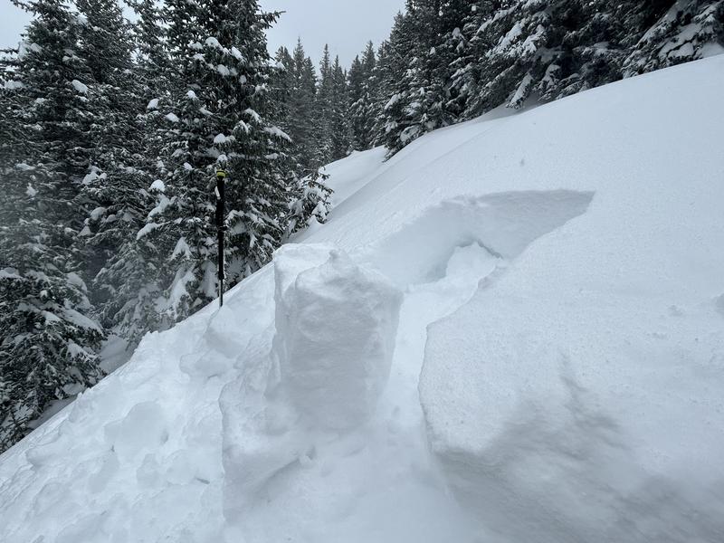
Heavy snowfall and strong winds have created dangerous avalanche conditions.
The avalanche danger is CONSIDERABLE on all aspects above treeline, and on steep slopes facing NW-NE-SE near treeline. Human triggered avalanches involving new and wind drifted snow are likely. Avalanches could break up to 3' deep or more on wind drifted slopes.

The danger is MODERATE on all other aspects and elevations and human triggered avalanches are possible, with the greatest likelihood occurring on steep, wind, drifted slopes.

Backcountry travelers need to have good route finding and snow stability analysis skills. Seek low angle, sheltered terrain for the best and safest skiing and riding today.
Low
Moderate
Considerable
High
Extreme
Learn how to read the forecast here
Special Announcements
Geyser Pass Road: Grand County will be plowing the road today and the gate will be closed while work is in progress.
Grooming: Trails are covered in new snow.
Weather and Snow
6:00 a.m. Snow and Weather Data
24 Hour Snow 4?" 72 Hour Snow 23?" Season Total Snow 280" Base Depth at Gold Basin 103"
Winds on Pre-Laurel Peak: N/A Temp 28˚ F

Weather
A broad low pressure trough is parked over the Western U.S. keeping us under unsettled and breezy conditions. We may get a glimpse of some partly sunny skies today before an increasing chance of light snow showers develops this afternoon. SW winds will blow in the 10-15 mph range with higher gusts along ridge tops. High temps will be in the low to mid 20's. Unsettled weather will continue through the weekend and possibly even into early next week as lingering moisture and a series of disturbances move though the region.

General Conditions
Confusing and intermittent data has made it hard to know exactly how much snow we have received, especially in the last 24 hours. SNOTEL sites report anywhere from 0.6"-1.1" of Snow Water Equivalent (SWE) but with only a few inches of accumulated snow. The Gold Basin storm stake is showing 20" of snow since Monday, so with settlement, it's safe to say we've received upwards of 2' of snow since then. Pre Laurel winds are also down, but San Juan stations yesterday showed SW winds blowing in the 30-40 mp range with gusts at Telluride reaching 70 mph. Travelers yesterday reported drifts 3'-4' deep across the Geyser Pass road, so in spite of the lack of hard data, it's clear that heavy snowfall and strong winds have created dangerous avalanche conditions out there.

Snowpack and Weather Data
Gold Basin Storm Stake (10,000')
Gold Basin SNOTEL site (10,000')
SNOTEL site near Geyser Pass Winter Trailhead (9600')
Wind Station on Pre-Laurel Peak (11,400')
NWS forecast for the La Sal Mountains.
Recent Avalanches
View the La Sal avalanche database here.
Ad
Avalanche Problem #1
Wind Drifted Snow
Type
Location
Likelihood
Size
Description
Unstable slabs of wind drifted snow are the primary concern. The greatest danger will be on steep, northerly aspects, but with such strong winds you can expect to encounter sensitive slabs of wind drifted snow on all aspects today, even at lower elevations in exposed terrain. The danger will increase and become more widespread with elevation. Wind drifted slopes might appear as "fat," rounded, or pillowy and cracking is a sign of instability.
Skiers and riders should avoid all steep slopes that have been recently loaded with wind drifted snow.
Avalanche Problem #2
New Snow
Type
Location
Likelihood
Size
Description
We've picked up a lot of dense, heavy snow this week, and soft slab avalanches involving the new snow are possible on all aspects and elevations today. Temperature changes throughout the stormy period have created density inversions within the recent snow creating several potential sliding surfaces. In your travels, pay attention to how the snow is behaving. Dig down with your hand and look for lower density snow underneath soft slabs of heavier. Look for blocks between your skis, and of course cracking in the snow surface. Utilize inconsequential terrain as a "test slope" to see how the snow is behaving. If you lack these stability analysis skills, avoid all slopes steeper than 30 degrees until the recent snow has had time to stabilize.
In his travels Monday, Dave observed soft slab conditions in the new snow. See the photo below for an example of what this looks like.
General Announcements
This forecast is from the U.S.D.A. Forest Service, which is solely responsible for its content. This forecast describes general avalanche conditions and local variations always occur. This forecast will be updated by 7:30 tomorrow morning.