Forecast for the Moab Area Mountains

Dave Garcia
Issued by Dave Garcia for
Wednesday, March 22, 2023
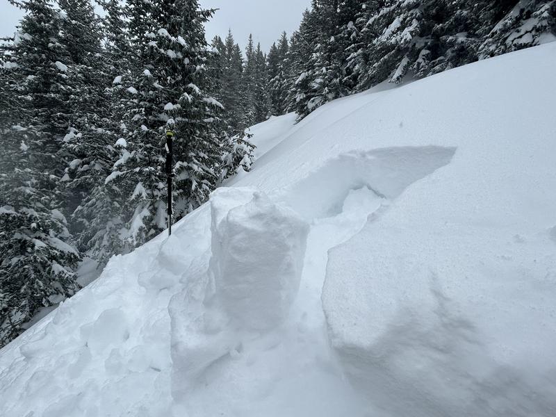
Very dangerous avalanche conditions exist in the backcountry today.
HIGH avalanche danger exists on leeward slopes above treeline. Natural and human triggered avalanches up to three feet deep are VERY LIKELY on wind loaded slopes above treeline. Backcountry travelers will also encounter unstable slabs of wind drifted snow near treeline, where the danger is CONSIDERABLE. Out of the wind zone, you'll find a MODERATE avalanche danger where both dry loose and soft slab avalanches involving the new snow are POSSIBLE.
Seek low angle, sheltered terrain for the best and safest skiing and riding today.
Low
Moderate
Considerable
High
Extreme
Learn how to read the forecast here
Special Announcements
Geyser Pass Road: The road did not get plowed yesterday, expect travel to be difficult. 4x4 required, chains recommended.
Grooming: Trails will be covered in new snow.
Weather and Snow
6:00 a.m. Snow and Weather Data
24 Hour Snow 5?" 72 Hour Snow 19?" Season Total Snow 276" Base Depth at Gold Basin 100"
Winds on Pre-Laurel Peak: N/A Temp 28˚ F

Weather
Snowfall will continue today and it looks like the mountains will pick up another 3-6" of snow. Strong SW winds will blow 30-35 mph with gusts up to 55 mph. Overnight the winds will back off some, and snow showers will diminish. There will be a break in the action tomorrow morning. Light snow showers return Thursday afternoon and the pattern stays active for Friday and Saturday.
General Conditions
Mountain weather stations are giving me some trouble this morning, and I can only guess snow totals and wind speeds up on Pre-Laurel. I'm reading 0.5" of water at Gold Basin in 24 hours and it seems reasonable to assume 5 inches of new snow fell in that period. Winds were forecast to gust to 70 overnight out of the SW. Telluride ski area saw gusts between 60-80 overnight, so it is safe to assume very strong SW winds blew in the La Sals as well. This puts our storm totals at about 2.0" of water and almost 20 inches of snow since Sunday night. With such strong winds, you will want to seek sheltered terrain for the best skiing today. Strong winds will have penetrated into the mid-elevation bands and you will find fresh, sensitive slabs of wind drifted snow near treeline and above. The avalanche danger is high, and human triggered avalanches are very likely on Northerly facing slopes that have been drifted in. Human triggered avalanches involving new snow remain possible on all steep slopes today.

Snowpack and Weather Data
Gold Basin Storm Stake (10,000')
Gold Basin SNOTEL site (10,000')
SNOTEL site near Geyser Pass Winter Trailhead (9600')
Wind Station on Pre-Laurel Peak (11,400')
NWS forecast for the La Sal Mountains.
Recent Avalanches
View the La Sal avalanche database here.
Ad
Avalanche Problem #1
Wind Drifted Snow
Type
Location
Likelihood
Size
Description
In my travels on Monday I observed active snow transport forming deep drifts on Northerly aspects. Additional snowfall overnight and strong winds have formed fresh drifts on these same slopes. Expect to find large areas of wind drifted snow up to three feet deep on leeward slopes.
The greatest danger will be on Northerly aspects, but with such strong winds you can expect to encounter sensitive slabs of wind drifted snow on all slopes above treeline. Additionally, leeward slopes near treeline get in on the action today and backcountry travelers can expect to find unstable slabs of wind drifted snow further down slope than you might typically expect.
Skiers and riders should avoid all steep slopes that have been recently loaded with wind drifted snow. These slopes will appear fat, round, and pillowy.
Avalanche Problem #2
New Snow
Type
Location
Likelihood
Size
Description
During my tour on Monday I found the new snow had formed a cohesive slab. The snow was cracking beneath my skis and the overlying slab was poorly bonded to the old snow, especially on Northerly aspects. Blocks of snow pulled out easily in hand shear tests all day long. Snowfall will continue today and soft slab avalanches and dry loose avalanches in the new snow remain possible. If we see periods of heavy snowfall this morning, this problem will become more sensitive. Use test slopes to see how the new snow is reacting.
On Monday it was very easy to pull out cohesive blocks of snow. The storm slab is poorly bonded to the old snow surface on this North facing slope.
Additional Information
Thanks to everyone who made it out the Banff Film Festival this weekend. We had an awesome turnout and a great selection of movies was shown.
General Announcements
This forecast is from the U.S.D.A. Forest Service, which is solely responsible for its content. This forecast describes general avalanche conditions and local variations always occur. This forecast will be updated by 7:30 tomorrow morning.