Forecast for the Moab Area Mountains

Dave Garcia
Issued by Dave Garcia for
Tuesday, March 21, 2023
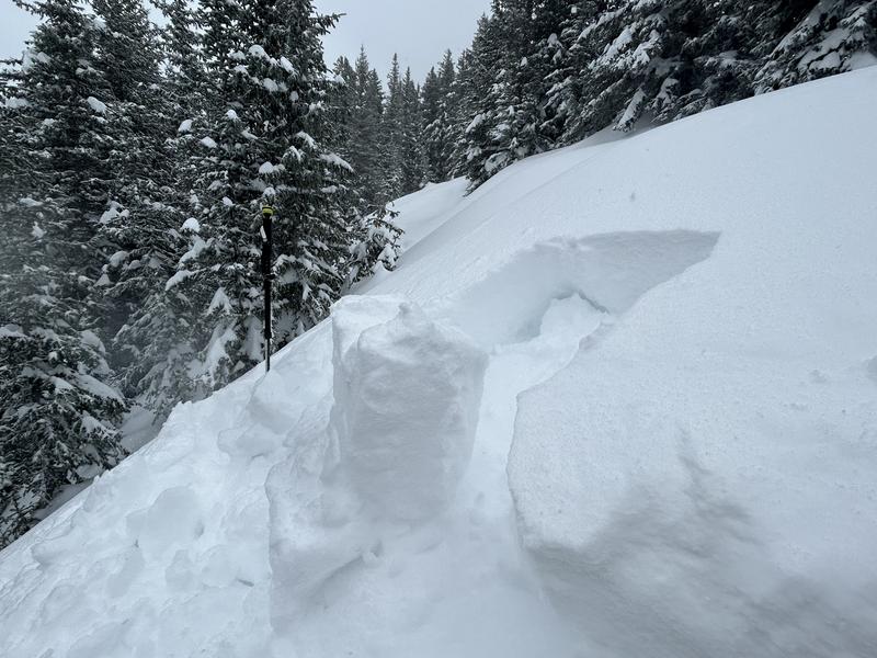
Strong winds and heavy snowfall have created a CONSIDERABLE avalanche danger in the mountains. Human triggered avalanches are LIKELY today in both new and wind drifted snow. Backcountry travelers should expect to encounter sensitive wind drifts on all slopes above treeline and slopes near treeline that face W-N-E. Storm slab and dry loose avalanches will become LIKELY as more snow stacks up throughout the day.
Backcountry conditions are much more dangerous than they were this weekend. It is time to dial it back and use cautious route finding and conservative decision making.
Low
Moderate
Considerable
High
Extreme
Learn how to read the forecast here
Special Announcements
Geyser Pass Road: Plow crews will eventually get to Geyser Pass Road today after plowing residential areas. Expect the Geyser Pass Road to close at some point this morning. If you are ahead of the plow, travel will be difficult with deep drifts.
Grooming: Trails were last groomed on Friday.
Weather and Snow
6:00 a.m. Snow and Weather Data
24 Hour Snow 11" 72 Hour Snow 14" Season Total Snow 271" Base Depth at Gold Basin 99"
Winds on Pre-Laurel Peak: N/A Temp 15˚ F

Weather
Things are quiet this morning for a short window before the next wave of the atmospheric river moves through the La Sals. Snow will begin around noon and will be heavy at times. Southerly winds will start out around 10-15 mph and increase to 20-25. We could see gusts up to 40 mph today. The heaviest period of snow will occur overnight into Wednesday. Snowfall rates overnight could be 2 inches an hour. During the peak of the storm, winds will blow 30-40 mph out of the SW, with gusts up to 70 mph. By noon tomorrow, we could stack up another 12-18" of snow. The pattern remains active with chances for more snow through the weekend.
General Conditions
The calendar says it's time for sunglasses and skiing big lines, but mother nature says otherwise. It is full-on winter in the La Sal Range. The first wave of this AR event dropped 14" of snow at 2.1" of SWE. This made for excellent surfy pow conditions, but all of this snow comes with increasing avalanche danger. Dangerous avalanche conditions exist, and human triggered avalanches are likely, involving both new and wind drifted snow. The danger will be on the rise when the next wave of snow moves in around noon. The heaviest snowfall is forecast to occur overnight, but if heavy PI rates occur during the day, expect a corresponding rise in danger. If you have been getting into big terrain lately, it is certainly time to dial it back and keep things conservative.

Snowpack and Weather Data
Gold Basin Storm Stake (10,000')
Gold Basin SNOTEL site (10,000')
SNOTEL site near Geyser Pass Winter Trailhead (9600')
Wind Station on Pre-Laurel Peak (11,400')
NWS forecast for the La Sal Mountains.
Recent Avalanches
View the La Sal avalanche database here.
Ad
Avalanche Problem #1
Wind Drifted Snow
Type
Location
Likelihood
Size
Description
In my travels yesterday I observed active snow transport all day long. That trend continued overnight, building thick slabs of wind drifted snow up to two feet deep. The greatest danger and deepest drifts will be most pronounced on Northerly facing slopes, but backcountry travelers should expect to find fresh drifts on all slopes above treeline. Wind slabs often form on the lee side of exposed ridges and in and around terrain features. Watch for and avoid drifts on gully walls, under cliff bands, along sub-ridges, in scoops, saddles, and sinks. Keep in mind that wind slabs will continue to form throughout the day, and freshly formed wind slabs can be quite sensitive and are often remotely triggered.
Backcountry travelers should avoid all steep slopes that have been recently loaded with wind drifted snow. These slopes will appear fat, round, and pillowy.
Avalanche Problem #2
New Snow
Type
Location
Likelihood
Size
Description
During my tour yesterday I found the new snow had formed a cohesive slab. The snow was cracking beneath my skis and the overlying slab was poorly bonded to the old snow, especially on Northerly aspects. Blocks of snow pulled out easily in hand shear tests all day long. With another round of heavy snow starting again mid day, you should expect a rising instability within the storm snow. Both storm slab avalanches and dry loose avalanches are possible in steep terrain on all aspects this morning. If we see heavy snowfall rates during the day, human triggered avalanches within the new snow will become likely. Use steep test slopes to see how the storm snow is reacting.
Yesterday it was very easy to pull out cohesive blocks of snow. The storm slab is poorly bonded to the old snow surface on this North facing slope.
Additional Information
Thanks to everyone who made it out the Banff Film Festival this weekend. We had an awesome turnout and a great selection of movies was shown.
General Announcements
This forecast is from the U.S.D.A. Forest Service, which is solely responsible for its content. This forecast describes general avalanche conditions and local variations always occur. This forecast will be updated by 7:30 tomorrow morning.