Join us at our 2nd Annual Blizzard Ball

Forecast for the Moab Area Mountains

Mark Staples
Issued by Mark Staples on
Saturday morning, March 23, 2024
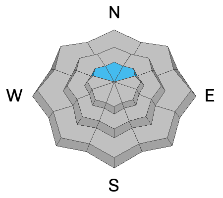
The avalanche danger today is LOW, but conditions are changing. Clouds should limit sunshine from heating the snow and creating any wet snow avalanche concerns. Increasing winds from the south should create shallow slabs of wind drifted snow to watch for and avoid.
Low
Moderate
Considerable
High
Extreme
Learn how to read the forecast here
Special Announcements
Road Conditions: The Geyser Pass Road was plowed on Monday 3/18 and should be pretty wet and muddy today.
Grooming: The last grooming was on Wednesday and conditions have gotten a bit rough.
Support the UAC website backend platform rebuild to ensure the ongoing security of the website and the data stored on the site rebuild by donating to our spring campaign. Save lives by making a donation today! HERE

Thanks to everyone who attended the amazing films of the Banff Film Festival the last two nights!
Weather and Snow
6:00 a.m. Snow and Weather Data
24 Hour Snow 0" 72 Hour Snow 0" Season Total Snow 168" Depth at Gold Basin 59"
Winds on Pre-Laurel Peak: S 20-35 mph Temp 24° F Percent of Normal: 115%

Weather
The jetstream over Arizona and New Mexico will be sending moisture and winds into southern Utah again. Winds shifted direction yesterday afternoon and began blowing from the S. They will increase this afternoon blowing 30-40 mph. Temperatures this morning are starting about 5 degrees warmer than yesterday, and they should climb into the upper 30s today. Clouds are already approaching the 4 Corners region this morning and will build all day with some snowfall but no accumulations. Snow should start to accumulate this evening and produce about 3-6 inches of snow by tomorrow morning with more falling through the day. The NWS is calling for 6-10 inches tonight...let's hope they're right!
Temperatures should be much colder tomorrow as the jetstream movess over the U.S./Mexco border and cold air descends over much of the western U.S. Weather will remain unsettled in the first part of the week with a break midweek as a brief ridge moves over Utah. By the end of the week, a similar pattern sets up with the jetstream dropping to the south and possibly sending more moisture into southern Utah.
General Conditions
It's typical March conditions when the strong spring sunshine has a strong effect. Tim and Lance reported every possible snow condition yesterday but still found nice dry powder on upper elevation N and NW aspects. They provide a great overall summary of snow and avalanche conditions in their ob HERE. Sam Van Wetter found similar conditions on Thursday.
In spotty locations near treeline on northerly facing slopes, there is a very obvious faceted layer buried about 2 feet deep. This layer has only produced one avalanche eleven days ago and would be something to look for or consider after descending from upper elevations into steeper, partially open slopes near treeline.
Eric gives a great summary of past conditions in the video below.
Snowpack and Weather Data
Gold Basin Storm Stake (10,000')
Gold Basin SNOTEL site (10,000')
SNOTEL site near Geyser Pass Winter Trailhead (9600')
Wind Station on Pre-Laurel Peak (11,400')
NWS forecast for the La Sal Mountains.
Recent Avalanches
Warm temperatures and strong sunshine has melted the surface snow layers and caused some minor loose wet avalanches or wet sluffs mostly on west facing slopes near rocks that absorb extra heat.
New snow and wind about a week ago created an avalanche cycle of widespread soft slab avalanches; however, there were two repeat running avalanche paths failed on basal facets near the ground including this avalanche in Horse Creek. Eric describes it well in the video above.
Ad
Avalanche Problem #1
Wind Drifted Snow
Type
Location
Likelihood
Size
Description
Increasing winds from the south today will be doing their best to find some snow to move around at upper elevation northerly facing terrain. Any soft slabs of this wind drifted snow will be shallow today because there is limited snow for them to transport, but heads up for tomorrow when they should be more of a threat. Otherwise, most of the older wind slabs from last weekend should have stabilized by now.
Additional Information
Want some more insight into the La Sal Mountains as well as the communal impacts of a tragic avalanche? Check out the latest UAC podcast with forecaster Eric Trenbeath where he discusses the range, it's often treacherous snowpack, and how the devastating avalanche in February, 1992, affected the Moab community.
Our avalanche beacon checker sign and beacon training park are up and running. A huge thanks to Talking Mountain Yurts for sponsoring those this season!
Sign up for forecast region-specific text message alerts. You will receive messages about changing avalanche conditions, watches, warnings and road plowing closures.
Follow us on Instagram @utavy_moab
General Announcements
This forecast is from the U.S.D.A. Forest Service, which is solely responsible for its content. This forecast describes general avalanche conditions and local variations always occur.