UDOT PLANNED AVALANCHE CLOSURES!!

Forecast for the Moab Area Mountains

Eric Trenbeath
Issued by Eric Trenbeath for
Monday, March 21, 2022
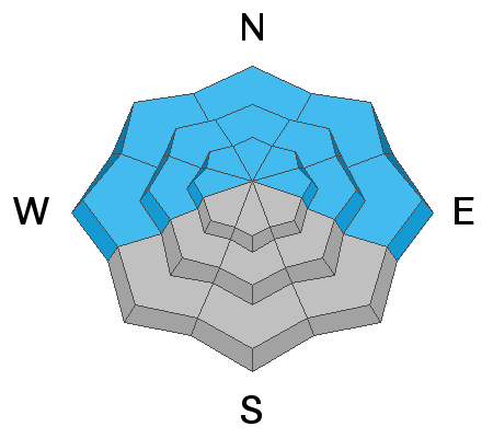
Areas of CONSIDERABLE avalanche danger exist above treeline where strong, gusty, northerly winds will create fresh, unstable drifts on all aspects today. Although S and W facing slopes are the primary deposition zones, crossloading will cause fresh drifts to form on all aspects. Look for them on the leeward sides of ridge crests and terrain features such as gully walls and subridges. Fresh drifts are recognizable by their smooth rounded appearance and cracking is a sign of instability. The danger should decrease with elevation but remain vigilant and avoid steep, wind drifted slopes.
A "scary" MODERATE danger remains for triggering a deadly avalanche 2'-3' deep on a buried persistent weak layer. This weak layer is present on all slopes facing W-N-E and has been responsible for accidents and fatalities throughout the region. These avalanches can be triggered at all elevations but areas of heightened concern are on steep, northerly facing slopes right around treeline. Evaluate snow and terrain carefully and identify features of concern.
Low
Moderate
Considerable
High
Extreme
Learn how to read the forecast here
Special Announcements
Please help support avalanche forecasting throughout Utah. Donate to the Spring Campaign to help raise the funds to support the forecasting you rely on.
Road Conditions: The road is a mix of dirt, mud, and patches of packed snow. It gets sloppier as the days warm up. All wheel drive and good tires are recommended.
Grooming: Trails will be covered in fresh snow today. No grooming is scheduled.
Weather and Snow
6:00 a.m. weather data:
24 Hour Snow 7" 72 Hour Snow 7" Base Depth at Gold Basin 62" Wind NE 20-30 G45 Temp 27F
The good news is we got snow! The bad news is it's gonna blow. A deep trough centered over the 4 Corners has given us a surprise shot of snow that has exceeded expectations. After the passage of the cold front, northerly winds are going to crank up and we'll see blustery conditions throughout the day and continuing tomorrow. Mostly cloudy skies this morning should gradually clear out by mid-day. High temps will be in the low to mid 30's. The rest of the week will see a dry and steadily warming trend with a veritable heat wave by the weekend.
Snowpack
Gusty northerly winds today will blow and drift the new snow on to all aspects. Though S and W facing slopes will be the prime deposition zones, cross loading will create fresh drifts on the leeward sides of terrain features such as gully walls and sub-ridges on all aspects. Fresh drifts will be recognizable by their smooth, rounded appearance, and cracking is a sign of instability. Avoid steep, wind drifted slopes today.
The buried persistent weak layer of faceted snow that formed during the Jan-Feb high pressure remains the primary concern and it is still capable of producing dangerous, human triggered avalanches over two feet deep on all slopes facing the north side of the compass.
Snow and Weather Links
Gold Basin SNOTEL site (10,000')
Storm Totals in Gold Basin
Wind Station on Pre Laurel Peak (11,700')
Recent Avalanches
I'm sorry to report another avalanche fatality in Colorado. This one involved two skiers north of Steamboat Springs. Here is the preliminary report.
On Thursday, a lone snowboarder was killed in an avalanche in the neighboring San Juan Mountains of Colorado, near Trout Lake on a steep, rocky, NW facing slope. Here is the preliminary report.
Skiers and riders also continue to trigger avalanches in Northern Utah. We have a similar snowpack as these other regions. The only thing preventing accidents down here are fewer numbers and the so far relative restraint of the users. My conversations with you all in the parking lot have been heartening. Thank you for your awareness and for keeping it dialed back.
Ad
Avalanche Problem #1
Persistent Weak Layer
Type
Location
Likelihood
Size
Description
A persistent weak layer of loose, sugary faceted snow exists on W-N-E aspects beneath a slab that is 2' -3' thick. The weakest snow can be found on northerly aspects right around treeline and below. Above treeline the weak layer distribution is much more variable and it is hard to track. Stability test show that avalanches are becoming harder to trigger on this weak layer, but the bottom line is that attempting to outsmart this avalanche problem is a dangerous proposition. Likely trigger points include areas of shallow snow, slope margins, rocky outcroppings, and steep convex roll overs. If you are of the mindset to begin creeping into avalanche terrain keep in mind that signs of instability will no longer be obvious but that is not necessarily an indication of stability.
Avalanche Problem #2
Wind Drifted Snow
Type
Location
Likelihood
Size
Description
Gusty northerly winds today will form fresh wind drifts 12"-24" deep. Although S and W facing slopes are the primary deposition zones, cross loading will allow drifts to form on northerly facing slopes as well. Be on the look out for unstable wind slabs on the leeward sides of ridge crests and terrain features such as sub ridges, gully walls, and rock outcrops. Fresh drifts will added complexity to our already tricky snowpack, and if triggered they could lead to the release of a deeper slab on the buried persistent weak layer. Recent drifts are recognizable by their smooth rounded appearance and they may sound hollow underneath. Scalloped or rippled surfaces are also signs of wind loading. Avoid steep slopes where you can detect recent deposits of wind drifted snow.
General Announcements
Who's up for some free avalanche training? Get a refresher, become better prepared for an upcoming avalanche class, or just boost your skills. Go to https://learn.kbyg.org/ and scroll down to Step 2 for a series of interactive online avalanche courses produced by the UAC.
This forecast is from the U.S.D.A. Forest Service, which is solely responsible for its content. This forecast describes general avalanche conditions and local variations always occur.