Forecast for the Moab Area Mountains

Eric Trenbeath
Issued by Eric Trenbeath for
Saturday, March 2, 2019
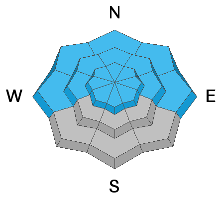
Look for a rising avalanche danger over the next 24 hours! The avalanche danger is MODERATE this morning but will likely rise to CONSIDERABLE as new snow begins to accumulate. Look for fresh wind drifts to form on the leeward sides of upper elevation ridge crests and terrain features, primarily on slopes facing NW-N-E. If we see more than about 6" of snow today, human triggered avalanches within the new snow will be possible on all aspects. Cracking in the snow surface is a sign of instability. There also remains an isolated, or MODERATE danger for human triggered avalanches involving a buried, persistent weak layer. You are most likely to encounter this problem on steep, rocky, northerly facing slopes, or in areas with a shallower snowpack. Backcountry travelers today need to be alert to changing conditions and adjust their plans accordingly.
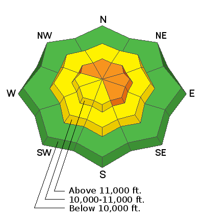
Low
Moderate
Considerable
High
Extreme
Learn how to read the forecast here
Special Announcements
We're offering a Motorized Backcountry 101 course through Backcountry Institute on March 22, 23 to be held in Monticello, and Dark Canyon in the La Sal Mountains. Click here for more information and to register.
Weather and Snow
Skies are cloudy, WSW winds are averaging 15-20 mph along ridge tops with gusts to 30, and temps are in the low to mid 20's. Sound like the same old spiel? Never fear, winter will return to the mountains today as a moist storm system moves through the region. Snowfall should begin mid morning with the greatest intensity occurring this afternoon and evening. Snowfall rates of 1"-2" an hour are likely, and it looks like we could see a foot or more of snow by tomorrow. WSW winds will continue to blow in the moderate range, and daytime highs will be around 30 degrees.
A variety of snow surfaces exist out there right now, but conditions will improve as the day progresses. Dave Garcia and Nate Ament were out and about in Gold Basin yesterday, read about their travels here.
New snow totals in Gold Basin (10,000')
Snotel totals at the Geyser Pass Trailhead (9600') y
Wind, temperature, and humidity on Pre Laurel Peak (11,700')
National Weather Service point forecast.
Ad
Avalanche Problem #1
Wind Drifted Snow
Type
Location
Likelihood
Size
Description
Look for the development of fresh deposits of wind drifted snow as the day progresses and snow starts to accumulate.You are most likely to find these drifts on the leeward sides of ridge crests and terrain features in upper elevation terrain that faces NW-N-SE. You can recognize them by their smooth, rounded appearance. Cracking, in the snow surface is a sign of instability. Avoid steep slopes with recent deposits of wind drifted snow.
Avalanche Problem #2
Persistent Weak Layer
Type
Location
Likelihood
Size
Description
It's becoming harder to trigger an avalanche down to a buried persistent weak layer, but if you did it would be large and dangerous. Areas with a shallower snowpack are the most suspect and this includes slopes that have already avalanched, or that have been previously wind scoured. Steep, rocky slopes facing N-NE-E have been the most active, but weak snow and poor test results are still being encountered on SE facing slopes. Careful snow stability analysis is essential, and the bottom line is that local observers and I are going to continue to avoid slopes steeper than 35 degrees, especially those with a northerly aspect.
Avalanche Problem #3
New Snow
Type
Location
Likelihood
Size
Description
If we end up with more than about 6" today, we may start to see avalanching within the new snow. Watch how the new snow is bonding to the old snow surface, and observe whether or not it is forming a cohesive slab. Loose snow sluffing, and cracking in the snow surface are signs of instability within the new snow. Avoid steep slopes if these signs are present, and stay out from under high, steep faces, especially those with and easterly component, where natural avalanches from above may release within the new snow.
Additional Information
Check out this clip of local Moab sledders playing it safe and making sure their beacons are on at the Geyser Pass Trailhead.
General Announcements
Your information can save lives. If you see anything we should know about, please help us out by submitting snow and avalanche observations HERE. You can also call me at 801-647-8896, or send me an email: [email protected].
Support the UAC through your daily shopping. When you shop at Smith's, or online at REI, Backcountry.com, Patagonia, NRS, Amazon, eBay by clicking on these links, they donate a portion of your purchase to the UAC. If you sell on eBay, you can have your See our Affiliate Page for more details on how you can support the UAC when you shop
This advisory is from the U.S.D.A. Forest Service, which is solely responsible for its content. This advisory describes general avalanche conditions and local variations always occur.