Forecast for the Moab Area Mountains

Eric Trenbeath
Issued by Eric Trenbeath for
Friday, March 1, 2019
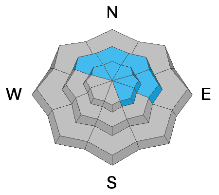
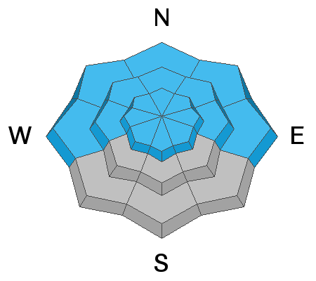
The avalanche danger is MODERATE, and human triggered avalanches involving wind drifted snow, and buried, persistent weak layers, are possible. The greatest likelihood for triggering an avalanche exists on steep, wind drifted, slopes, right around treeline and above, that face NW-NE-E. The greatest danger for avalanches involving buried persistent weak layers also exists on steep, northerly facing terrain, especially on rocky, radical, or sparsely treed slopes where the snowpack is shallow and weak. Slide paths that have already run, and then filled back in are also suspect.
Low
Moderate
Considerable
High
Extreme
Learn how to read the forecast here
Special Announcements
We're offering a Motorized Backcountry 101 course through Backcountry Institute on March 22, 23 to be held in Monticello, and Dark Canyon in the La Sal Mountains. Click here for more information and to register.
Weather and Snow
A trace of snow has fallen overnight, southwesterly ridge top winds continue to blow in the 20-25 mph range with gusts to 40, and 10,000' temps are in the mid 20's. Today we'll see cloudy skies and and a chance for scattered showers. SW winds will continue to blow in the moderate to strong range, and high temps will be right around freezing. Saturday's storm is starting to look better for us with snow falling through the day and into the night. 6"-10" are possible.
The glory days of last weekend are gone and the snow surface is getting a bit tired after several days of wind and warm temperatures. Look to wind sheltered, northerly facing terrain for soft snow.
New snow totals in Gold Basin (10,000')
Snotel totals at the Geyser Pass Trailhead (9600') y
Wind, temperature, and humidity on Pre Laurel Peak (11,700')
National Weather Service point forecast.
Ad
Avalanche Problem #1
Wind Drifted Snow
Type
Location
Likelihood
Size
Description
Continuous, moderate to strong SW winds have likely managed to etch through crusted over south faces, and drift snow on to northerly aspects. Most of theses recent wind slabs will be stiff, and shallow, but if you triggered one in the high country it could take you for a ride. Older, deeper drifts still exist on northerly aspects as well, and though most are now welded in to place, give pause to any steep slope that has a smooth rounded appearance and consider the consequences. A triggered deep wind drift also has the potential to step down into a buried persistent weak layer causing a deeper and more dangerous avalanche.
Avalanche Problem #2
Persistent Weak Layer
Type
Location
Likelihood
Size
Description
It's becoming harder to trigger an avalanche down to a buried persistent weak layer, but if you did it would be large and dangerous. Areas with a shallower snowpack are the most suspect and this includes slopes that have already avalanched, or that have been previously wind scoured. Steep, rocky slopes facing N-NE-E have been the most active, but weak snow and poor test results are still being encountered on SE facing slopes. Careful snow stability analysis is essential, and the bottom line is that local observers and I are going to continue to avoid slopes steeper than 35 degrees, especially those with a northerly aspect.
Additional Information
Check out this clip of local Moab sledders playing it safe and making sure their beacons are on at the Geyser Pass Trailhead.
General Announcements
Your information can save lives. If you see anything we should know about, please help us out by submitting snow and avalanche observations HERE. You can also call me at 801-647-8896, or send me an email: [email protected].
Support the UAC through your daily shopping. When you shop at Smith's, or online at REI, Backcountry.com, Patagonia, NRS, Amazon, eBay by clicking on these links, they donate a portion of your purchase to the UAC. If you sell on eBay, you can have your See our Affiliate Page for more details on how you can support the UAC when you shop
This advisory is from the U.S.D.A. Forest Service, which is solely responsible for its content. This advisory describes general avalanche conditions and local variations always occur.