Forecast for the Moab Area Mountains

Eric Trenbeath
Issued by Eric Trenbeath for
Thursday, March 16, 2023
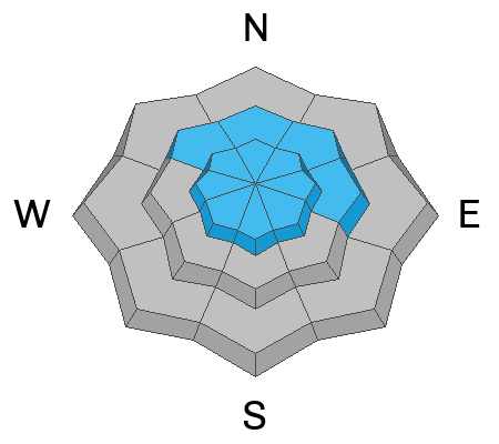
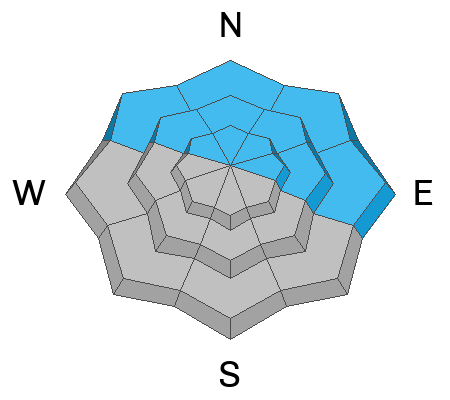
The avalanche danger is CONSIDERABLE on all steep slopes near and above treeline. Dense, heavy snow and strong winds have created dangerous avalanche conditions and human triggered avalanches involving slabs of recent and wind drifted snow are likely.

Below treeline, the avalanche danger is MODERATE and human triggered avalanches are possible.

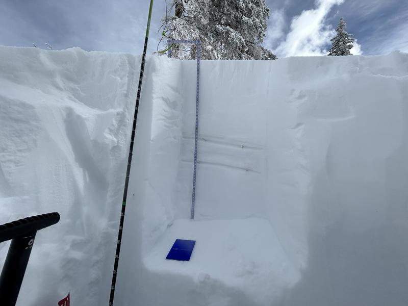
Backcountry travelers today need to have good route finding and snow stability analysis skills.
Low
Moderate
Considerable
High
Extreme
Learn how to read the forecast here
Special Announcements
The Banff Centre Mountain Film Festival World Tour is coming to Moab March 17-18. For tickets and information go here.
Geyser Pass Road: Grand County will be plowing this morning and the gate will be closed while work is in progress.
Grooming: Trail grooming will commence sometime today or tomorrow and should be good to go by the weekend.
Weather and Snow
6:00 a.m. Snow and Weather Data
24 Hour Snow 10" 72 Hour Snow 10" Season Total Snow 257" Base Depth at Gold Basin 94"
Winds on Pre Laurel Peak NA Temp 21

Weather
The storm has largely moved on and winds have swung around to the NW. Today look for diminishing clouds with skies becoming partly to mostly sunny as the day progresses. Ridge top NW winds will blow in the 15-20 mph range and high temps will be in the low 20's. Under clear skies tonight, temps will drop down into the single digits. High pressure over the Great Basin builds Friday bringing clear skies through Saturday. By Monday, well start to see the effects of yet another Atmospheric River that will impact the area through mid next week.

General Conditions
8"-10" of heavy, wet snow has fallen with more than 1.5" to 1.75" of Snow Water Equivalent. Under normal temperatures/conditions this would translate to 15"-18" of new snow. Ridge top SW winds during the day yesterday blew in the 15-25 mph range. Though not totally out of hand, these are perfect speeds for blowing and drifting snow on to northerly aspects. A change in direction today will cause fresh drifts to from on southerly aspects at upper elevations. Soft slab avalanches will be possible to likely in the most recent snow on steep slopes on all aspects today. The danger will be greatest on steep, wind drifted, northerly aspects and these areas should be avoided. On all other aspects you'll need to assess how the new snow is behaving. Look for signs of instability such as cracking in the snow surface and see if the new snow has slab-like properties before committing to steeper terrain. If you don't have good stability analysis skills, your safest bet today is to avoid slopes steeper than 30 degrees.
To see all La Sal observations click here

Snowpack and Weather Data
Gold Basin Storm Stake (10,000')
Gold Basin SNOTEL site (10,000')
SNOTEL site near Geyser Pass Winter Trailhead (9600')
Wind Station on Pre-Laurel Peak (11,400')
NWS forecast for the La Sal Mountains.
Recent Avalanches
There have been no recent avalanches. See the La Sal avalanche database here.
Ad
Avalanche Problem #1
New Snow
Type
Location
Likelihood
Size
Description
Peak instability within the most recent storm snow likely occurred sometime last evening, but with more than 1.5" of water weight, and 10" of dense, wind driven snow, we're going to want to give things a little more time to adjust. Human triggered avalanches are possible to likely within the most recent snow especially in areas that have been affected by the wind. Pay close attention to how the new snow is behaving. Look for signs of instability such as cracking in the snow surface, or slab like blocks between your skis on the skin trail. A shovel tilt test can give you an idea how well the new snow is bonding to the old snow surface. Any steep, wind drifted slope should be avoided and careful stability analysis is required in other terrain. Safest bet today is to avoid slopes steeper than 30 degrees.
Avalanche Problem #2
Wind Drifted Snow
Type
Location
Likelihood
Size
Description
SW winds yesterday blew and drifted the most recent snow on to northerly aspects near and above treeline and these areas should be avoided. A wind shift to the NW will cause fresh drifts to form on southerly aspects today. Look for fresh, unstable slabs of wind drifted snow on the leeward sides of ridge crests and terrain features such as gully walls and sub-ridges and avoid slopes steeper than 30 degrees that have fresh deposits of wind drifted snow.
Avalanche Problem #3
Persistent Weak Layer
Type
Location
Likelihood
Size
Description
Weak interfaces exist in the top meter of the snowpack on some slopes with a Northerly component to their aspect. In our travels we have observed these layers gaining strength. These weak interfaces did not react to stability testing on Monday and Tuesday. On Tuesday, Dave ventured in to steeper terrain on northerly aspects with confidence. However, a good strategy for the short term is to let this storm pan out, and see how these layers react to a new load. This storm could reawaken these weak layers, especially in areas that may become heavily drifted. Travel advice during the storm is to avoid steep slopes that harbor these buried weak layers.
Two weak interfaces are easily seen in this photo. In this pit, the 2/22 interface is down 53cm and the 2/14 interface is down 69cm.
General Announcements
This forecast is from the U.S.D.A. Forest Service, which is solely responsible for its content. This forecast describes general avalanche conditions and local variations always occur. This forecast will be updated by 7:30 tomorrow morning.