Forecast for the Moab Area Mountains

Dave Garcia
Issued by Dave Garcia for
Wednesday, March 15, 2023
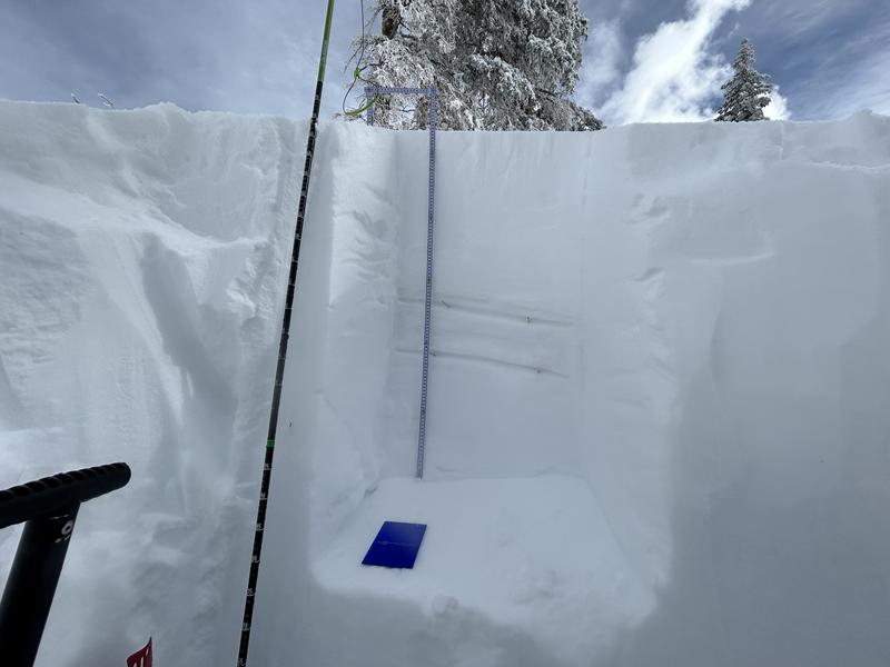
The avalanche danger will rise to CONSIDERABLE today as an atmospheric river event brings heavy snow and strong winds to the mountains. Strong winds will create sensitive slabs of wind drifted snow near treeline and above on slopes that face NW-N-NE-E and human triggered avalanches are LIKELY. On some slopes with a Northerly component to their aspect, deep drifts may form on top of buried weak layers resulting in deeper and more dangerous avalanches.
Instabilities may develop within the new snow during times of peak snowfall rates today. Sluffs and dry loose avalanches may become POSSIBLE on all steep slopes.
Conditions are changing in the mountains. It is time to dial back terrain choices and make conservative decisions.
Low
Moderate
Considerable
High
Extreme
Learn how to read the forecast here
Special Announcements
The Banff Centre Mountain Film Festival World Tour is coming to Moab March 17-18. For tickets and information go here.
Geyser Pass Road: The road is open. 4x4 recommended.
Grooming: Trails are not groomed
Weather and Snow
6:00 a.m. Snow and Weather Data
24 Hour Snow 0" 72 Hour Snow 4" Season Total Snow 247" Base Depth at Gold Basin 84"
Winds on Pre Laurel Peak S 11-15 Temp 13

Weather
Another atmospheric river event is poised to hit the La Sals today. Snow is just beginning to fall as I write this. The mountains should receive about 12 inches of snow and just over an inch of water. Snowfall rates could exceed 1 inch per hour during the day today. Temperatures will be in the upper 20's and SW winds will blow 25-30 mph. Snow showers linger into Thursday morning. Thursday will be cold, with a high of 18 and winds out of the North at 15-25 mph. Look for sunny skies on Friday ahead of the next storm this weekend. Active and unsettled weather is likely to continue next week.

General Conditions
It has been a string of great ski days since Friday's storm dropped 14" and Sunday night added another 4". Today will be a full-on storm skiing day with strong winds and heavy snow. If you are out and about today, sheltered tree skiing will be your best bet. Sensitive wind drifts will be forming throughout the day on Northerly aspects. If snowfall rates exceed 1 inch per hour for an extended period, backcountry travelers should be on the lookout for dry loose avalanches and sluffs in steep terrain. Some weak interfaces still exist on Northerly aspects. Over time, these layers have gained strength, but it is still possible for avalanches to break down to these weaknesses, especially in heavily drifted areas.
To see details of my fieldwork from Monday, click here.
To see all La Sal observations click here

Snowpack and Weather Data
Gold Basin Storm Stake (10,000')
Gold Basin SNOTEL site (10,000')
SNOTEL site near Geyser Pass Winter Trailhead (9600')
Wind Station on Pre-Laurel Peak (11,400')
NWS forecast for the La Sal Mountains.
Recent Avalanches
There have been no recent avalanches. See the La Sal avalanche database here.
Ad
Avalanche Problem #1
Wind Drifted Snow
Type
Location
Likelihood
Size
Description
Fresh, sensitive slabs of wind drifted snow will be actively forming today on leeward sides of ridge crests and terrain features. Expect to encounter fresh drifts near treeline and above, primarily on slopes that face NW-N-NE-E. The greatest danger and deepest drifting will be above treeline. Backcountry travelers should avoid wind drifted slopes that appear fat, rounded, and pillowy.
Avalanche Problem #2
New Snow
Type
Location
Likelihood
Size
Description
New snow instabilities could develop today if PI rates exceed more than 1 inch per hour. Look for a rising danger during times of heaviest snowfall. Sluffs and dry loose avalanches may become possible in steep terrain. The new snow should bond well on Northerly aspects. Solar aspects have a sun crust on the surface, and the new snow may not stick as well on these aspects. Use small test slopes as an indicator of how well the storm snow is bonding to the old surface.
Avalanche Problem #3
Persistent Weak Layer
Type
Location
Likelihood
Size
Description
Weak interfaces exist in the top meter of the snowpack on some slopes with a Northerly component to their aspect. In my recent travels I have observed these layers gaining strength. These weak interfaces did not react to stability testing on Monday and Tuesday. On Tuesday, we pushed into steeper terrain on Northerly aspects with confidence. However, a good strategy for the short term is to let this storm pan out, and see how these layers react to a new load. This storm could reawaken these weak layers, especially in areas that may become heavily drifted. Travel advice during the storm is to avoid steep slopes that harbor these buried weak layers.
Two weak interfaces are easily seen in this photo. In this pit, the 2/22 interface is down 53cm and the 2/14 interface is down 69cm.
General Announcements
This forecast is from the U.S.D.A. Forest Service, which is solely responsible for its content. This forecast describes general avalanche conditions and local variations always occur. This forecast will be updated by 7:30 tomorrow morning.