Sign Up for the Utah Snow and Avalanche Workshop (USAW) on December 7th!

Observation: Laurel Highway

Observation Date
3/13/2023
Observer Name
Garcia
Region
Moab » Laurel Highway
Location Name or Route
Laurel Highway, Laurel Gullies
Weather
Sky
Broken
Wind Direction
Southwest
Wind Speed
Light
Weather Comments
Gorgeous day in the mountains. Sunshine was intermittent, very strong at times.
Snow Characteristics
New Snow Depth
4"
New Snow Density
Low
Snow Surface Conditions
Powder
Melt-Freeze Crust
Snow Characteristics Comments
4 inches of low density powder was the perfect topping for the storm that dropped 14 inches of very heavy snow Friday into Saturday. Great powder skiing on a very supportive base today. Solars got crusted over by the end of the day.
Red Flags
Red Flags
Poor Snowpack Structure
Red Flags Comments
Poor snow structure remains on Northerlies. I was able to locate the faceted layers from 2/22 and 2/14 on a NW aspect today. Both have gained strength, more on this below.
Avalanche Problem #1
Problem
Persistent Weak Layer
Trend
Decreasing Danger
Problem #1 Comments
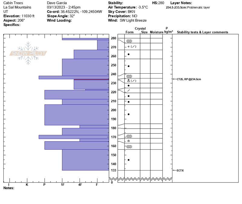
Dug on a SW at 11,030 ft and found a mostly stable snowpack. I got CT25 RP down 42 cm. This failed on a thin layer of Graupel and Decomposing Fragmented grains beneath a crust. An extended column test on this layer produced no results (ECTX). We skied two laps on steep SW slopes in the Laurel Gullies.
Later I dug on a NW aspect at 11,080 ft. to check in on the weak interfaces we have been following for the past month. Today's pit shows both layers gaining strength. A compression test yielded no results on these layers (CTN). The 2/14 layer has gained hardness and the grains show significant rounding. The 2/22 layer also shows signs of rounding (not quite as much as the 2/14 layer). These layers were stressed with almost 2 inches of water weight from Friday's storm. Visibility was good today and no avalanches were observed. The storm advertised for Wednesday looks like another warm, wet event. This will be another good test for these layers. Until then I would still give caution to these weaknesses. Continue to dig down and perform stability tests if you are traveling on Northerly aspects.
In this photo you can see the 2/22 interface down 53cm and the 2/14 interface down 69cm.
Avalanche Problem #2
Problem
Wet Snow
Trend
Same
Problem #2 Comments
Southerly aspects were shedding snow today. I observed roller balls and small loose wet avalanches on slopes facing S, SW, and W.
Today's Observed Danger Rating
Moderate
Tomorrows Estimated Danger Rating
Moderate
Coordinates