Forecast for the Moab Area Mountains

Dave Garcia
Issued by Dave Garcia for
Wednesday, March 16, 2022
There is a MODERATE avalanche danger on steep slopes facing W-NW-N-NE-E and human triggered avalanches failing on a buried persistent weak layer over 2 feet deep are POSSIBLE. These avalanches are a very real possibility. These are tricky avalanche conditions and it is important to evaluate each slope carefully for safe backcounty travel today.
Low
Moderate
Considerable
High
Extreme
Learn how to read the forecast here
Special Announcements
Road Conditions: The road is a mix of dirt, mud, and patches of packed snow. It gets sloppier as the days warm up. All wheel drive and good tires are recommended.
Grooming: Trails have not been groomed since last week but they are well packed from traffic.
Weather and Snow
6:00 a.m. weather data:
24 Hour Snow 0" 72 Hour Snow 1" Base Depth at Gold Basin 60" Wind SW 5-10 Temp 31F
Cloudy skies have kept the temperatures warm, and overnight lows just barely dropped below the freezing mark at 10,000'. A weak system moves through our area today. This will produce scattered snow showers with not much accumulation. We might squeeze two inches out of this one. It looks like we have already hit our high temperature for the day, and the mercury should hover right around 30 degrees in mountains today. SW winds will blow 5-10 mph. This system will exit by tomorrow bringing a return to sunshine with slightly colder temperatures than we saw earlier this week.
Snowpack
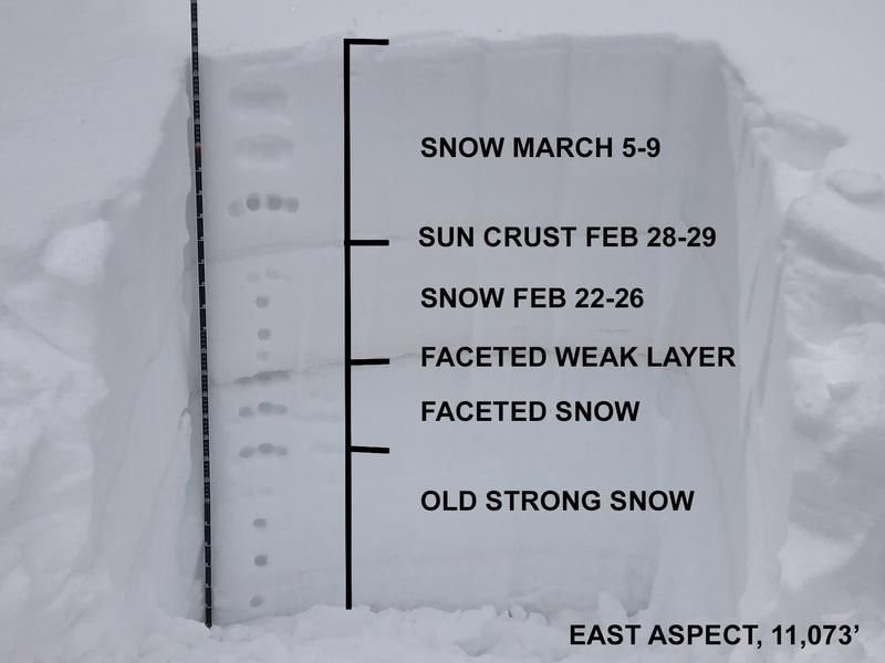
Yesterday was super warm with highs in the upper 30's and lots of sunshine. The snow pack has certainly taken a hit from this warm weather. You'll find Solar aspects crusted over. With clouds and colder temperatures today I'm expecting these slopes to stay frozen. The snow even started to get heavy on North aspects yesterday. Our snow pack continues to adjust to the storm that dropped two inches of water just over a week ago. A buried persistent weak layer of faceted snow that formed during the Jan-Feb high pressure is still capable of producing avalanches over two feet deep. Eric Trenbeath shot this video on Sunday 3/13. He discusses the snow pack and his thoughts on moving to Moderate danger a week after the storm.
Snow and Weather Links
Gold Basin SNOTEL site (10,000')
Storm Totals in Gold Basin
Wind Station on Pre Laurel Peak (11,700')
Recent Avalanches
It was an active weekend throughout the state for human triggered avalanches with almost all of the other zones reporting accidents and near misses. A lot can be learned from these reports, and it's certainly worth your time to read through them.
Ad
Avalanche Problem #1
Persistent Weak Layer
Type
Location
Likelihood
Size
Description
A persistent weak layer of loose, sugary faceted snow exists on W-N-E aspects beneath a slab that is 2' -3' thick. This problem is most pronounced on slopes facing NW-N-NE-E near treeline and below and the weak layer is easy to locate with your shovel. In my travels the past couple days I have found shallow weak snow at the lowest elevation bands. I am still getting failures in my snow pits on shady aspects below treeline. Gain a little elevation and the pack gets deeper and gains some strength. Stability tests show the buried weak layer is getting harder to trigger, but if triggered can propagate and release a slab avalanche over two feet deep. Do I think there are places out there you can trigger this layer? YES. Will you see me skiing avalanche terrain on the North half of the compass? No. Above treeline the weak layer distribution is much more variable and it is hard to track. Attempting to outsmart this avalanche problem in the alpine is a dangerous proposition. Likely trigger points include areas of shallow snow, slope margins, rocky outcroppings, and steep convex roll overs. We are just over a week out from the storm and here's a few key things to keep in mind:
  • Signs of instability will no longer be obvious
  • You most likely will not experience collapsing or cracking at this point
  • Ski tracks are not an indication of stability. Avalanches failing on a buried persistent weak layer can take out multiple sets of tracks.
This graphic shows the correlation between avalanche accidents and the danger rating. Regardless of whether it is a rising or falling danger, most accidents occur during the transition between Considerable and Moderate danger.
Avalanches failing on a buried persistent weak layer make up 51% of avalanche fatalities since 1940.
Additional Information
Eric's snow pit from Sunday 3/13 shows the weak layer of concern.
General Announcements
Who's up for some free avalanche training? Get a refresher, become better prepared for an upcoming avalanche class, or just boost your skills. Go to https://learn.kbyg.org/ and scroll down to Step 2 for a series of interactive online avalanche courses produced by the UAC.
This forecast is from the U.S.D.A. Forest Service, which is solely responsible for its content. This forecast describes general avalanche conditions and local variations always occur.