Forecast for the Moab Area Mountains

Eric Trenbeath
Issued by Eric Trenbeath on
Saturday morning, March 14, 2026

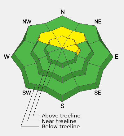
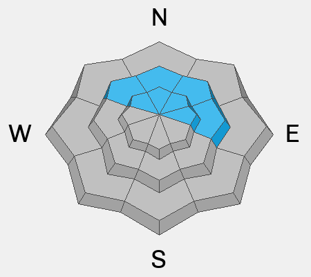
A MODERATE avalanche danger remains on steep slopes near and above treeline that face NW-N-E. Human-triggered, hard slab avalanches 2–4 feet deep, failing on a buried persistent weak layer, remain POSSIBLE in these areas. If triggered, these avalanches could step down and involve the entire season’s snowpack.

The likelihood for triggering this type of avalanche continues to decrease but the consequences remain the same. Likely trigger points include shallow rocky areas, thin spots along slope margins or convexities, or in areas of very steep, rocky, radical terrain.

Low
Moderate
Considerable
High
Extreme
Learn how to read the forecast here
Special Announcements

Geyser Pass Road Conditions: The road is melted down to dirt, expect wet and muddy conditions as the day heats up.

Grooming: No grooming is scheduled. Cover is thin, and conditions are rough.

Mountain Film on Tour returns to Star Hall in Moab on Saturday, March 14. Tickets are available online and all proceeds benefit UAC Moab. We look forward to seeing you all there!

Spring Fundraiser: Each spring, we ask for your continued financial support to fund our forecasting and education programs. Our Spring Campaign and Spring Auction are now live and we hope you will consider supporting our mission.

Link: https://utahavalanchecenter.org/civicrm/contribute/transact?reset=1&id=4

Weather and Snow

24 Hour Snow: 0" 72 Hour Snow: 0" Season Total Snow: 75" Depth at Gold Basin: 31"

Winds on Pre-Laurel Peak: WSW 15-20 Temp: 35°F

Weather

Under high clouds, temperatures are already above freezing at 10,000 feet. Overnight lows did dip below 30°F for a few hours however, and the snow surface should be crusted over and supportable this morning. Look for partly sunny and breezy conditions today with winds blowing 15-25 mph from the southwest. 10,000 ft temperatures will be near 50°F. A passing storm to the north and a strong cold front tonight will cause temperatures to crash into the teens, and Sunday looks cold and windy but mostly sunny. A warming trend begins on Monday before turning into a bonafide heatwave by Wednesday.

General Conditions

Mixed bag, spring like conditions are in effect and snow cover is dwindling, especially on south aspects (see my observation from yesterday). Corn snow on southerly aspects that hold snow has been the best game in town this week. It will likely be a bit more elusive this weekend without the right combination of cold, clear nights and warm sunny days, but I think you'll still be able to find some supportable skiing and riding out there this morning with winds keeping rapid warming at bay. Conditions will likely remain locked up on Sunday, with a return to corn snow on Monday and Tuesday.

The main threat from avalanches continues to be on northerly aspects near and above treeline, where hard slabs exist over layers of weak, dry, faceted snow.

See all Moab observations here.

Snowpack and Weather Data

Wind Station on Pre-Laurel Peak (11,400')
NWS forecast for the La Sal Mountains.
Recent Avalanches
No recent avalanches have been observed. The avalanche database has been updated to include all observed avalanches from the last cycle. These are all great examples of the type of avalanche that are possible to trigger.
Avalanche Problem #1
Persistent Weak Layer
Type
Location
Likelihood
Size
Description

Buried layers of weak, faceted snow continue to plague our snowpack near and above treeline on northerly facing slopes. Above treeline, thick, hard slabs 2-4 feet thick sit on top of these persistent weak layers. Although the likelihood for triggering a deep and dangerous avalanche has significantly decreased, all it takes is finding the right trigger point such as a shallow, rocky area or thin spot over a convexity. There are many slopes out there now where you can get away with it, but when it comes to life and death, I don't want to just get away with it, I want to know that it's good to go. For that reason, I'm continuing to avoid steep northerly aspects.

Additional Information
General Announcements
This forecast is from the U.S.D.A. Forest Service, which is solely responsible for its content. This forecast describes general avalanche conditions and local variations always occur.