Forecast for the Moab Area Mountains

Eric Trenbeath
Issued by Eric Trenbeath for
Monday, March 13, 2023
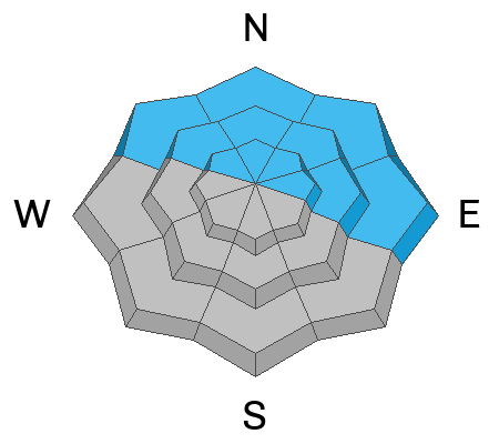
Areas of CONSIDERABLE danger remain on steep slopes above treeline that face NW-N-E where thick slabs of wind drifted snow are capable of producing avalanches 2'-4' deep.

The avalanche danger is MODERATE on all other aspects and elevations and human triggered avalanches are possible including loose, wet avalanches on sun exposed slopes as the day heats up.

Spring time in the mountains means that things can change quickly and there can be an assortment of avalanche problems within an hour or an aspect of one another. It is a good time to year to be willing to adapt and change your plan if the weather or snow conditions change.
Low
Moderate
Considerable
High
Extreme
Learn how to read the forecast here
Special Announcements
The Banff Centre Mountain Film Festival World Tour is coming to Moab March 17-18. For tickets and information go here.
Geyser Pass Road: Grand County will be plowing today and the gate will be closed while work is in progress.
Grooming: All trails are covered in fresh snow.
Weather and Snow
6:00 a.m. Snow and Weather Data
24 Hour Snow 4" 72 Hour Snow 18" Season Total Snow 247" Base Depth at Gold Basin 87"
Winds on Pre Laurel Peak W 5 Temp 13

Weather
A brief transient ridge today will bring quiet weather and partly sunny skies with a slight chance for snow showers developing late this afternoon. West winds will remain light, and high temps will be around 30F. Tuesday will bring increasing clouds and wind before the next Atmospheric River event impacts the area on Wednesday.

General Conditions
I don't have any reports from the backcountry so I'm keeping the danger elevated on northerly aspects above treeline until we have a better idea. Thick slabs of wind drifted snow have formed in these areas and they still seem like good places to avoid. Up to 14" of dense, heavy snow plastered the mountains on Friday, with another 4" yesterday. The wet snow appears to have bonded well to the old snow surface, but with nearly 2" of water weight added in some areas, I'm not quite ready to trust it just yet. The greatest danger exists on steep northerly aspects where deep drifts have formed, but it may still be possible to trigger an avalanche in the most recent snow on all aspects. If you observe signs of instability such as cracking or collapsing move to terrain less step than 30 degrees, and avoid steep, wind drifted slopes. And finally, with the sun coming out today, be alert to signs of wet instability such as rollerballs and pinwheels and stay off of steep slopes where these signs are present.
For the most recent observations go here. If you are getting out in the backcountry, let us know what you find.

Snowpack and Weather Data
Gold Basin Storm Stake (10,000')
Gold Basin SNOTEL site (10,000')
SNOTEL site near Geyser Pass Winter Trailhead (9600')
Wind Station on Pre-Laurel Peak (11,400')
NWS forecast for the La Sal Mountains.
Recent Avalanches
Visibility was poor yesterday and no new avalanches were reported. See the La Sal avalanche database here.
Ad
Avalanche Problem #1
Wind Drifted Snow
Type
Location
Likelihood
Size
Description
The greatest danger exists on steep, wind drifted slopes near and above treeline that face the north side of the compass. Slabs of wind drifted snow that formed during the height of the storm on Friday are gaining strength and may not display outward signs of instability such as cracking. This means you may get lured further down slope before they release. In some areas, wind drifted snow has built thick slabs over buried weak layers and avalanches 2'-4' deep are possible.
Avalanche Problem #2
Persistent Weak Layer
Type
Location
Likelihood
Size
Description
Weak layers of faceted snow are continually being observed in the snowpack though their distribution remains spotty. The most prevalent layer formed on northerly aspects during the high pressure of early February, and was subsequently buried on Valentines Day. This layer has yet to produce significant avalanche activity although slides that occurred on February 23 may be attributed to it. With the recent snow load adding more stress, it may be possible to trigger an avalanche 2'-4' deep down to this weak layer. Hopefully we'll get a better look around todaty to see how things have been affected.
Avalanche Problem #3
Normal Caution
Type
Location
Likelihood
Size
Description
Conditions are not green light on other aspects yet and there could be a variety of problems out there including lingering instabilities in the most recent snow. Faceted weak layers have also been turning up on other aspects (see this observation from Travis Nauman), and though avalanches breaking down to weak layers on southerly aspects are rare, they aren't unheard of, particulalrly on slopes facing SE. As the day heats up the recent snow will become more vulnerable and we could see loose wet avalanches or even slab releases in the most recent snow.
Spring time in the mountains means that things can change quickly and there can be an assortment of avalanche problems within an hour or an aspect of one another. It is a good time to year to be willing to adapt and change your plan if the weather or snow conditions change.
Additional Information
General Announcements
This forecast is from the U.S.D.A. Forest Service, which is solely responsible for its content. This forecast describes general avalanche conditions and local variations always occur. This forecast will be updated by 7:30 tomorrow morning.