Forecast for the Moab Area Mountains

Eric Trenbeath
Issued by Eric Trenbeath for
Sunday, March 12, 2023
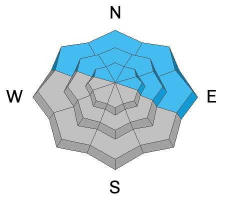
The avalanche danger is CONSIDERABLE on steep slopes near and above treeline that face NW-N-E and human triggered avalanches involving recent and wind drifted snow are likely.

The avalanche danger is MODERATE on all other aspects and elevations and human triggered avalanches are possible.

The mountains have received a significant load of wet, heavy snow. Avalanches stepping down to buried weak layers are possible. Give things time to adjust before venturing into steep terrain.
Low
Moderate
Considerable
High
Extreme
Learn how to read the forecast here
Special Announcements
The UAC is currently working with the operation involved in Thursday's fatal avalanche in the Uintas to prepare a report. Please be patient as we sort out the details of this complicated incident. A preliminary report is available HERE.
The Banff Centre Mountain Film Festival World Tour is coming to Moab March 17-18. For tickets and information go here.
Geyser Pass Road: Drifted snow has blocked access to the upper lot.
Grooming: All trails are covered in fresh snow.
Weather and Snow
6:00 a.m. Snow and Weather Data
24 Hour Snow 2" 72 Hour Snow 14" Season Total Snow 243" Base Depth at Gold Basin 87"
Winds on Pre Laurel Peak WSW 5-9 Temp 19

Weather
Pacific moisture on a westerly flow will keep clouds over the area with chance for light convective showers this afternoon. Westerly winds will be mostly light with high temps climbing into the low 30's. A brief transient ridge on Monday will bring quiet weather and partly sunny skies that linger into Tuesday before the next Atmospheric River event impacts the area on Wednesday.

General Conditions
6"-14" of dense, heavy snow plastered the mountains on Friday, which is just what we needed to smooth over the wind blasted surfaces underneath. The wet snow appears to have bonded well to the old snow surface, but with nearly 2" of water weight added in some areas, I'm not quite ready to trust it just yet. The greatest danger exists on steep northerly aspects where deep drifts have formed, but it may still be possible to trigger an avalanche in the most recent snow on all aspects. If you observe signs of instability such as cracking or collapsing move to terrain less step than 30 degrees, and avoid steep, wind drifted slopes. And finally, if the sun pokes out at all today, be alert to signs of wet instability such as rollerballs and pinwheels and stay off of steep slopes where these signs are present.
Travis Nauman and company were over near Gold Knob yesterday where they experienced several collapses and unstable test results on a SW aspect. See their full report here.
For the most recent observations go here. If you are getting out in the backcountry, let us know what you find.

Snowpack and Weather Data
Gold Basin Storm Stake (10,000')
Gold Basin SNOTEL site (10,000')
SNOTEL site near Geyser Pass Winter Trailhead (9600')
Wind Station on Pre-Laurel Peak (11,400')
NWS forecast for the La Sal Mountains.
Recent Avalanches
Visibility was poor yesterday and no new avalanches were reported. See the La Sal avalanche database here.
Ad
Avalanche Problem #1
New Snow
Type
Location
Likelihood
Size
Description
Human triggered avalanches within the most recent snow remain possible to likely. The danger is greatest on steep, northerly aspects where thick slabs of wind drifted snow have formed. On most other aspects the recent snow has bonded well to the old snow surface but continue to observe how the new snow is behaving. Be alert to signs of instability such as collapsing, or cracking in the snow surface and look for blocks of snow between your skis that indicate a slab. And finally, if the sun pokes out, the recent snow is at it's most vulnerable state for wet avalanches. Signs of instability include rollerballs or pinwheels, and sloppy wet snow.
Avalanche Problem #2
Persistent Weak Layer
Type
Location
Likelihood
Size
Description
Weak layers of faceted snow are continually being observed in the snowpack though their distribution remains spotty. The most prevalent layer formed on northerly aspects during the high pressure of early February, and was subsequently buried on Valentines Day. This layer has yet to produce significant avalanche activity although slides that occurred on February 23 may be attributed to it. With the recent snow load adding more stress, it may be possible to trigger an avalanche 2'-4' deep down to this weak layer.
Faceted snow around sun crusts can also be found on solar aspects (see observation from Travis Nauman). In most cases, these aren't associated with much avalanche activity though outlying instances occur. The bottom line is that with the recent heavy snow load, I'd give things a little more time to adjust before venturing into terrain steeper than 30 degrees.
Additional Information
General Announcements
This forecast is from the U.S.D.A. Forest Service, which is solely responsible for its content. This forecast describes general avalanche conditions and local variations always occur. This forecast will be updated by 7:30 tomorrow morning.