Forecast for the Moab Area Mountains

Eric Trenbeath
Issued by Eric Trenbeath for
Saturday, March 11, 2023
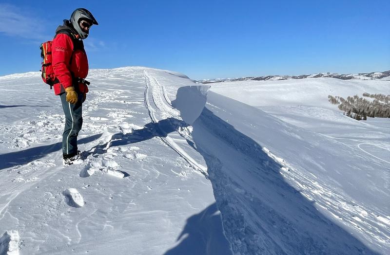
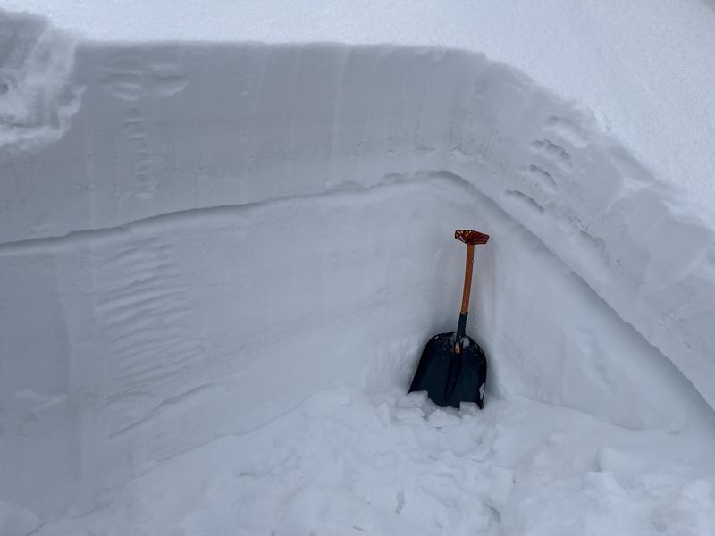
DENSE, HEAVY SNOW AND STRONG WINDS HAVE CREATED DANGEROUS AVALANCHE CONDITIONS!
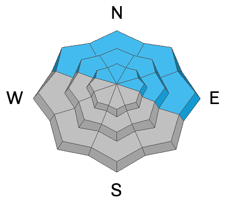
Areas of HIGH danger exist on steep, northerly facing slopes above treeline where human triggered avalanches are VERY LIKELY.

The danger is CONSIDERABLE on all other aspects and elevations where human triggered avalanches are LIKELY.

Backcountry travelers need to have excellent route finding skills and know how to recognize and avoid avalanche terrain. This means staying off of and out from under slopes steeper than 30 degrees.
Low
Moderate
Considerable
High
Extreme
Learn how to read the forecast here
Special Announcements
The UAC is sad to report that two skiers were caught and buried in a large avalanche in Upper Weber Canyon in the Uintas yesterday. One skier was successfully rescued and survived. Sadly, the other skier was buried deeper and did not survive. A preliminary report is available HERE.
The Banff Centre Mountain Film Festival World Tour is coming to Moab March 17-18. For tickets and information go here.
Geyser Pass Road: Expect to find accumulating and drifted snow on the road today. 4x4 required.
Grooming: All trails are covered in fresh snow.
Weather and Snow
6:00 a.m. Snow and Weather Data
24 Hour Snow 12" 72 Hour Snow 12" Season Total Snow 241" Base Depth at Gold Basin 87"
Winds on Pre Laurel Peak NA Temp 30

Weather
A winter storm warning remains in effect for the La Sal Mountains as a cold front moves over central and southern Utah. Look for continued snowfall today with 4"-8" possible. Ridge top westerly winds will blow in the 15-25 mph range with gusts in the 30's. Snow showers linger through tonight and into Sunday. Unsettled weather continues with yet another Atmospheric River event lining up for Wed.

General Conditions
The Gold Basin storm stake is reporting 12" of new snow while the nearby SNOTEL site is reporting half that with 1.6" Snow Water Equivalent (SWE). 1.2" SWE is being reported near the Geyser Pass Trailhead with overnight low temps staying above freezing. Regardless of actual snow amounts, this is a significant amount of water weight with the rain/snow line appearing to hover at or just below the trailhead. SW winds yesterday blew in the 25-35 mph range with gusts as high as 45 mph. This all adds up to dangerous avalanche conditions, and with continued snow and wind in the forecast expect conditions to remain dangerous.
For the most recent observations go here. If you are getting out in the backcountry, let us know what you find.

Snowpack and Weather Data
Gold Basin Storm Stake (10,000')
Gold Basin SNOTEL site (10,000')
SNOTEL site near Geyser Pass Winter Trailhead (9600')
Wind Station on Pre-Laurel Peak (11,400')
NWS forecast for the La Sal Mountains.
Recent Avalanches
I traveled to the Manti-Skyline on Thursday with Brett Kobernik, and UAC director Mark Staples, where we came up on a recent cornice release that turned out to be a very close call. A snowmobiler was riding too close to a cornice that broke off and took the rider down with it. He deployed his airbag and ended up partially buried but without serious injuries. MORE DETAILS HERE
See the La Sal avalanche database here.
Ad
Avalanche Problem #1
New Snow
Type
Location
Likelihood
Size
Description
Recent dense, heavy, wind drifted snow has created dangerous avalanche conditions and human triggered avalanches are likely on all aspects and elevations. Sensitivity within the most recent storm snow may vary depending on the surface it is trying to bond with, but expect to find soft cohesive slabs within the dense new snow that could break wider than you expect. In the wind zone, slabs of drifted snow up to 2' deep or more may be found and they will pack a punch. At the end of thre day, it goes without saying that steep, wind drifted slopes should be avoided as should all avalanche terrain.
Avalanche Problem #2
Persistent Weak Layer
Type
Location
Likelihood
Size
Description
On some northerly aspects, avalanches triggered in the new snow may step down to buried weak layers causing a deeper and more dangerous avalanche. The location of these weak layers is spotty, but in any case, travel advice remains the same, as all avalanche terrain should be avoided today.
Photo illustrates a weak layer of faceted snow under a slab that we found over in the Corkscrew Glades on Saturday (10,100' NW aspect). An extended column test produced results of ECTP 21. On Monday we also located this weak layer over near Miner's Basin. It was easily discernible by poking your pole down through the snow. Though not widespread, it's something you want to be continually looking for.
Additional Information
General Announcements
This forecast is from the U.S.D.A. Forest Service, which is solely responsible for its content. This forecast describes general avalanche conditions and local variations always occur. This forecast will be updated by 7:30 tomorrow morning.