Forecast for the Moab Area Mountains

Eric Trenbeath
Issued by Eric Trenbeath for
Friday, March 10, 2023
Heads up, an incoming storm will cause the avalanche danger to rise over the next 24 hours! Be alert to changing conditions!
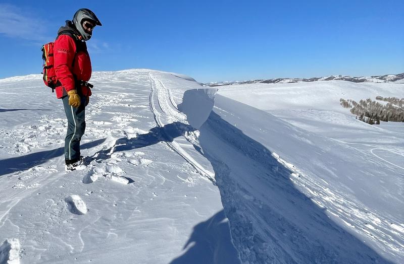
The avalanche danger is MODERATE today but is expected to rise over the next 24 hours, possibly as early as this afternoon or evening. Be on the lookout for fresh deposits of wind drifted snow accumulating on the leeward sides of ridge crests and terrain features, primarily on slopes near treeline and above that face W-N-SE. Suspect slopes steeper than 30 degrees that have more than about 8" of wind drifted snow with the greatest danger developing on steep, northerly aspects.

Though the odds are decreasing, a MODERATE danger still exists for triggering an old, hard wind slab on slopes facing W-N-SE near treeline and above.

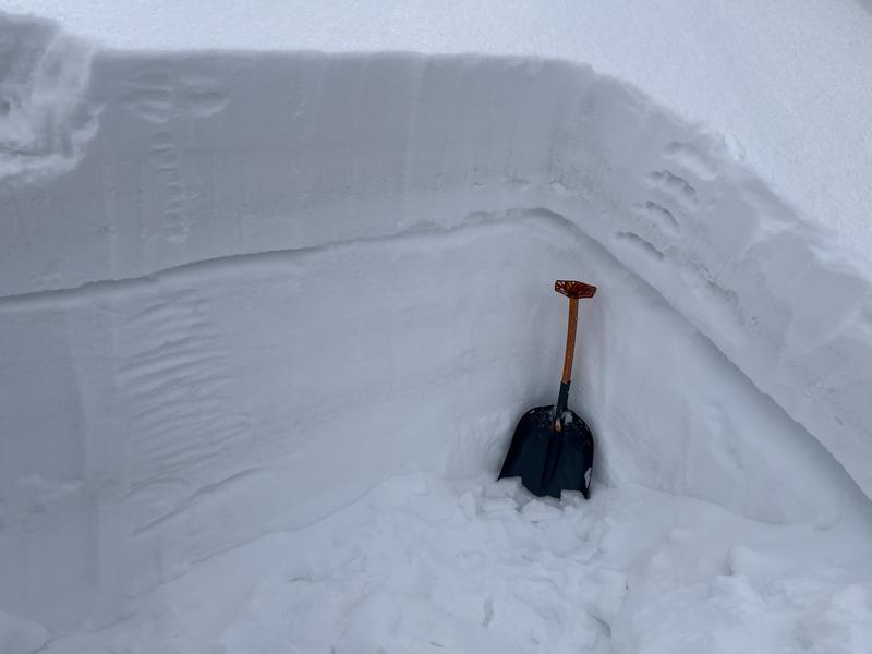
And finally, some northerly facing slopes harbor weak layers of faceted snow and human triggered avalanches 1'-3' deep are possible.

Backcountry travelers should avoid wind drifted slopes and be able to determine the absence of a weak layer before committing to terrain steeper than 30 degrees.
Low
Moderate
Considerable
High
Extreme
Learn how to read the forecast here
Special Announcements
The UAC is sad to report that two skiers were caught and buried in a large avalanche in Upper Weber Canyon in the Uintas yesterday. One skier was successfully rescued and survived. Sadly, the other skier was buried deeper and did not survive. A preliminary report is available HERE.
The Banff Centre Mountain Film Festival World Tour is coming to Moab March 17-18. For tickets and information go here.
Geyser Pass Road: Expect accumulating and fresh drifting of snow on the road today.
Grooming: Matt groomed all trails on Tuesday.
Weather and Snow
6:00 a.m. Snow and Weather Data
24 Hour Snow 0" 72 Hour Snow 0" Season Total Snow 229" Base Depth at Gold Basin 77"
Winds on Pre Laurel Peak SSE 30-40 G50 Temp 30

Weather
Southwest flow over the region is pulling in moisture from yet another Atmospheric River. 10,000' temps are hovering just below freezing, and our old nemesis "Uncle Gusty" is at it again with southerly ridge top winds blowing 30-40 mph. Today will be moist, warm, and very windy with snowfall likely starting around mid-day. The track looks slightly more northerly than previous events so my confidence is low in what we might see for snow. 3"-5" seem likely by late this afternoon/evening with the heaviest snow kicking in tonight. Another 4"-8" are possible overnight with snowfall continuing into Saturday. By Saturday, winds decrease and swing more westerly and we should see a tapering in snowfall though cloudy skies and a chance for snow lingers into Sunday.

General Conditions
It's going to be rugged out there today with an incoming storm, strong winds, and a widely variable snow surface. It seems like waiting until tomorrow for conditions to improve might be the best call. As snow starts to fly today, be on the lookout for fresh deposits of wind drifted snow, especially if snow starts to fall early or we get more than expected. You still may be able to trigger an old, hard wind slab though the odds are decreasing. On some northerly facing slopes, slabs 1'-3' thick are sitting on top of buried weak layers. You are most likely to find this problem right around treeline or just below, and the only way to know for sure is to pull out your shovel and dig.
For the most recent observations go here. If you are getting out in the backcountry, let us know what you find.

Snowpack and Weather Data
Gold Basin Storm Stake (10,000')
Gold Basin SNOTEL site (10,000')
SNOTEL site near Geyser Pass Winter Trailhead (9600')
Wind Station on Pre-Laurel Peak (11,400')
NWS forecast for the La Sal Mountains.
Recent Avalanches
I traveled to the Manti-Skyline yesterday with Brett Kobernik, and UAC director Mark Staples, where we came up on a recent cornice release that turned out to be a very close call. A snowmobiler was riding too close to a cornice that broke off and took the rider down with it. He deployed his airbag and ended up partially buried but without serious injuries. MORE DETAILS HERE
See the La Sal avalanche database here.
Ad
Avalanche Problem #1
Wind Drifted Snow
Type
Location
Likelihood
Size
Description
As new snow piles up, be on the lookout for fresh slabs of wind drifted snow. Slabs will become deeper, more sensitive, and more widespread as the storm progresses. Look for them on the leeward sides of ridge crests and terrain features such as gully walls and sub ridges. I don't anticipate them to become too dangerous until tomorrow, but pay attention as we could get more snow earlier than expected. Avoid steep slopes that have more than about 8" of drifted snow, and look for signs of instability such as cracking in the snow surface.
And though the odds are decreasing, it may still be possible to trigger an old, hard wind slab. Suspect steep slopes that have a smooth rounded appearance or that sound hollow underneath.
Avalanche Problem #2
Persistent Weak Layer
Type
Location
Likelihood
Size
Description
In our recent travels we have been finding reactive weak layers in the upper meter of the snowpack. The distribution of these layers is spotty - they exist in some places and not in others. Regardless, these layers are capable of producing avalanches. The strategy right now for northerly aspects is to dig occasional pits and look for facets as you ascend. If this is beyond your skill set, choose a different aspect or keep your slope angles under 30 degrees. For more information about these faceted weak layers read Dave's observation from Tuesday.
Photo illustrates a weak layer of faceted snow under a slab that we found over in the Corkscrew Glades on Saturday (10,100' NW aspect). An extended column test produced results of ECTP 21. On Monday we also located this weak layer over near Miner's Basin. It was easily discernible by poking your pole down through the snow. Though not widespread, it's something you want to be continually looking for.
Additional Information
General Announcements
This forecast is from the U.S.D.A. Forest Service, which is solely responsible for its content. This forecast describes general avalanche conditions and local variations always occur. This forecast will be updated by 7:30 tomorrow morning.