Join us at our 2nd Annual Blizzard Ball

Forecast for the Moab Area Mountains

Eric Trenbeath
Issued by Eric Trenbeath on
Saturday morning, March 13, 2021
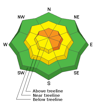
Heads up, increasing avalanche danger over the next 24 hours! The avalanche danger is CONSIDERABLE on steep, wind drifted slopes above treeline that face NW-N-E-SE and human-triggered avalanches are likely in these areas. As new snow accumulates and winds shift direction the danger will become more widespread. Be alert to loading patterns and avoid steep slopes with recent deposits of wind drifted snow. In these same areas, there also remains a MODERATE danger for triggering a deeper avalanche on a buried persistent weak layer of sugary, faceted snow. Likely trigger points include thin snowpack areas along slope margins or around rock outcroppings. Wind drifted snow will add additional stress to these areas. And finally, as snow accumulates the potential for new snow avalanches will increase on steep slopes on all aspects. Suspect steep slopes that have about 6" or more of new snow.
Low
Moderate
Considerable
High
Extreme
Learn how to read the forecast here
Special Announcements
The Geyser Pass Road was plowed yesterday but more snow is on the way. 4x4 will be required as new snow piles up.
The Lower Utah Nordic Alliance (LUNA) packed in the fresh snow yesterday but more is on the way.
Weather and Snow
24 Hour Snow 3" 72 Hour Snow 10" Base Depth in Gold Basin 57" Wind SE 15-20 G30 Temp 17F
The much advertised low-pressure system is currently moving through Southern Utah with a strong southerly flow advecting a steady stream of moisture over our region. Today should see periods of heavy snowfall before the flow shifts to a less favorable westerly this afternoon. 4"-7" are possible today. Tonight should see another uptick in precipitation as wraparound moisture shifts the flow to the northwest and we could see another 4"-7" by Sunday morning. Most of the action will be over on Sunday with lingering showers and blustery NW winds. A short-lived, low amplitude ridge builds on Monday before the next low-pressure system moves through the region on Tuesday, followed by ridge building, and drier and warmer conditions through the end of the week.
Wind, temperature, humidity on Pre Laurel Peak (11,700')
Snotel site near Geyser Pass Trailhead (9600')
Storm totals at the Gold Basin study plot (10,000')
Snowpack Discussion
3" of new snow overnight brings totals since Tuesday up to 15". In our travels yesterday, we observed strong southerly winds blowing and drifting the new snow onto northerly aspects while alternately scouring southerlies. Fresh drifts up to 18" were observed. As more snow piles up today, we could see some natural soft slab releases or fast running, loose snow sluffs off of some of the larger and steeper terrain. Today is a good day to stay out from underneath the NE face of Tukno for example. Persistent weak layers of faceted snow still exist in the lower portion of the snowpack. Though the likelihood of triggering an avalanche down there has decreased significantly over time, fresh deposits of wind drifted snow may reignite the potential, especially in thinner snowpack areas around rock bands or along slope margins.
Ad
Avalanche Problem #1
Wind Drifted Snow
Type
Location
Likelihood
Size
Description
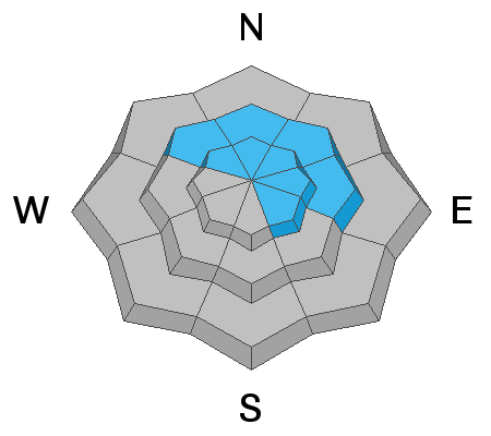
Blowing and drifting snow has created unstable wind slabs up to 18" deep on leeward slopes near and above treeline. As new snow accumulates and the wind direction shifts, expect slabs to become mote widespread. Look for them on the leeward sides of ridge crests and terrain features and simply pay attention to where snow is being transported. Wind drifts are recognizable by their smooth, rounded appearance and cracking is a sign if instability. On steep, northerly aspects, wind drifted snow has added additional stress to buried persistent weak layers. You could trigger a wind slab that then steps-down into deeper instabilities below. Avoid steep, wind drifted slopes today, and especially those with a northerly aspect.
Avalanche Problem #2
Persistent Weak Layer
Type
Location
Likelihood
Size
Description
Poor snowpack structure still exists with consolidated slabs resting on buried persistent weak layers of loose, sugary, faceted snow on NW-NE-SE aspects near and above treeline. Though the likelihood of triggering an avalanche down there has decreased significantly over time, fresh deposits of wind drifted snow may reignite the potential, especially in thinner snowpack areas around rock bands, along slope margins, or in areas of steep, rocky, radical terrain. It's time to push the reset button and see how the snowpack adjusts to the new snowload before venturing on to steep, northerly facing slopes.
Avalanche Problem #3
New Snow
Type
Location
Likelihood
Size
Description
We may start to see some loose snow sluffs on steep slopes on all aspects as snow accumulates today. Suspect avalanches within the new snow on slopes steeper than 35 degrees that have more than about 6" of new snow. These should be mostly small and manageable but we could see some natural releases off of higher and bigger terrain where a small sluff can gather a lot of snow. This is a good day to stay out from under the larger faces such as the NE face of Tukno where a gathering sluff or soft slab avalanche will pack quite a punch by the time it makes it to the bottom.
Additional Information
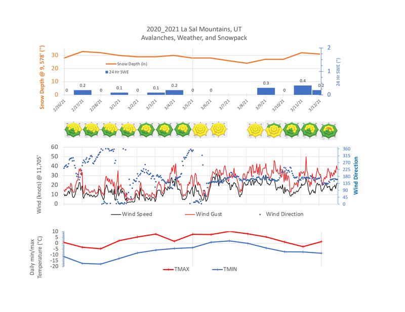
Here is a weather summary of the last two weeks compiled by Chris Benson.
General Announcements
This forecast is from the U.S. Forest Service, which is solely responsible for its content. This forecast describes general avalanche conditions and local variations always occur.