Join us at our 2nd Annual Blizzard Ball

Forecast for the Moab Area Mountains

Eric Trenbeath
Issued by Eric Trenbeath on
Friday morning, March 12, 2021
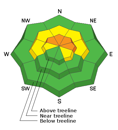
Areas of CONSIDERABLE danger exist on steep, wind drifted, northwest through east-facing slopes above treeline. As winds increase today, we could see some natural soft slab releases or fast running, loose snow sluffs off of some of the larger and steeper terrain so give it a wide berth. There also remains a MODERATE danger for triggering a deep and dangerous avalanche on a buried persistent weak layer of sugary, faceted snow on slopes near and above treeline that face northwest through southeast. Likely trigger points include thin snowpack areas along slope margins or around rock outcroppings. Wind drifted snow will add additional stress to these areas. Most south, west, and low elevation terrain offers generally LOW danger.
Low
Moderate
Considerable
High
Extreme
Learn how to read the forecast here
Special Announcements
The Geyser Pass Road will have a few inches of new snow over a mix of dirt and patches of ice and snow. All-wheel drive with good tires recommended.
The Lower Utah Nordic Alliance (LUNA) will be packing in the new snow today.
Weather and Snow
24 Hour Snow 7" 72 Hour Snow 12" Base Depth in Gold Basin 56" Wind SE 15-20 G32 Temp 18F
Well-positioned bands of moisture yesterday brought 5"-7" of low-density snow to the mountains. Moderate southerly winds blew all day, increasing overnight into the 20-25 mph range with gusts into the 40's. Today look for cloudy skies and redeveloping snow showers midday as more moisture ahead of the closed Pacific low streams into the area. 1"-3" are possible. Southerly winds will blow in the 15-25 mph range with gusts as high as 40 along ridge tops. Light snow should continue overnight. The low will make its way through the 4 Corners region sometime on Saturday though timing and duration, along with snow amounts are still somewhat in question. It's now looking like only a few inches on Saturday with the best chance for snow coming Saturday night into Sunday. All said and done, it's still looking like another 6"-12" between now and Sunday.
Wind, temperature, humidity on Pre Laurel Peak (11,700')
Snotel site near Geyser Pass Trailhead (9600')
Storm totals at the Gold Basin study plot (10,000')
Snowpack Discussion
Up to a foot of snow since Tuesday has improved conditions though crusts and old tracks can still be felt underneath, particularly on sunnier aspects. The new, low-density snow will be easily transported by the wind and fresh, unstable drifts will be found on the leeward sides of ridge crests and terrain features, primarily in upper elevation, wind exposed terrain. As winds increase today, we could see some natural soft slab releases or fast running, loose snow sluffs off of some of the larger and steeper terrain. Today is a good day to stay out from underneath the NE face of Tukno for example. Persistent weak layers of faceted snow still exist in the lower portion of the snowpack but the likelihood of triggering an avalanche down there has decreased significantly. Thin snowpack areas around rock bands or along slope margins on steep slopes facing NW-N-E remain the areas of greatest concern and fresh deposits of wind drifted snow will add additional stress to these areas.
Ad
Avalanche Problem #1
Wind Drifted Snow
Type
Location
Likelihood
Size
Description
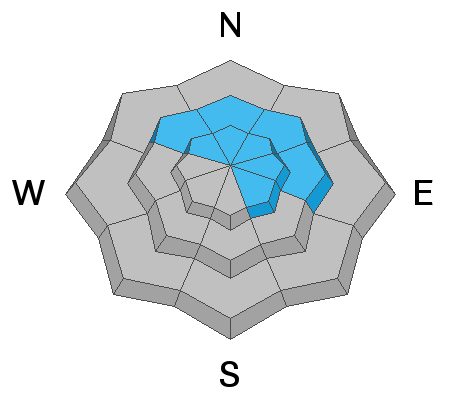
Moderate to strong southerly winds have been depositing the recent snow on to leeward, northerly facing slopes. Today, expect to find fresh, unstable drifts on the leeward sides of ridge crests and terrain features, primarily in upper elevation, wind exposed terrain. Wind drifts are recognizable by their smooth, rounded appearance and cracking is a sign if instability. On steep, northerly aspects, wind drifted snow has added additional stress to buried persistent weak layers. You could trigger a wind slab that then steps-down into deeper instabilities below. The bottom line is that steep, wind loaded, northerly-facing terrain is where you are most likely to trigger a deep and dangerous avalanche.
Avalanche Problem #2
Persistent Weak Layer
Type
Location
Likelihood
Size
Description
Poor snowpack structure still exists with consolidated slabs resting on buried persistent weak layers of loose, sugary, faceted snow on NW-NE-SE aspects near and above treeline. The most dangerous areas include places where wind-drifted snow has created slabs 1'-3' deep on top of these buried weak layers. These avalanches are becoming harder to trigger but once released, they will be large and destructive. Likely trigger points include shallower areas along slope margins, around sparse trees or rock outcroppings, or on repeat running slide paths.

General Announcements
This forecast is from the U.S. Forest Service, which is solely responsible for its content. This forecast describes general avalanche conditions and local variations always occur.