Join us at our 2nd Annual Blizzard Ball

Forecast for the Moab Area Mountains

Eric Trenbeath
Issued by Eric Trenbeath on
Thursday morning, March 11, 2021
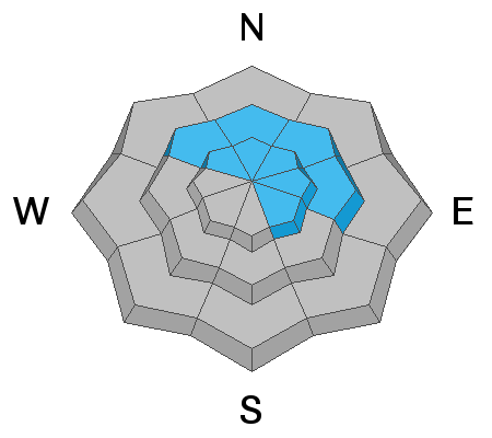
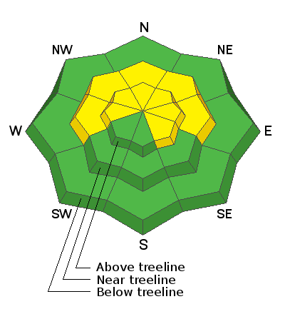
The avalanche danger is MODERATE but expect a rising danger over the next few days. Be alert to changing conditions and increasing signs of instability such as blowing and drifting snow and cracking in the snow surface. Strong southerly winds are creating fresh deposits of wind drifted snow on northerly aspects near and above treeline. As more snow accumulates, drifts will become more sensitive and more widespread. Look for them on the leeward sides of ridge crests and terrain features such as gully walls and sub ridges and avoid steep slopes with recent deposits of wind drifted snow. On steep slopes facing NW-N-E-SE it is still possible to trigger an avalanche on a buried persistent weak layer. Thin snowpack areas near rock outcroppings and along slope margins are likely trigger points. Avoid steep convexities and blind break overs.
Low
Moderate
Considerable
High
Extreme
Learn how to read the forecast here
Special Announcements
The Geyser Pass Road is a mix of dirt with patches of snow and ice.
The Lower Utah Nordic Alliance (LUNA) has not groomed since last Thursday.
Weather and Snow
24 Hour Snow 1" 72 Hour Snow 5" Base Depth in Gold Basin 49" Wind S 20-25 G57 Temp 15F
In spite of what appeared to be a period of intense precipitation last night, it looks like we only picked up maybe an inch of snow. For the next 24 hours, a closed low spinning off the coast of California will send bands of precipitation into our area creating mostly scattered showers. Today will be mostly cloudy and windy with moderate to strong southerly winds and perhaps a couple of inches of snow. By Friday night, the low will begin tracking through the 4 Corners region with our best shot at snow on Saturday. Most of the emphasis from this powerful system is on an upslope event for the mountains above Denver where several feet of snow are likely. I'm still uncertain what it will mean for us and think we could see anywhere from 6"-12".
Wind, temperature, humidity on Pre Laurel Peak (11,700')
Snotel site near Geyser Pass Trailhead (9600')
Storm totals at the Gold Basin study plot (10,000')
Snowpack Discussion
The snowpack is highly variable, with large differences across aspects and elevations. Overall, warm temperatures over the last several days and even some rain Tuesday evening followed by hard freezes the last two nights have strengthened the snowpack, but they've also left most surfaces crusted over. Strong southerly winds have added to the destruction. Recent snowfall has freshened things up a bit in sheltered areas but given the state of the snow surface overall, it's going to take more than a few inches to see a major improvement. Persistent weak layers of faceted snow still exist in the lower portion of the snowpack but the likelihood of triggering an avalanche down there has decreased significantly. Thin snowpack areas around rock bands or along slope margins on steep slopes facing NW-N-E remain the areas of greatest concern.
Ad
Avalanche Problem #1
Persistent Weak Layer
Type
Location
Likelihood
Size
Description
Poor snowpack structure exists with consolidated slabs resting on buried persistent weak layers of loose, sugary, faceted snow on NW-NE-SE aspects near and above treeline. The most dangerous areas include places where wind-drifted snow has created slabs 1'-3' deep on top of these buried weak layers. These avalanches are becoming harder to trigger but once released, they will be large and destructive. Likely trigger points include shallower areas along slope margins, around sparse trees or rock outcroppings, or on repeat running slide paths.
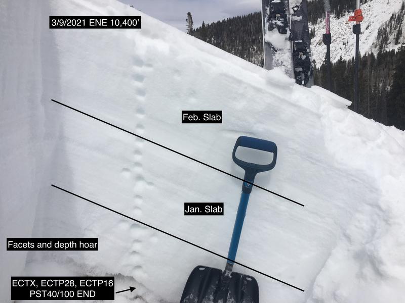
Stability tests performed by Chris Benson on Tuesday were inconsistent on this ENE aspect near treeline location, possibly due to some shallowly-buried rocks. Both failure and propagation became more pronounced near the buried rocks and could illustrate that while hard-to-trigger, dense slabs resting on loose facets are still capable of producing a large and destructive avalanche if you hit a weak spot where the slab thins.
Avalanche Problem #2
Wind Drifted Snow
Type
Location
Likelihood
Size
Description
Over the last two days, 20-50 mph southerly winds have been redistributing what little snow is available for transporting onto a variety of aspects on the northern half of the compass. With some fresh snow and more wind in the forecast today, look for fresh drifts on the leeward sides of ridge crests and terrain features like sub-ridges and gully walls. On steep, northerly aspects, wind drifted snow has added additional stress to buried persistent weak layers. You could trigger a wind slab that then steps-down into deeper instabilities below. The bottom line is that steep, wind loaded, northerly-facing terrain is where you are most likely to trigger a deep and dangerous avalanche.
General Announcements
This forecast is from the U.S. Forest Service, which is solely responsible for its content. This forecast describes general avalanche conditions and local variations always occur.