Fall Auction is now live! Check it out now

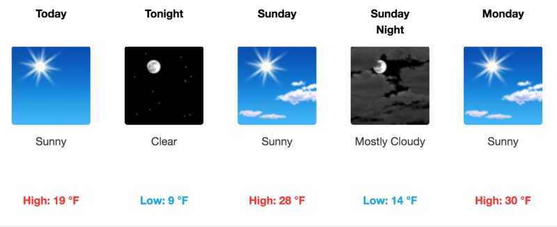
Forecast for the Moab Area Mountains

Eric Trenbeath
Issued by Eric Trenbeath on
Saturday morning, February 26, 2022
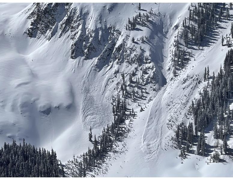
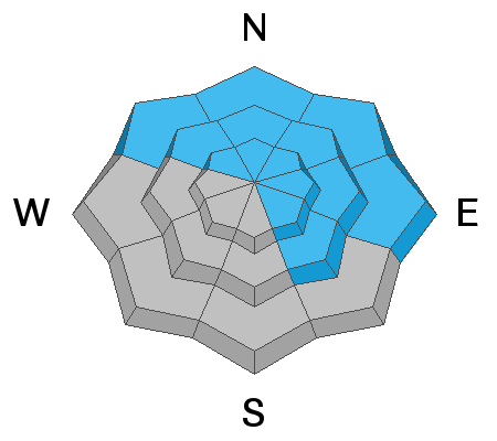
The avalanche danger remains CONSIDERABLE on steep, wind drifted slopes facing the north to southeast side of the compass and human triggered avalanches 2'-3' deep are likely in these areas. A MODERATE avalanche danger exists on all other steep slopes and human triggered avalanches remain possible. Continue to stay on your best behavior as you enjoy fresh powder and sunny skies this weekend by avoiding steep, northerly facing terrain.
Low
Moderate
Considerable
High
Extreme
Learn how to read the forecast here
Special Announcements
Road Conditions: The road is plowed snowpacked and the surface soft with shallow ruts near the trailhead. AWD and good tires are recommended.
Grooming: LUNA Matt groomed into Gold Basin on Friday. Follow LUNA on Instagram @luna_moab.
Weather and Snow
6:00 a.m. weather data:
24 Hour Snow 0" 72 Hour Snow 9" Base Depth at Gold Basin 56" Wind NW 5-15 Temp -6F
Temperatures are in negative territory this morning and though it's going to be a beautiful day you may not want to rush out the door until it warms up a bit! Today we'll see sunny skies, light NW winds and temps at 10,000' barely climbing out of the upper teens. A weak shortwave will bring cloudy skies to the area on Sunday night. Dry and slowly but steadily warming conditions are on tap through mid-week. A weak low pressure system moves on shore in the Pacific Northwest on Thursday bringing a slight chance for snow showers on Friday but don't hold your breath for this one.
NWS Weather Forecast for the La Sal Mountains
Gold Basin SNOTEL site (10,000')
Storm Totals in Gold Basin
Wind Station on Pre Laurel Peak (11,700')
Snowpack
The snow is beginning to settle after this week's storm cycle brought up to 30" of new snow to the mountains but it's still deep out there. In our travels on snow machines yesterday we found excellent powder and over the hood conditions. We also continued to observe signs of instability such as cracking in the snow surface and slab failures on steep road banks. Observers also reported collapsing and cracking. Check out these reports from Tim Mathews and Travis Nauman. Throughout much of the storm cycle SW winds blew and drifted snow onto leeward, northerly aspects. Drifts have formed over a variety of old snow surfaces including hard and crusted, to loose, weak and faceted. The weakest underlying snow can be found on sheltered, northerly facing slopes right around treeline and below. Above treeline the distribution of this weak layer is much more variable. As the recent snow continues to settle, and the danger becomes less obvious, the presence of buried weak, faceted snow will continue to be problematic.
Recent Avalanches
Tim Mathews sent in this photo of natural avalanche activity that occurred during the height of the storm on Wednesday. You can read his observation here.
Ad
Avalanche Problem #1
Persistent Weak Layer
Type
Location
Likelihood
Size
Description
Recent and wind drifted snow has begun to pile up on a variety of old snow surfaces and faceted, weak layer combinations. The weakest snow can be found on sheltered, northerly aspects near treeline and below where the degree of near surface faceting was greatest. Branching out from there, a variety of crust/facet combinations can be found. The uneven and variable type of weakness makes things tricky, but for now it should be assumed that human triggered avalanches failing on a buried weak layer remain likely on steep slopes facing NW-N-NE-E-SE.
General Announcements
Who's up for some free avalanche training? Get a refresher, become better prepared for an upcoming avalanche class, or just boost your skills. Go to https://learn.kbyg.org/ and scroll down to Step 2 for a series of interactive online avalanche courses produced by the UAC.
This forecast is from the U.S. Forest Service, which is solely responsible for its content. This forecast describes general avalanche conditions and local variations always occur.