Forecast for the Moab Area Mountains

Mark Staples
Issued by Mark Staples on
Sunday morning, February 27, 2022
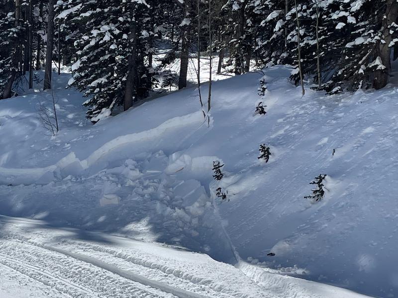
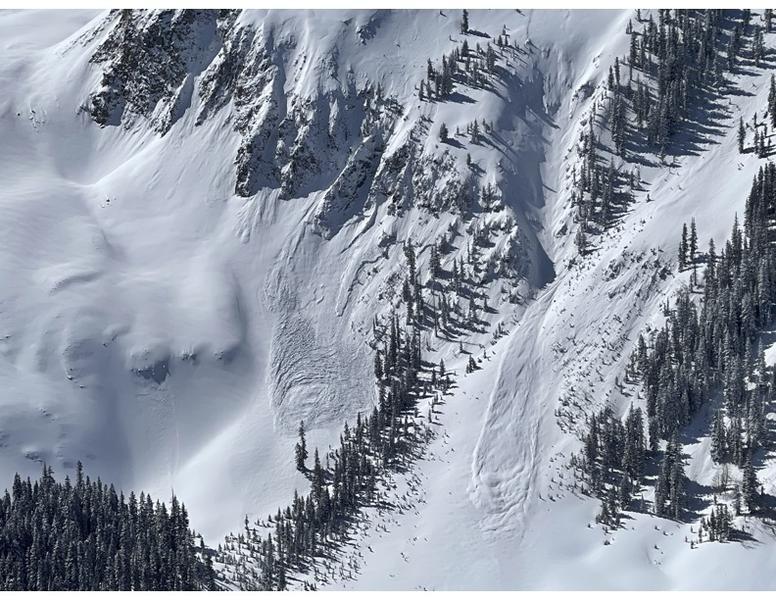
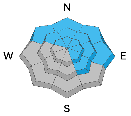
With a widespread weak layer under this week's new snow, conditions remain dangerous on northerly facing slopes as well as ones facing east and southeast. Avalanches up to 2-3 feet deep are likely in these areas and the avalanche danger is CONSIDERABLE. With so much new snow, human triggered avalanches remain possible on other aspects where the danger is MODERATE although the new snow is stabilizing quickly.
Don't assume that riding and skiing well below treeline is safer. In fact it is the opposite situation because the weak layer that will produce avalanches is much more widespread near and below treeline while it's existence above treeline is more pockety.
Low
Moderate
Considerable
High
Extreme
Learn how to read the forecast here
Special Announcements
Road Conditions: The road is plowed snowpacked and the surface soft with shallow ruts near the trailhead. AWD and good tires are recommended.
Grooming: LUNA Matt groomed into Gold Basin on Friday. Follow LUNA on Instagram @luna_moab.
Weather and Snow
6:00 a.m. weather data:
24 Hour Snow 0" 72 Hour Snow 0" Base Depth at Gold Basin 54" Wind N 10-20 Temp 7F
Clear skies overnight allowed temperatures to drop into the single digits and teens F which is quite a bit warmer than yesterday morning. Winds from the north should ease today, and they may blow from the south later today but will remain light. Stong sunshine will allow temperatures to quickly warm and will be near 30 degrees F today. This week will have very warm weather followed by an "active" weather pattern by the end of the week, but it doesn't look very promising for snowfall just yet.
NWS Weather Forecast for the La Sal Mountains
Gold Basin SNOTEL site (10,000')
Storm Totals in Gold Basin
Wind Station on Pre Laurel Peak (11,700')
Snowpack
Snow on slopes receiving direct sunshine yesterday became damp and should have an ice crust on top this morning. More northerly facing slopes still have great powder that has settled and gained density.
The main issue in the snowpack is a layer of weak, faceted snow that formed on the snow surface during the long period of dry weather. On shaded and wind-sheltered slopes, this layer is widespread and produced cracking and very small avalanches (photo below) on nearly every small road cut and road bank we touched yesterday while riding into Dark Canyon to the east of Gold Basin. Other folks observed collapsing and cracking this week. In fact, this layer caused us to turn around as we were riding along a summer road to Geyser Pass yesterday because we would have had to cross under a small steep slope that surely would have avalanched. This layer has a more pockety distribution above treeline where it existed in some places but not others prior to this week's snowfall.
Southwest winds drifted the new snow this week and formed many wind slabs above treeline. Many of these are glued into place; however, others may be resting on this faceted layer and remain unstable. The challenge is that it's nearly impossible to know the difference. It's basically a coin toss which ones could be triggered and which wind slabs remain unstable.
Many small slopes like this one either cracked or produced tiny avalanches yesterday.
Recent Avalanches
Tim Mathews sent in this photo of natural avalanche activity that occurred during the height of the storm on Wednesday. You can read his observation here.
Widespread cracking on any shaded slope yesterday while riding into Dark Canyon was a major red flag.
Ad
Avalanche Problem #1
Persistent Weak Layer
Type
Location
Likelihood
Size
Description
A persistent weak layer of faceted snow under the new snow from this week's snowfall (photo below) can fracture and produce soft slab avalanches today. This layer exists on northerly facing slopes as well as east and southeast where it may be capped by a thin ice crust. Below and near treeline, this layer is widespread. Above treeline it is easy to find but exists in an uneven and variable pattern, so we just have to assume it exists everywhere.
The million dollar question is - how long will this layer remain unstable? The only clear answer I have is that it takes time to heal, and I wouldn't trust it today. The simple presence of this layer is all I need to know in order to avoid avalanche terrain today.
General Announcements
Who's up for some free avalanche training? Get a refresher, become better prepared for an upcoming avalanche class, or just boost your skills. Go to https://learn.kbyg.org/ and scroll down to Step 2 for a series of interactive online avalanche courses produced by the UAC.
This forecast is from the U.S.D.A. Forest Service, which is solely responsible for its content. This forecast describes general avalanche conditions and local variations always occur.