Forecast for the Moab Area Mountains

Mark Staples
Issued by Mark Staples on
Monday morning, February 28, 2022
Warm sunny weather doesn't change the situation. Last week's new snow is resting on a widespread weak layer of facets, and it continues to give obvious signs of instability. For these reasons, the avalanche danger is CONSIDERABLE on northerly facing slopes as well as east and southeast facing ones where you are most likely to find this layer which is creating dangerous avalanche conditions.
Human triggered avalanches are possible on all other slopes and the danger is MODERATE.
Low
Moderate
Considerable
High
Extreme
Learn how to read the forecast here
Special Announcements
Road Conditions: The road is plowed. AWD and good tires are recommended.
Grooming: LUNA Matt groomed into Gold Basin on Friday. Follow LUNA on Instagram @luna_moab.
Weather and Snow
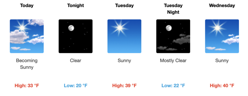
6:00 a.m. weather data:
24 Hour Snow 0" 72 Hour Snow 0" Base Depth at Gold Basin 52" Wind NW 10-15 Temp 18F
There are a few clouds overhead this morning that will clear out today. Yesterday winds blew all around the compass (N->NE->S->W) and are back to blowing from the NW. Following bitter cold temperatures last week, there has been a steady warming trend that will continue through Thursday of this week when some of the warmest air will be over the area. Today will have clear sunny skies and temperatures at 10,000 ft getting into the mid 30s F although it will likely feel warmer than that. Looking ahead, Friday will have a noticeable drop in temperatures with some clouds and the arrival of maybe a dusting of snow. More snow may fall over next weekend, but that's too far out to know for sure what will happen.
NWS Weather Forecast for the La Sal Mountains
Gold Basin SNOTEL site (10,000')
Storm Totals in Gold Basin
Wind Station on Pre Laurel Peak (11,700')
Snowpack
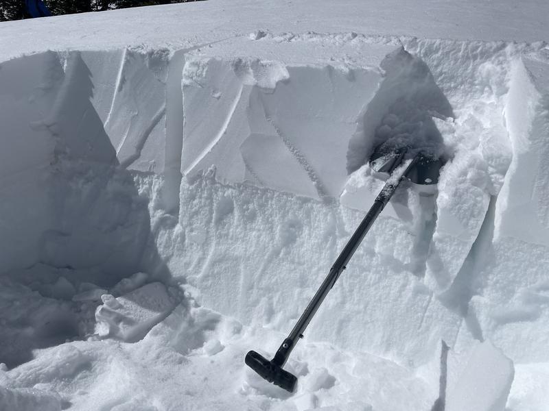
The snow on south and west-facing slopes became very wet yesterday. I suspect east-facing slopes became damp as well. There should be a decent ice crust this morning that will break down quickly. Last week's 30 inch storm has settled to about half that amount and remains dry on northerly facing slopes. The main issue is a layer of weak, faceted snow underneath the new snow from last week.
Photo shows the wet snow yesterday sticking to a ski with no skins on (Garcia).
Recent Avalanches
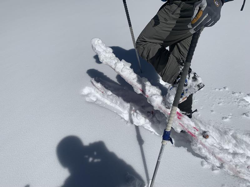
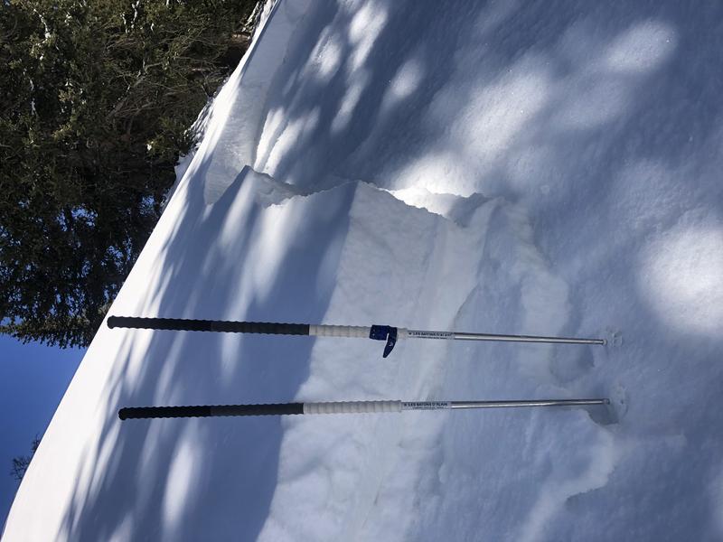
Most of the avalanche activity occurred last week during a period of very high precipitation and strong SW winds. Since then, the snowpack continues to talk to us by producing small avalanches on wind and sun sheltered slopes. Eric, Trent, and I triggered many road cuts near Dark Canyon on Saturday. Yesterday on a shaded west-facing slope at 10,600, Dave Garcia and his partner triggered this avalanche 2 ft deep and 25 ft wide. While it was on a west-facing slope, it is one that is shaded by trees and may act more like a north-facing slope.
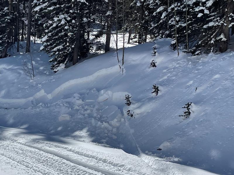
Photo of a road cut bank making a very small avalanche on Saturday near Dark Canyon but also giving a clear indication of stability
Ad
Avalanche Problem #1
Persistent Weak Layer
Type
Location
Likelihood
Size
Description
Collapsing and cracking and avalanches that continue to happen tell me that the persistent weak layer of facets under the new snow (photo below) will still produce soft slab avalanches today. The likelihood of these avalanches is creeping down. This weak layer is widespread below and near treeline. Above treeline it also exists but in an uneven and variable pattern. Try to imagine the old snow surface prior to last week's snowfall - above treeline it was incredibly variable. In terms of aspect, this layer is mostly found on northerly and east facing slopes. It exists on southeast slopes as well. It doesn't appear to be widespread on west facing, but Dave Garcia found it yesterday on a west aspect, and it produced unstable results in his stability tests.
Very warm temperatures this week may eventually have a stabilizing effect on this weak layer, but the thick layer of new snow above it will also keep it insulated from the heat and limit the healing. The catch 22 is that warm temps also help to consolidate the new snow into a more cohesive slab that can better communicate a fracture through this weak layer. It's a tricky situation, but for now I still don't trust it and would be very conservative in my decision making.
Avalanche Problem #2
Wet Snow
Type
Location
Likelihood
Size
Description
Sluffs and point releases of new snow may become possible today on slopes receiving direct sunshine. Many of these slope were nearly bare ground prior to last week's snowfall, but I would pay attention to how quickly the snow warms and become wet on south aspects today. The wetter it gets, the more likely wet loose avalanches will become.
General Announcements
Who's up for some free avalanche training? Get a refresher, become better prepared for an upcoming avalanche class, or just boost your skills. Go to https://learn.kbyg.org/ and scroll down to Step 2 for a series of interactive online avalanche courses produced by the UAC.
This forecast is from the U.S.D.A. Forest Service, which is solely responsible for its content. This forecast describes general avalanche conditions and local variations always occur.