Forecast for the Moab Area Mountains

Dave Garcia
Issued by Dave Garcia for
Wednesday, February 22, 2023
Very strong winds and heavy snowfall are creating dangerous avalanche conditions in the backcountry.
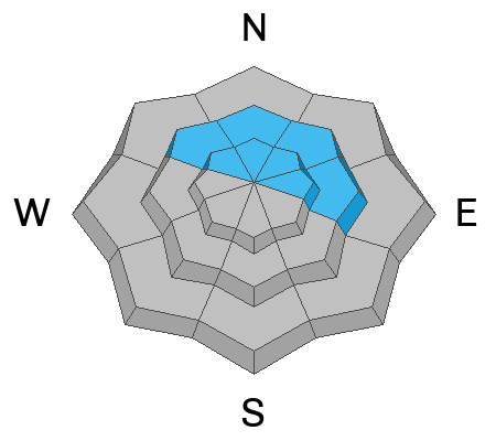
Today there is a CONSIDERABLE danger of triggering an avalanche in wind drifted snow near treeline and above on slopes that face NW-N-NE-E. There is a MODERATE danger of triggering a wind slab on all other slopes.
A buried persistent weak layer of faceted snow exists on slopes that face NW-N-NE-E near treeline and above. There is a CONSIDERABLE danger for this type of avalanche and human triggered avalanches are LIKELY on these slopes.
With very heavy PI rates this morning, the new snow will be quite sensitive. Human triggered avalanches in the new snow are POSSIBLE on all steep slopes
Low
Moderate
Considerable
High
Extreme
Learn how to read the forecast here
Special Announcements
Geyser Pass Road: The road is not plowed and you will need 4x4 and good tires to get up today.
Grooming: Gold Basin through Geyser Pass were groomed on Thursday.
Weather and Snow
6:00 a.m. Snow and Weather Data
24 Hour Snow 3" 72 Hour Snow 3" Season Total Snow 201" Base Depth at Gold Basin 71"
Winds on Pre Laurel Peak S 42 G 60 Temp 21 F

Weather
The storm is here and the main frontal passage is occurring as I write this. The heaviest snowfall rates will occur between now and the early afternoon. Storm totals should be 12-15" by tonight. SW winds will be absolutely howling with sustained speeds of 45-50 mph and gusts up to 70 mph. Winds will decrease after the frontal passage and back off to around 30-40 mph late this afternoon and evening. Light snow showers continue tonight with maybe another 2-4". Thursday is windy again as moist SW flow returns as the next low pressure system drops south along the West coast. Snow develops late Thursday into Friday with chances for some decent accumulation. We see a short break in the action on Saturday, and another system is lined up to bring more snow to the La Sals on Sunday.

General Conditions
Skiing conditions will be improving today as the snow piles up. Unfortunately, the new snow comes with nuking winds and it's gonna be a rough one out there today. Fresh slabs of wind drifted snow will be developing on all aspects and elevation bands. On Northerly aspects, these wind drifts will form on top of a buried weak layer of facets. This storm will be the first real test for this weak layer. I spent the day Monday investigating these facets and you can read my report here. Backcountry travelers also need to be aware of instabilities developing in the new snow as intense snowfall rates occur throughout the morning.

Snowpack and Weather Data
Gold Basin Storm Stake (10,000')
Gold Basin SNOTEL site (10,000')
SNOTEL site near Geyser Pass Winter Trailhead (9600')
Wind Station on Pre-Laurel Peak (11,400')
NWS forecast for the La Sal Mountains.
Recent Avalanches
No new avalanches have been reported. See the La Sal Avalanche database here.
Ad
Avalanche Problem #1
Wind Drifted Snow
Type
Location
Likelihood
Size
Description
Very strong winds are blowing at all elevations today. With heavy snow in the forecast, you can expect to find fresh slabs of wind drifted snow on all aspects in the mountains today. Freshly formed drifts will be sensitive and easy to trigger. The deepest and most dangerous drifts will be primarily found on leeward slopes that face NW-N-NE-E-SE. In some cases these deeper drifts will form on top of weak snow that exists on Northerly facing slopes. On these slopes any triggered wind drift can step down to the buried weak layer and cause a deeper and more dangerous avalanche.
Backcountry travelers should avoid any wind drifted slopes that appear fat, pillowy, round, and smooth.
Avalanche Problem #2
Persistent Weak Layer
Type
Location
Likelihood
Size
Description
A weak layer of sugary faceted snow formed during a dry period earlier this month, and was buried by the Valentine's Day storm that dropped a foot of low density snow. This weak snow exists on Northerly facing slopes near treeline and above. The distribution is somewhat spotty - meaning we are finding it on some slopes, and not on others. The weak snow is especially pockety in nature above treeline where strong winds have destroyed it on some slopes, and left it undisturbed on others. Because of this, the only way to know where it exists is to get out your shovel and dig.
We know this weak snow exists on Northerly aspects, but I have some uncertainty of how it will react to this storm. My mindset for this problem is "guilty until proven innocent." In other words, we should dial back our terrain choices and see how this weak layer reacts to the new load of recent and wind drifted snow. Travel advice is to avoid avalanche terrain on Northerly facing slopes.
Avalanche Problem #3
New Snow
Type
Location
Likelihood
Size
Description
Snowfall rates are forecast to be two inches per hour or even greater during the frontal passage today. With such high PI rates in the forecast, I expect the storm snow to be quite sensitive this morning. Storm slab avalanches and loose snow sluffs will be possible in steep terrain today. You can use small, steep test slopes to gauge the sensitivity of the new snow.
You can avoid this problem by staying out of steep terrain while the storm snow piles up today.
Additional Information
Are you wondering how cell phones and other electronic devices can interfere with your avalanche transceiver? The "20/50 Rule" is that you want your beacon 20cm (8") away from other electronics while transmitting and 50cm (20") away from electronics while searching. Get the full scoop here.
General Announcements
This forecast is from the U.S.D.A. Forest Service, which is solely responsible for its content. This forecast describes general avalanche conditions and local variations always occur. This forecast will be updated by 7:30 tomorrow morning.