Forecast for the Moab Area Mountains

Dave Garcia
Issued by Dave Garcia for
Tuesday, February 21, 2023
A powerful winter storm is moving into the La Sals later today. Be aware of changing conditions and a rising avalanche danger in the coming days.
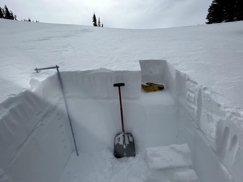
Today the avalanche danger is MODERATE for slabs of wind drifted snow that exist near treeline and above on slopes that face NW-N-NE-E. This danger also exists above treeline on slopes that face SE. In some of these areas, wind slabs may be overlying a layer of weak, sugary, faceted snow and human triggered avalanches 1'-2' deep are possible. Most other terrain has generally LOW danger.
Low
Moderate
Considerable
High
Extreme
Learn how to read the forecast here
Special Announcements
Geyser Pass Road: The road is plowed and the surface is snowpacked.
Grooming: Gold Basin through Geyser Pass were groomed on Thursday.
Weather and Snow
6:00 a.m. Snow and Weather Data
24 Hour Snow 0" 72 Hour Snow 0" Season Total Snow 198" Base Depth at Gold Basin 71"
Winds on Pre Laurel Peak S 26-31 Temp 24 F

Weather
Cloud cover will increase today ahead of a powerful storm that is moving into our area tonight. SW winds will be on the increase as the day goes on blowing 25-30 with gusts up to 40. Snowfall begins around dinner time tonight. The heaviest snowfall will occur Wednesday morning as large-scale ascent will continue to maximize over the forecast area as the low begins to lift across eastern Utah and western Colorado. Jet dynamics, abundant moisture, and favorable southwest flow will see snow intensity increase across the mountains from Wednesday morning onwards with rates exceeding 1 to potentially 2 inches per hour at times. The La Sals should pick up 12-15" of snow by Wednesday night. The peak of the storm on Wednesday comes with very strong SW winds blowing 40-45 and gusts will exceed 55 mph. After a short break in the action, another wave will bring snow Thursday night into Friday, with even more chances for snow into the weekend.

General Conditions
The overall snow surface leaves something to be desired right now, but that's all about to change. The recent string of warm temperatures and sunshine has left dense, well consolidated snow in sheltered areas. Open terrain near and above treeline is quite variable with a mix of occasional dense loose, hard wind scoured crusts, old hard wind slabs, and recent soft wind drifts. Your primary avalanche concern today is old deposits of wind drifted snow on Northerly facing slopes near treeline and above. In some cases, these older wind slabs sit on top of weak faceted snow that formed during a recent dry period in the middle of February. This weak layer of faceted snow is buried under the foot of snow that fell early last week. It has yet to produce any avalanches, but we may see it become active with incoming heavy snow and very strong winds. I spent the day yesterday investigating this weak layer and you can read my report here.

Snowpack and Weather Data
Gold Basin Storm Stake (10,000')
Gold Basin SNOTEL site (10,000')
SNOTEL site near Geyser Pass Winter Trailhead (9600')
Wind Station on Pre-Laurel Peak (11,400')
NWS forecast for the La Sal Mountains.
Recent Avalanches
No new avalanches have been reported. See the La Sal Avalanche database here.
Ad
Avalanche Problem #1
Wind Drifted Snow
Type
Location
Likelihood
Size
Description
Old hard drifts that formed over the weekend may still be reactive to the weight of a skier or rider. These hard drifts will appear smooth and round, and sound hollow and drum-like. Older drifts are dangerous, because they generally allow you to get further out on to them before they fail. In some cases, old slabs of wind drifted snow sit on top of weak, sugary, faceted snow that formed earlier this month. This weak snow exists on Northerly facing slopes, and the only way to know for sure is to dig down into the snow and look for it.
Avalanche Problem #2
Persistent Weak Layer
Type
Location
Likelihood
Size
Description
A weak layer of sugary faceted snow formed during a dry period earlier this month, and was buried by the Valentine's Day storm that dropped a foot of low density snow. This weak snow exists on Northerly facing slopes near treeline and above. The distribution is somewhat spotty - meaning we are finding on some slopes, and not others. The weak snow is especially pockety in nature above treeline where strong winds have destroyed it on some slopes, and left it undisturbed on others. Because of this, the only way to know where it exists is to get out your shovel and dig.
This layer of weak snow has yet to produce any avalanches, but the incoming storm with heavy snow and strong winds is the perfect recipe to develop a slab and put some real pressure on these facets. As the storm intensifies, we are likely to see avalanches failing on this layer.
The weak layer of facets is seen in this photo after a compression test produced a CT13 SP.
Additional Information
Are you wondering how cell phones and other electronic devices can interfere with your avalanche transceiver? The "20/50 Rule" is that you want your beacon 20cm (8") away from other electronics while transmitting and 50cm (20") away from electronics while searching. Get the full scoop here.
General Announcements
This forecast is from the U.S.D.A. Forest Service, which is solely responsible for its content. This forecast describes general avalanche conditions and local variations always occur. This forecast will be updated by 7:30 tomorrow morning.