Forecast for the Moab Area Mountains

Eric Trenbeath
Issued by Eric Trenbeath for
Saturday, February 16, 2019
Heavy snowfall accompanied by strong winds have created dangerous avalanche conditions. The avalanche danger is CONSIDERABLE on steep, wind drifted slopes, and human triggered avalanches are likely on all aspects at upper elevations. On slopes that face NW-N-E, the new snow load has also increased the danger for triggering a deep and dangerous avalanche failing on a buried, persistent weak layer. Most low elevation, and south facing terrain below treeline has a MODERATE danger. Backcountry travelers today need to have excellent route finding and snow stability analysis skills. Avoid steep, wind loaded terrain.
Low
Moderate
Considerable
High
Extreme
Learn how to read the forecast here
Special Announcements
The latest UAC Podcast was just released: The Message and the Messengers - A Conversation with Alex Hamlin. In this podcast forecaster Drew Hardesty sits down with Alex Hamlin. For over fifteen years, Alex Hamlin has worked at the intersection of storytelling and outdoor sport, with experience at magazines, global retail brands and creative agencies. In the conversation, they talk about the psychology behind marketing (and influencing behavior change), with a particular eye toward marketing safety.
It's been a deadly month or so in Utah with four avalanche fatalities. The accident reports are all finalized with some first-hand accounts, and are all worth reading. We all have something to learn so that we can get home safely to our loved ones.
Jan 18 Electric Lake Accident (Skyline area)
Jan 25 Laurel Peak Accident (Moab area)
Feb 7 Circleville Mtn Accident (Southwest area near Beaver, UT)
Feb 9 Chalk Creek Accident (Western Uintas)
Weather and Snow
Light snow began to fall after 5:00 a.m. and as of 7:00 we've picked up about 2" of low density snow. Another 2"-4" are possible today. I again unfortunately don't have any current Pre Laurel wind data. This is apparently a server issue. SW winds yesterday blew in the 20-25 mph range with average gusts in the upper 30's. They'll swing around to the NW today averaging 15-25 mph with gusts to 35. High temps today are only going to reach around 10 degrees, and with the cold NW wind, it's going to be frigid out. The next round of snow should arrive sometime tomorrow with what looks like at least another 6" by Monday. Stay tuned.
I was down in the Abajo Mountains yesterday where Dustin Randall from ROAM Industry and I found up to a foot of dense, somewhat inverted powder skiing in and around the old Blue Mountain ski area. In spite of the low elevation, we found areas with wind slab in exposed locations. Moderate to strong winds up high were moving snow around and the snow surface was definitely being wind affected. Riders in the La Sals reported deep snow with the consistency of "cream cheese" providing lots of opportunities for getting stuck.

New snow totals in Gold Basin (10,000')
Snow totals at the Geyser Pass Trailhead (9600')
Wind, temperature, and humidity on Pre Laurel Peak (11,700')
National Weather Service point forecast.
Ad
Avalanche Problem #1
Wind Drifted Snow
Type
Location
Likelihood
Size
Description
Wind drifted snow continues to be our primary concern. The most recent snow has blown into deep, dense drifts along upper elevation ridge crests, and even down into mid elevattions, primarily on slopes that face NW-N-E. But a shift in wind direction today will also deposit snow on to southerly aspects at upper elevations. Avoid slopes with recent deposits of wind drifted snow recognizable by their smooth, rounded appearance. Cracking in the snow surface is a sign of instability.
Avalanche Problem #2
Persistent Weak Layer
Type
Location
Likelihood
Size
Description
The most recent snow load will be a good test for buried persistent weak layers in the snowpack. Hopefully I and others will have some visibility at some point to see if there has been any recent, deep, avalanche activity. Our primary layer of concern continues to be the early December snow that has turned into weak, sugary facets on top of the October crust. Where the snowpack is deepest, this layer is mostly non-reactive. Where the pack is shallow and weak, alarming results occasionally pop up. I think we are rounding the bend, but at this point, I'm still going to assume that deep and dangerous, human triggered avalanches, failing on a buried persistent weak layer are still possible.
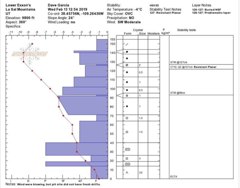
Dave Garcia's pit profile from Wednesday. Our most problematic layer continues to be December facets at around 70 cms. For more details see his observation.
General Announcements
Your information can save lives. If you see anything we should know about, please help us out by submitting snow and avalanche observations HERE. You can also call me at 801-647-8896, or send me an email: [email protected].
Support the UAC through your daily shopping. When you shop at Smith's, or online at REI, Backcountry.com, Patagonia, NRS, Amazon, eBay by clicking on these links, they donate a portion of your purchase to the UAC. If you sell on eBay, you can have your See our Affiliate Page for more details on how you can support the UAC when you shop
This advisory is from the U.S.D.A. Forest Service, which is solely responsible for its content. This advisory describes general avalanche conditions and local variations always occur.