Forecast for the Moab Area Mountains

Dave Garcia
Issued by Dave Garcia for
Tuesday, February 13, 2024
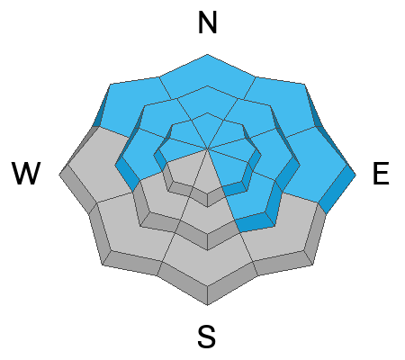
The avalanche danger is CONSIDERABLE on above treeline slopes that face NW-N-NE-E where humans are LIKELY to trigger deep and dangerous avalanches failing on a buried persistent weak layer (PWL).

These large avalanches failing on the PWL are POSSIBLE near treeline and below on Northerly aspects and on slopes that face W and SE where there is a MODERATE danger.
Slopes that face S and SW offer LOW avalanche danger.
Low
Moderate
Considerable
High
Extreme
Learn how to read the forecast here
Special Announcements
Monday, February 12 marked the 31st anniversary of the tragic Talking Mountain Cirque avalanche accident where six backcountry skiers were buried, and four, including the La Sal avalanche forecaster, were killed. The town of Moab was devastated, and the impacts are still felt today. It is worth your time to Read the report here.
Road Conditions: The Geyser Pass Road is plowed.
Grooming: Trails are groomed with classic track.
Weather and Snow
6:00 a.m. Snow and Weather Data
24 Hour Snow 0" 72 Hour Snow 0" Season Total Snow 131" Depth at Gold Basin 53"
Winds on Pre-Laurel Peak: NW 3-6 Temp 11° Percent of Normal: 107%

Weather
Another beautiful sunny day is in store for the La Sals. We will see clear skies, plenty of sunshine, and high temperatures in the mid-twenties. Winds will remain light, and blow out of the SW at 5-15 mph. Tomorrow looks to be more of the same. On Thursday partial cloud cover moves in with breezy conditions. The next chance for snow looks to be early next week.
General Conditions
Expect to find shallow, soft, settled powder conditions combined with picture-perfect weather. Close to three feet of snow has fallen since February 1, and overall coverage is excellent. Yesterday, I toured up to Red Snow Cirque and found great skiing on low-angle North facing terrain. Each day we continue to find avalanches that ran during the two rounds of natural activity on 2/2 and 2/7. Numerous avalanches from 3'-6' deep have been observed, primarily on NW-N-NE-E aspects above treeline, but activity has also been observed near treeline and below, and on West aspects. Buried persistent weak layers of facets remain the number one avalanche concern. The likelihood of triggering a deep and dangerous avalanche is slowly decreasing but we still need to give things a little more time to adjust, especially on steep, northerly aspects.
Snowpack and Weather Data
Gold Basin Storm Stake (10,000')
Gold Basin SNOTEL site (10,000')
SNOTEL site near Geyser Pass Winter Trailhead (9600')
Wind Station on Pre-Laurel Peak (11,400')
NWS forecast for the La Sal Mountains.
Recent Avalanches
Since February 2, there have been 16 avalanches that we know about. Most of these broke deep on the November or December facet layers. We continue to update the La Sal Avalanche Database and you can See the full list here. Below is a heat map showing recent avalanches from 2/2 - 2/7.
During my travels yesterday, I ran across this natural avalanche that failed on a steep NW facing slope in the middle of the Funnel and ran all the way to the bottom of the drainage.
On Sunday, February 11, a backcountry skier was caught and killed in an avalanche in the Anthracite Range, near the town of Crested Butte. The avalanche was triggered on a very steep north-facing slope at 11,200 feet. Our deepest condolences to the deceased skier's family, friends, and community. You can read the preliminary accident report here. The Anthracite Range has a very similar snowpack as the La Sals, with PWL as the main problem type.
Ad
Avalanche Problem #1
Persistent Weak Layer
Type
Location
Likelihood
Size
Description
Persistent weak layers that formed in November and December produced numerous deep and dangerous avalanches over the past 10 days. These avalanches ran during a period of high danger. Most avalanche accidents happen after the natural cycle is over, when the danger is dropping down to considerable, and eventually moderate. The natural activity may be over, but many slopes hang in the balance just waiting for a skier or rider to come along and trigger deep, dangerous, and deadly avalanches. The danger is most pronounced on above treeline slopes that face NW-N-NE-E. Humans are likely to trigger large avalanches on these slopes, especially in steep rocky terrain with a shallow snowpack. The snowpack is slowly gaining strength, but we need to give it more time to adjust. Continue to practice conservative decision making, and stick to slopes less than 30 degrees.
Additional Information
Want some more insight into the La Sal Mountains as well as the communal impacts of a tragic avalanche? Check out the latest UAC podcast with forecaster Eric Trenbeath where he discusses the range, it's often treacherous snowpack, and how the devastating avalanche in February, 1992, affected the Moab community.
Our avalanche beacon checker sign and beacon training park are up and running. A huge thanks to Talking Mountain Yurts for sponsoring those this season!
Sign up for forecast region-specific text message alerts. You will receive messages about changing avalanche conditions, watches, warnings and road plowing closures.
Follow us on Instagram @utavy_moab
General Announcements
This forecast is from the U.S.D.A. Forest Service, which is solely responsible for its content. This forecast describes general avalanche conditions and local variations always occur.