Forecast for the Moab Area Mountains

Dave Garcia
Issued by Dave Garcia for
Wednesday, February 14, 2024
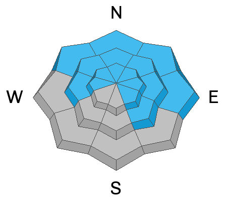
The avalanche danger is MODERATE. Deep, dangerous, and potentially deadly avalanches 3-6 feet deep, failing on a buried persistent weak layer remain POSSIBLE on steep slopes that face W-N-SE. The odds of triggering a slide have dropped, but the consequences remain the same. These are large, hard-slab avalanches that will easily ruin your day, or worse.
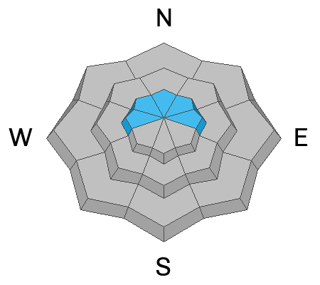
An uptick in Southerly winds has produced a round of soft, shallow slabs of wind-drifted snow that will be sensitive to the weight of a rider above treeline on slopes that face W-N-E.
Slopes that face S and SW offer a LOW danger.
Low
Moderate
Considerable
High
Extreme
Learn how to read the forecast here
Special Announcements
Monday, February 12 marked the 31st anniversary of the tragic Talking Mountain Cirque avalanche accident where six backcountry skiers were buried, and four, including the La Sal avalanche forecaster, were killed. The town of Moab was devastated, and the impacts are still felt today. It is worth your time to Read the report here.
We are seeking a passionate individual to join us as Executive Director of the nonprofit Utah Avalanche Center. Click here for more information.
Road Conditions: The Geyser Pass Road is plowed.
Grooming: Trails are groomed with classic track.
Weather and Snow
6:00 a.m. Snow and Weather Data
24 Hour Snow 0" 72 Hour Snow 0" Season Total Snow 131" Depth at Gold Basin 52"
Winds on Pre-Laurel Peak: 21 G 28 SW Temp 24° Percent of Normal: 105%

Weather
We can expect plenty of sunshine today with high temperatures around 25 degrees. Winds out of the SW will blow 15-20 mph, and will increase to 20-25 mph tonight. Unsettled conditions will bring snow to the Northern mountains on Thursday. We will see scattered clouds with small chances for snow flurries with no real accumulation. Winds will remain elevated for the next couple days.
General Conditions
Close to three feet of snow has fallen since February 1, and overall coverage is excellent. Southerly winds were on the increase yesterday and blew in the moderate range overnight. These are perfect wind speeds to move snow around, and you may encounter shallow soft slabs of wind-drifted snow above treeline today. Additionally, the great powder skiing we've enjoyed lately may be slightly wind-affected. Solar aspects will be crusted over. Yesterday, we found great skiing in soft, settled powder on Northerly aspects up in Middle Cirque. Be sure to read Charlie Ramser's excellent report of our travels. During the past week, numerous avalanches from 3'-6' deep have been observed, primarily on NW-N-NE-E aspects above treeline, but activity has also been observed near treeline and below, and on West aspects. Buried persistent weak layers (PWL) of facets remain the number one avalanche concern. The likelihood of triggering a deep and dangerous avalanche has decreased, but the size has not. Any avalanche triggered on the PWL would be large and potentially unsurvivable.
Snowpack and Weather Data
Gold Basin Storm Stake (10,000')
Gold Basin SNOTEL site (10,000')
SNOTEL site near Geyser Pass Winter Trailhead (9600')
Wind Station on Pre-Laurel Peak (11,400')
NWS forecast for the La Sal Mountains.
Recent Avalanches
Since February 2, there have been 16 avalanches that we know about. Most of these broke deep on the November or December facet layers. We continue to update the La Sal Avalanche Database and you can See the full list here.
The term "low probability, high consequence" is used a lot. When we say "high consequence" this is what we mean:
On Sunday, February 11, a backcountry skier was caught and killed in an avalanche in the Anthracite Range, near the town of Crested Butte. The avalanche was triggered on a very steep north-facing slope at 11,200 feet. Our deepest condolences to the deceased skier's family, friends, and community. You can read the preliminary accident report here. The Anthracite Range has a very similar snowpack to the La Sals, with PWL as the main problem type.
Ad
Avalanche Problem #1
Persistent Weak Layer
Type
Location
Likelihood
Size
Description
Persistent weak layers that formed in November and December produced numerous deep and dangerous avalanches going back to February 2. These avalanches ran during a period of high danger. Most avalanche accidents happen after the natural cycle is over, when the danger is dropping down to considerable, and eventually moderate. The natural activity may be over, but many slopes hang in the balance just waiting for a skier or rider to come along and trigger deep, dangerous, and deadly avalanches. The danger is most pronounced in areas with a shallow snowpack. Steep rocky terrain, and slopes that typically get wind-scoured are likely places to trigger an avalanche. Areas that have previously avalanched are also suspect.
Here's how I am handling this:
I am continuing to evaluate the snow and terrain carefully. I am slowly biting off pieces of terrain. Nibbling at the edges before I go all in. I am probing the snowpack to be sure that I am skiing in areas with deep snow. I am ok with some overhead hazard, but I am generally keeping my slope angles low. I am choosing terrain that has gradual transitions and I am avoiding complex terrain with terrain traps and cliff bands. Remember that during moderate danger with a PWL, deep and dangerous human-triggered avalanches remain possible.
Avalanche Problem #2
Wind Drifted Snow
Type
Location
Likelihood
Size
Description
In our fieldwork yesterday we did observe any recent wind-slab formation. However, these Southerly winds are sustained enough that shallow slabs of wind-drifted snow may exist above treeline. This should be pretty straightforward today. These sensitive slabs will be found on the shady side of the compass, and should break right at our feet. Look for and avoid any recently drifted areas that appear fat, round and pillowy.
Additional Information
Want some more insight into the La Sal Mountains as well as the communal impacts of a tragic avalanche? Check out the latest UAC podcast with forecaster Eric Trenbeath where he discusses the range, it's often treacherous snowpack, and how the devastating avalanche in February, 1992, affected the Moab community.
Our avalanche beacon checker sign and beacon training park are up and running. A huge thanks to Talking Mountain Yurts for sponsoring those this season!
Sign up for forecast region-specific text message alerts. You will receive messages about changing avalanche conditions, watches, warnings and road plowing closures.
Follow us on Instagram @utavy_moab
General Announcements
This forecast is from the U.S.D.A. Forest Service, which is solely responsible for its content. This forecast describes general avalanche conditions and local variations always occur.