Forecast for the Moab Area Mountains

Eric Trenbeath
Issued by Eric Trenbeath for
Monday, February 12, 2024
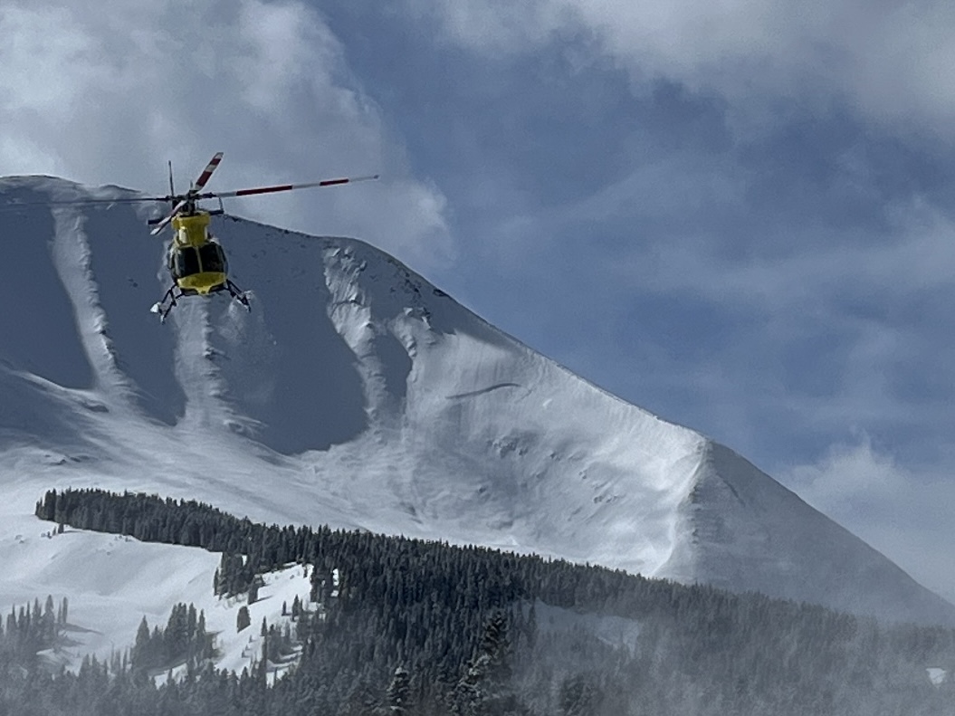
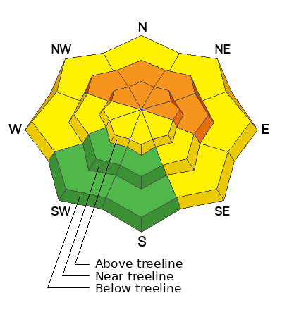
The avalanche danger remains CONSIDERABLE on steep slopes that face NW-N-NE-E near and above treeline. Although the odds are slowly decreasing, human triggered avalanches 3'-6' deep, failing on a buried persistent weak layer remain likely. Continue to avoid steep, northerly facing terrain.

A MODERATE danger exists on W and SE facing slopes, and on low elevation northerly aspects. In these areas, human triggered avalanches failing on a buried persistent weak layer are possible.
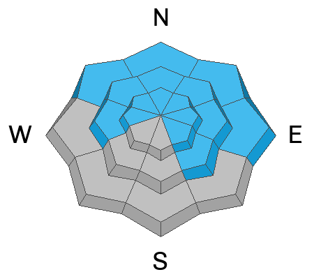
Most S and SW facing terrain has generally LOW danger with the exception of maybe some isolated, shallow fresh slabs of wind drifted snow above treeline. We may also see some rollerballs or pinwheels on sun exposed slopes today but they shouldn't pose much of a threat.
Low
Moderate
Considerable
High
Extreme
Learn how to read the forecast here
Special Announcements
Today marked the 31st anniversary of the tragic Talking Mountain Cirque avalanche accident where six backcountry skiers were buried, and four, including the La Sal avalanche forecaster were killed. The town of Moab was devastated, and the impacts are still felt today. Read the report here.
Road Conditions: The Geyser Pass Road is plowed.
Grooming: Trails are groomed with classic track.
Weather and Snow
6:00 a.m. Snow and Weather Data
24 Hour Snow 0" 72 Hour Snow 8" Season Total Snow 131" Depth at Gold Basin 55"
Winds on Pre-Laurel Peak: NW 10-20 Temp 14° Percent of Normal: 110%

Weather
Another sunny day is on tap with slightly warmer temperatures than yesterday. Highs at 10,000' will be in the upper 20's, and winds will be mostly light from the NW. Dry weather and gradually warming temperatures continue through mid-week.
General Conditions
It was an all time weekend in the mountains with fresh powder, cool temps, and light winds. A bluebird day yesterday capped off a 10 day period of off and on stormy weather. In our travels yesterday, we found great powder skiing and mostly stable conditions on southerly aspects but alas, a strong sun dampened the surface in these areas and they will likely be crusted over today. Great snow can still be found on shady aspects. Read my full report here.
Since Feb 1, close to 3' of snow has fallen containing 3.0" Snow Water Equivalent (SWE). The load proved to be too much for underlying persistent weak layers to bear, and we experienced two rounds of natural avalanche activity. The first round occurred on Feb 2, and the second on Feb 7. Numerous avalanches from 3'-6' deep have been observed, primarily on NW-N-NE-E aspects above treeline, but activity has also been observed near treeline and below, and on west aspects. The likelihood of triggering a deep and dangerous avalanche is slowly decreasing but we still need to give things a little more time to adjust, especially on steep, northerly aspects.
Check out the "Week in Review" video below for skiing and avalanche highlights.
Snowpack and Weather Data
Gold Basin Storm Stake (10,000')
Gold Basin SNOTEL site (10,000')
SNOTEL site near Geyser Pass Winter Trailhead (9600')
Wind Station on Pre-Laurel Peak (11,400')
NWS forecast for the La Sal Mountains.
Recent Avalanches
Many natural avalanches and one large, likely human triggered avalanche have occurred since Feb 2. See the full list here.
While working with GCSAR on Saturday, I took this photo of Classic Helicopters with an avalanche on the north face of Mount Mellenthin that likely ran on Wednesday. The crown line runs all the way down to the observer's right shoulder of the ridge.
Ad
Avalanche Problem #1
Persistent Weak Layer
Type
Location
Likelihood
Size
Description
Persistent weak layers that formed in November and December produced numerous deep and dangerous avalanches over the past 10 days. Although the odds are slowly decreasing, human triggered avalanches 3'-6' deep failing on these weak layers remain likely on steep slopes facing NW-N-NE-E. The likelihood is less on slopes facing west or southeast but dangerous avalanches are still possible in these areas. We are also starting to observe some weak, faceted layers higher up in the snowpack. We have some uncertainty about how widespread these layers are distributed. Mostly stable weather conditions and warmer temperatures this week will help things heal. Give the snowpack time to adjust. Continue to practice conservative decision making, and stick to slopes less than 30 degrees.
Avalanche Problem #2
Wind Drifted Snow
Type
Location
Likelihood
Size
Description
Light to moderate north and easterly winds moved a little snow around yesterday at the highest elevations. We really didn't find much slab development in our travels, but be on the lookout for shallow, fresh drifts on all aspects above treeline today. Slabs of drifted snow form on the leeward sides of ridge crests and terrain features such as gully walls and sub-ridges. They may have a smooth, rounded appearance and cracking is a sign of instability.
On steep northerly aspects, fresh drifting will only exacerbate the persistent weak layer problem and these areas should simply be avoided.
Additional Information
Want some more insight into the La Sal Mountains as well as the communal impacts of a tragic avalanche? Check out the latest UAC podcast with forecaster Eric Trenbeath where he discusses the range, it's often treacherous snowpack, and how the devastating avalanche in February, 1992, affected the Moab community.
Our avalanche beacon checker sign and beacon training park are up and running. A huge thanks to Talking Mountain Yurts for sponsoring those this season!
Sign up for forecast region-specific text message alerts. You will receive messages about changing avalanche conditions, watches, warnings and road plowing closures.
Follow us on Instagram @utavy_moab
General Announcements
This forecast is from the U.S.D.A. Forest Service, which is solely responsible for its content. This forecast describes general avalanche conditions and local variations always occur.