Forecast for the Moab Area Mountains

Dave Garcia
Issued by Dave Garcia for
Wednesday, February 1, 2023
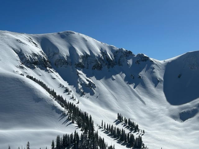
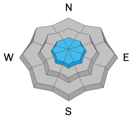
Strong Northerly winds have whipped up another round of fresh wind drifts, and you will find a MODERATE danger for triggering avalanches in wind drifted snow on all aspects above treeline.
In non-wind-affected terrain, the avalanche danger is generally LOW.
Low
Moderate
Considerable
High
Extreme
Learn how to read the forecast here
Special Announcements
Geyser Pass Road: The road remains closed as crews continue digging out. Road work should be completed today with a scheduled opening tomorrow.
Weather and Snow
24 Hour Snow 0" 72 Hour Snow 5" Season Total Snow 183" Base Depth at Gold Basin 75"
Winds on Pre Laurel Peak NW 10 Temp 2 F

Weather
It should be a gorgeous day in the mountains with cold temperatures and lots of sunshine. Temperatures are reading 2 degrees this morning, and we can expect a high of around 10 degrees. NW winds will blow 10 mph. A dry NW flow will keep us sunny and cold all week as high pressure builds in from the west. The next chance for snow will be on Monday.

General Conditions
Five inches of snow fell on Monday night and has greatly improved turning and riding conditions. Solar aspects saw full sunshine yesterday and will most likely be crusted over today. You will still find cold, low density powder on shady aspects out of the wind zone. Erratic Northerly winds blew in the Moderate range all day yesterday and easily transported the five inches of cold smoke. I witnessed Moderate to Intense snow transport loading all aspects in the Alpine. Fresh slabs of wind drifted snow above treeline are your primary avalanche concern today.
For more information on my fieldwork from Monday and Tuesday see my observations here.

Snowpack and Weather Data
Gold Basin Storm Stake (10,000')
Gold Basin SNOTEL site (10,000')
SNOTEL site near Geyser Pass Winter Trailhead (9600')
Wind Station on Pre-Laurel Peak (11,400')
NWS forecast for the La Sal Mountains.
Recent Avalanches
Yesterday I observed numerous small dry loose avalanches in steep Northerly terrain. See the La Sal Avalanche database here.
A small dry loose snow avalanche in Talking Mountain Cirque.
Ad
Avalanche Problem #1
Wind Drifted Snow
Type
Location
Likelihood
Size
Description
Yesterday ridgetop winds blew in the Moderate range for most of the day and shifted from WNW to ENE and back again. I observed impressive amounts of snow transport all day long as these shifting Northerly winds had a very easy time moving the five inches of low density snow. Be on the lookout for freshly formed slabs of wind drifted snow on all aspects above treeline. Expect these newly formed slabs to be quite sensitive and easy to trigger. Shooting cracks in drifted snow are a sure sign of instability.
Older, harder drifts that formed over the weekend exist on Northerly facing slopes. These hard slabs are dangerous because they can allow you to get further down a slope before they break well above you. Hard drifts often produce hollow, drum-like sounds when you walk out on them. Any steep slopes that have a smooth, rounded, fat appearance should be avoided.
The small avalanche in this photo is a pocket of wind drifted snow that slid above Tele Gold. Notice how fat, rounded, and pillowy most of the snow appears in this photo. These slopes are obviously wind loaded. Any steeps slopes that look like this should be avoided.
Avalanche Problem #2
Normal Caution
Type
Location
Likelihood
Size
Description
The likelihood of triggering an avalanche on the buried persistent weak layer that formed in November has become so low that we have removed that problem from our forecast. Keep in mind that avalanches involving new and wind drifted snow can be just as serious, especially if you find yourself in bigger alpine terrain. Consider your terrain choices carefully, and be aware of what the consequences are. Always practice safe travel techniques under all conditions. Safe travel techniques include:
  • Only expose one member of the party at a time to avalanche terrain. The rest of the party should be in a safe spot with eyes on the skier or rider in the avalanche path.
  • Have an escape route or "Plan B" in your head if an avalanche were to happen.
  • Never ski above others parties in avalanche terrain. Keep open lines of communication with other touring parties.
  • Consider the consequences of your terrain choices. What will happen if the slope slides? What is below you? What are you connected to?
  • Continue to evaluate the snowpack and gather as much information as possible. Use test slopes that are representative of the terrain you wish to ski.
Additional Information
General Announcements
This forecast is from the U.S.D.A. Forest Service, which is solely responsible for its content. This forecast describes general avalanche conditions and local variations always occur. This forecast will be updated by 7:30 tomorrow morning.