Forecast for the Moab Area Mountains

Dave Garcia
Issued by Dave Garcia for
Tuesday, January 31, 2023
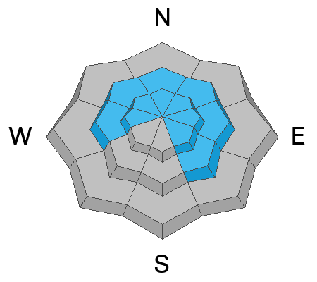
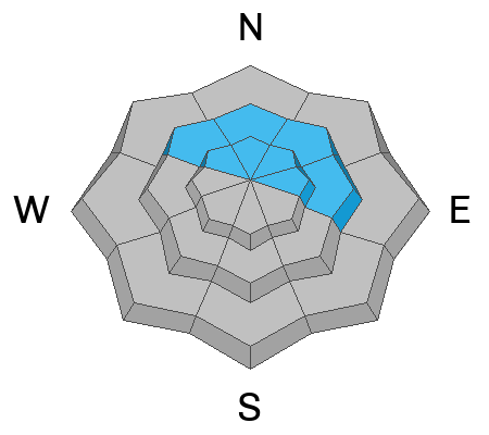
A MODERATE danger exists for human triggered avalanches involving both old and fresh slabs of wind drifted snow on steep slopes near and above treeline that face W-N-SE.

In non-wind affected terrain the avalanche danger is generally LOW.

Human triggered avalanches failing on a buried persistent weak layer are unlikely. They may still be possible on Northerly facing slopes in thinner snowpack areas, and in areas of very steep, rocky, radical terrain.
Low
Moderate
Considerable
High
Extreme
Learn how to read the forecast here
Special Announcements
Geyser Pass Road: The road remains closed as crews continue digging out. Work is expected to continue through Wednesday.
Weather and Snow
24 Hour Snow 5" 72 Hour Snow 5" Season Total Snow 183" Base Depth at Gold Basin 78"
Winds on Pre Laurel Peak NW 10 Temp -4 F

Weather
It is a cold, crisp morning in Gold Basin. Temperatures are reading - 4 degrees, and we can expect a high of around 9 degrees today. NW winds will blow 10-15 miles per hour, keeping wind chill values sub-zero. Cloud cover this morning will decrease as the day goes on. A dry NW flow will keep us sunny and cold all week as high pressure builds in from the west. The next chance for snow will be on Monday.

General Conditions
Five inches of new snow will really help the skiing conditions. In my travels yesterday, I found the snow to be wind affected and dense in open terrain near treeline. I observed blowing and drifting snow near treeline and above, and wind drifted snow will be your primary avalanche problem today. The overall snowpack is deep and strong with average depths ranging from 7'-9'. Deep avalanches, failing on the November persistent weak layer are unlikely but may still be possible in outlying areas where the snowpack is less than 5' deep, with the greatest likelihood existing in very steep, rocky, radical terrain.
For more snowpack information see a complete list of observations here.

Snowpack and Weather Data
Gold Basin Storm Stake (10,000')
Gold Basin SNOTEL site (10,000')
SNOTEL site near Geyser Pass Winter Trailhead (9600')
Wind Station on Pre-Laurel Peak (11,400')
NWS forecast for the La Sal Mountains.
Recent Avalanches
Ad
Avalanche Problem #1
Wind Drifted Snow
Type
Location
Likelihood
Size
Description
SW winds continued to blow as the five inches of new snow piled up yesterday evening. Backcountry travelers should expect to encounter freshly formed soft slabs of wind drifted snow near and above treeline today. Fresh drifts will be found primarily on leeward slopes, but be on the lookout for terrain features like gullies, chutes, and sub ridges that can channel winds and become cross loaded.
Older, harder drifts that formed over the weekend exist on Northerly facing slopes. These hard slabs are dangerous because they can allow you to get further down slope before they break well above you. Any steep slopes that have a smooth, rounded, fat appearance should be avoided.
Avalanche Problem #2
Persistent Weak Layer
Type
Location
Likelihood
Size
Description
The La Sal snowpack is now generally deep and mostly stable with the November persistent weak layer buried far below the surface. Five inches of new snow today will not affect this buried weak layer. Snow pits dug to this depth show that the layer has gained strength, and that the overriding slab is very thick and strong. It is very unlikely that the weight of a skier or rider would trigger a deep avalanche but it still may be possible in outlying areas that have a combination of radical terrain and a thinner, weaker snowpack. If you are venturing into larger terrain, pull out your probe. If the snowpack is 150 cm, or about 5' deep or less, this is where you need to look closer. In these areas, a slab about 3' thick exists over the November PWL, and this structure indicates a higher likelihood for a human triggered avalanches.
Additional Information
General Announcements
This forecast is from the U.S.D.A. Forest Service, which is solely responsible for its content. This forecast describes general avalanche conditions and local variations always occur. This forecast will be updated by 7:30 tomorrow morning.