Join us at our 2nd Annual Blizzard Ball

Forecast for the Moab Area Mountains

Eric Trenbeath
Issued by Eric Trenbeath on
Monday morning, January 30, 2023
Be alert to changing condtions and a potential rise in danger.
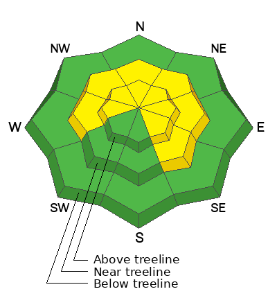
A MODERATE danger exists for human triggered avalanches involving unstable slabs of wind drifted snow on steep slopes near and above treeline that face W-N-SE. Snowfall later today will likely cause the danger to increase as fresh drifts become more widespread. The danger could rise to CONSIDERABLE if we end up with more than about 6" of snow.

In non-wind affected terrain the avalanche danger is generally LOW.

Human triggered avalanches failing on a buried persistent weak layer are unlikely. They may still be possible in thinner snowpack areas, and in areas of very steep, rocky, radical terrain.
Low
Moderate
Considerable
High
Extreme
Learn how to read the forecast here
Special Announcements
Geyser Pass Road: Road widening will resume today and the road will be closed. Work is expected to continue through Wednesday.
Weather and Snow
24 Hour Snow 0" 72 Hour Snow 0" Season Total Snow 178" Base Depth at Gold Basin 73"
Winds on Pre Laurel Peak S 20-25 G30 Temp 18F

Weather
Southerly winds continue to crank averaging 20 mph along ridge tops over the last 24 hours with gusts as high as 40 mph. Today, a slow moving trough will sag gradually southward bringing snow first to the northern Rockies and eventually making it down to the Four Corners region. The system is not set up to bring much snow to the southern mountains but for whatever reason, the NWS forecast for the La Sals is showing anomalous amounts of snow in the 8"-12" range. Most models, and forecasts for surrounding regional mountains are showing only a few inches of snow from this, and I'm thinking 4"-6" are likely with the heaviest snowfall kicking in later today. Clouds and snow showers will linger tonight and winds will finally back off and shift to northwesterly. Dry conditions and slowly warming temps remain through the week.

General Conditions
In my travels yesterday I continued to find soft settled powder out of the wind zone but these areas are diminishing as gusty winds have begun to find their way into mid and even lower elevations. Areas of wind drifted snow, both old and new, continue to be our primary concern today with additional snow creating a corresponding rise in danger. The overall snowpack is deep and strong with average depths ranging from 7'-9'. Deep avalanches, failing on the November persistent weak layer are unlikely but may still be possible in outlying areas where the snowpack is less than 5' deep, with the greatest likelihood existing in very steep, rocky, radical terrain.
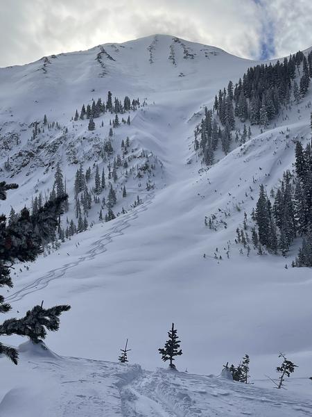
Tim Mathews and company found good powder and stable conditions out of the wind zone on Saturday. The terrain above is where you are likely to find unstable slabs of wind drifted snow. It also qualifies as steep, rocky, radical terrain with a potentially thinner snowpack.
For more snowpack information see a complete list of observations here.

Snowpack and Weather Data
Gold Basin Storm Stake (10,000')
Gold Basin SNOTEL site (10,000')
SNOTEL site near Geyser Pass Winter Trailhead (9600')
Wind Station on Pre-Laurel Peak (11,400')
NWS forecast for the La Sal Mountains.
Recent Avalanches
A few small avalanches involving new and wind drifted snow have been observed over the past several days but have not been detailed. For a further list of avalanches see the La Sal Avalanche database here.
Ad
Avalanche Problem #1
Wind Drifted Snow
Type
Location
Likelihood
Size
Description
Steady winds throughout the week have kept the threat of human triggered avalanches involving wind drifted snow alive, and a few inches or more of new snow later today will increase the danger. In my travels yesterday, I observed blowing and drifting snow at mid and even lower elevations indicating that the problem is becoming more widespread. Slopes with a northerly aspect will see the most wind loading, but crossloading will also be a factor on slopes facing west and southeast. Look for unstable slabs of wind drifted snow on the leeward sides of ridge crests and terrain features such as gully walls and sub-ridges in wind affected terrain. Fresh drifts often have a smooth, rounded appearance and cracking is a sign of instability.
Older drifts that formed over the last few days have stiffened up and are now mostly stuck in place, but steep slopes that have a smooth, rounded, "fat" appearance should still be approached with caution. Consider the consequences of the terrain you are in.
Avalanche Problem #2
Persistent Weak Layer
Type
Location
Likelihood
Size
Description
The La Sal snowpack is now generally deep and mostly stable with the November persistent weak layer buried far below the surface. Snow pits dug to this depth show that the layer has gained strength, and that the overriding slab is very thick and strong. It is very unlikely that the weight of a skier or rider would trigger a deep avalanche but it still may be possible in outlying areas that have a combination of radical terrain and a thinner, weaker snowpack. If you are venturing into larger terrain, pull out your probe. If the snowpack is 150 cm, or about 5' deep or less, this is where you need to look closer. In these areas, a slab about 3' thick exists over the November PWL, and this structure indicates a higher likelihood for a human triggered avalanches.
Additional Information
General Announcements
This forecast is from the U.S.D.A. Forest Service, which is solely responsible for its content. This forecast describes general avalanche conditions and local variations always occur. This forecast will be updated by 7:30 tomorrow morning.