UDOT PLANNED AVALANCHE CLOSURES!!

Forecast for the Moab Area Mountains

Eric Trenbeath
Issued by Eric Trenbeath for
Sunday, December 30, 2018
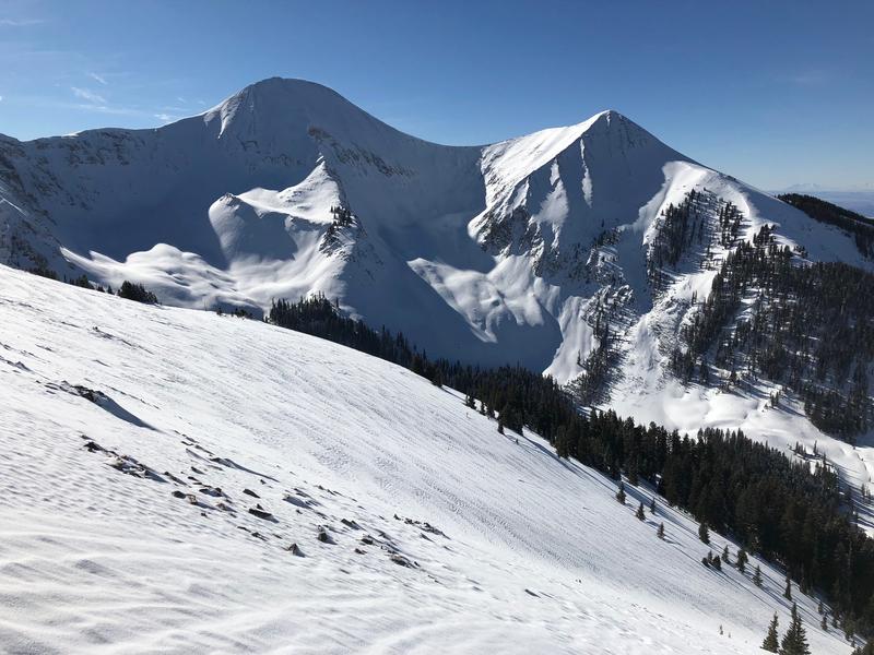
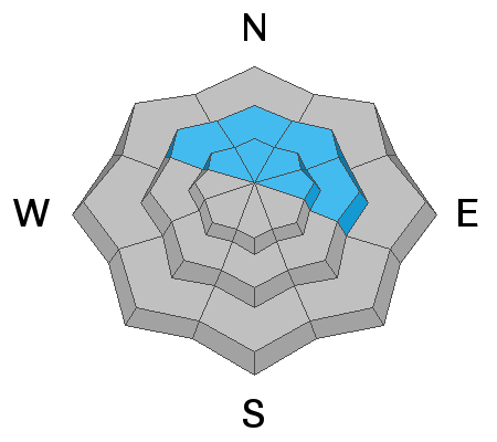
The avalanche danger is MODERATE today for human triggered avalanches involving wind drifted snow. Look for fresh drifts at upper elevations on slopes facing NW-W-SE. Deeper drifts that formed during the Christmas storm are also still a concern. They'll be stubborn, but if triggered, they'll pack a punch. You'll find these older wind drifts on slopes that face N-NE-E. In these same areas there is also an isolated, or MODERATE danger for avalanches stepping down 2'-4' deep into buried, persistent weak layers of loose, sugary, faceted snow. Areas with steep, rocky, and more radical terrain are the most suspect for this type of avalanche.
Low
Moderate
Considerable
High
Extreme
Learn how to read the forecast here
Special Announcements
The new UAC IOS mobile app is now available on the app store. Check out the new "My Weather" feature.
Check out the new free online avalanche course series developed by the Utah Avalanche Center. This is a great way to refresh your skills or prepare you for a Backcountry 101 or Level 1 class.
Weather and Snow
Skies are clear, northwesterly ridge top winds are 10 -15 mph, and 10,000' temperatures are near 20 degrees. The last day of 2019 should be gorgeous for most of the day before clouds move in ahead of the next storm system. Today look for mostly sunny skies, light to moderate NW winds, and high temperatures in the low 20's. Snowfall should start after 10:00 pm tonight and continue into Monday. Up to 6" are possible.
It's been a great week in the La Sal Mountains and the Christmas storm improved conditions dramatically. Above treeline, ENE-NW winds have crusted the snow surface as well as deposited fresh wind drifts, and stiff slabs in odd places. However, yesterday my partner Chris Benson and I found good powder conditions in the alpine just by losing a bit of elevation.
New snow totals in Gold Basin (10,000')
Snow totals at the Geyser Pass Trailhead (9600')
Wind, temperature, and humidity on Pre Laurel Peak (11,700')
National Weather Service point forecast.
It was a gorgeous day up in the mountains yesterday and another one is on tap. Winds have had their way with exposed surfaces at upper elevations but good powder conditions can still be found in more sheltered areas.
Recent Avalanches
I haven't heard of or observed any avalanche activity since Christmas. You can read about the most recent activity here.
Ad
Avalanche Problem #1
Wind Drifted Snow
Type
Location
Likelihood
Size
Description
Slab avalanches involving wind drifted snow remain your primary concern. ENE winds Thu-Fri blew just enough to move snow around at upper elevations, and fresh drifts were formed in odd places on the south and west sides of the compass. They'll be more stable today, but keep an eye out for fresh deposits identified by their smooth rounded, "pillowy" appearance, and look for signs of instability such as cracking in the snow surface. Deeper drifts that formed during the Christmas storm are also still a concern. They'll be stubborn, but if triggered, they'll pack a punch. You'll find these older wind drifts on slopes that face N-E-E
Avalanche Problem #2
Persistent Weak Layer
Type
Location
Likelihood
Size
Description
The most recent snow does not seem to have reactivated persistent weak layers as much I had expected however, the underlying snowpack structure is poor, and I still experienced a few collapses this week. The bottom line is that though it's increasingly unlikely, it's still possible to trigger an avalanche 2'-4' deep breaking down into weak, sugary, faceted snow. The danger is most acute in areas of steep, rocky, north facing terrain that has a weak, sugary, underlying snowpack, and I'm going to continue to avoid those areas.
Additional Information
Grooming info:
Trails were groomed on Friday.
General Announcements
Your information can save lives. If you see anything we should know about, please help us out by submitting snow and avalanche observations HERE. You can also call me at 801-647-8896, or send me an email: [email protected].
Support the UAC through your daily shopping. When you shop at Smith's, or online at REI, Backcountry.com, Patagonia, NRS, Amazon, eBay by clicking on these links, they donate a portion of your purchase to the UAC. If you sell on eBay, you can have your See our Affiliate Page for more details on how you can support the UAC when you shop
This advisory is from the U.S.D.A. Forest Service, which is solely responsible for its content. This advisory describes general avalanche conditions and local variations always occur.