Forecast for the Moab Area Mountains

Eric Trenbeath
Issued by Eric Trenbeath for
Thursday, December 27, 2018
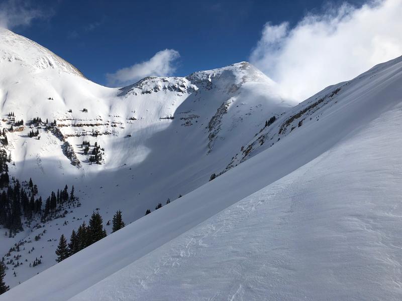
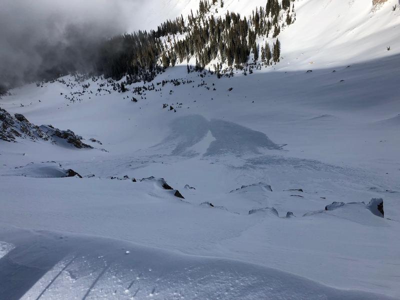
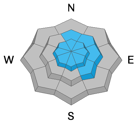
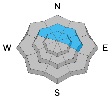
The avalanche danger remains CONSIDERABLE today and human triggered avalanches are likely on steep, wind drifted slopes, primarily at upper elevations that face N-NE-E. In these areas the potential also exists for avalanches to step down 2'-4' deep into buried, persistent weak layers of loose, sugary, faceted snow. Areas with steep, rocky, and more radical terrain are the most suspect for this type of avalanche. Out of the wind zone, the danger is MODERATE but backcountry travelers should avoid any steep slope that shows signs of recently deposited, wind drifted snow.
Low
Moderate
Considerable
High
Extreme
Learn how to read the forecast here
Special Announcements
Grand County will be plowing the road today. The road will be closed while plowing is in progress.
The new UAC IOS mobile app is now available on the app store. Check out the new "My Weather" feature.
Check out the new free online avalanche course series developed by the Utah Avalanche Center. This is a great way to refresh your skills or prepare you for a Backcountry 101 or Level 1 class.
Weather and Snow
It was a beautiful day in the mountains yesterday with fresh snow, light winds, in and out sunshine, and magical cloud play off the peaks. Though not a show stopping dump, 6"-8" of snow has fallen since Christmas Eve and conditions are drastically improved. Overnight, northwesterly winds were mostly calm with a brief bump into the 20's around 9:00 p.m. They are currently light from the north, and 10,000' temps are in the single digits. Today look for increasing clouds ahead of the next system moving into the region. This storm looks to be taking a more southern track but we may squeeze out a couple inches on Friday.
For further information check out the most recent observations here.
New snow totals in Gold Basin (10,000')
Snow totals at the Geyser Pass Trailhead (9600')
Wind, temperature, and humidity on Pre Laurel Peak (11,700')
National Weather Service point forecast.
Don't let the beauty belie the fact that all of this wind drifted snow has created dangerous avalanche conditions!
Recent Avalanches
In our travels up to Pre Laurel Peak yesterday we observed several natural avalanches that had run during the height of the storm Christmas night. Most were loose snow sluffs, or shallow soft slabs of wind drifted snow. In the head of Horse Creek however, we observed two larger avalanches that initiated as wind slabs at the ridge, and that then appeared to step down and widen into older, weak snow further down slope. The area is due north, steep, rocky, and radical, a prime zone for triggering an avalanche on a buried persistent weak layer of sugary, faceted snow. Go here for full details.
Ad
Avalanche Problem #1
Wind Drifted Snow
Type
Location
Likelihood
Size
Description
Slab avalanches involving wind drifted snow remain your primary concern today. Though these drifts will be a bit more stubborn today, they'll still pack a punch and possibly lure you a little further down slope before releasing. Additionally, once moving, wind slab releases have the potential to step down into buried, persistent weak layers. Steep, wind drifted slopes should be avoided today, look for smooth rounded deposits of wind drifted snow and be alert to signs of instability such as whumphing or cracking in the snow surface. The danger being greatest on upper elevation slopes that face N-NE-E.
Avalanche Problem #2
Persistent Weak Layer
Type
Location
Likelihood
Size
Description
The new snow may have reactivated the potential for triggering an avalanche on a buried persistent weak layer more than I expected. Wind drifted snow has added additional weight to the underlying fragile snowpack, and it is possible to trigger an avalanche 2'-4' deep breaking down into weak, sugary, faceted snow. The danger is most acute in areas of steep, rocky, north facing terrain that has a weak, sugary, underlying snowpack.
Additional Information
Grooming info:
Trails are scheduled to be groomed today.
General Announcements
Your information can save lives. If you see anything we should know about, please help us out by submitting snow and avalanche observations HERE. You can also call me at 801-647-8896, or send me an email: [email protected].
Support the UAC through your daily shopping. When you shop at Smith's, or online at REI, Backcountry.com, Patagonia, NRS, Amazon, eBay by clicking on these links, they donate a portion of your purchase to the UAC. If you sell on eBay, you can have your See our Affiliate Page for more details on how you can support the UAC when you shop
This advisory is from the U.S.D.A. Forest Service, which is solely responsible for its content. This advisory describes general avalanche conditions and local variations always occur.