Check Out Our Holiday Auction!

Forecast for the Moab Area Mountains

Eric Trenbeath
Issued by Eric Trenbeath on
Tuesday morning, December 2, 2025
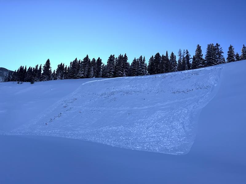
A MODERATE danger exists on steep slopes near and above treeline that face NW-N-NE-E and human triggered, soft slab avalanches, failing on a persistent weak layer are possible. A MODERATE danger exists on these same aspects above treeline for human triggered avalanches involving slabs of wind drifted snow. Even a ride in a small avalanche can be very consequential in low snow conditions.
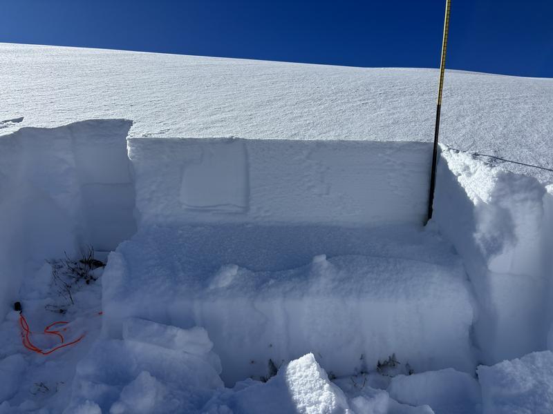
Conditions remain very thin and rocks stumps and logs lurk below the surface everywhere. There still isn't quite enough snow for real turning and riding. Exercise extreme caution getting around.
Low
Moderate
Considerable
High
Extreme
Learn how to read the forecast here
Special Announcements

Geyser Pass Road Conditions: The road has not been plowed and you will find 4-8 inches of new snow on top of the old icy and snow packed surface. 4 wheel drive is required.

It's Avalanche Awareness Week!

Wednesday, December 3 - Don't miss our free Know Before You Go avalanche awareness talk at the Moab Arts and Recreation Center, 111 E 100 N at 5:30 p.m.

Saturday, December 6 - 18th Annual Utah Snow and Avalanche Workshop (USAW). This session will be held in-person at the Wasatch Jr High School Auditorium. 3750 S 3100 E, Salt Lake City, UT 84109. Information and tickets are available here.

Saturday, December 13 - Winter Kick Off Party Bring your skis or board to wax, listen to live music, and bring in another winter season with our local community. Tickets available online now!

Weather and Snow

24 Hour Snow: 0" 72 Hour Snow: 9" Season Total Snow: 20" Depth at Gold Basin: 16"

Winds on Pre-Laurel Peak: 5-10 WNW Temp: 16° F

Weather

A short wave trough dropping down from the north will begin it's descent into the Four Corners Region later today. Look for increasing clouds and the potential for snow starting this afternoon and lasting through tonight. My confidence in this system is low and I'm thinking we'll be lucky to see 2-4 inches but stranger things have happened. High temperatures at 10,000' will be around 20F, and winds will be mostly light and westerly. The rest of the week looks dry with another system affecting points north over the weekend.

General Conditions

Dave and I got up yesterday and it was a glorious day in the mountains befitting the first day of meteorological winter. But belying the fresh snow, sunshine, and cold temperatures, the snowpack remained very thin and travel was a bit treacherous. Overall snow depths range from between 16-24 inches with up to 30 inches in favored locations. On top of that, we already have a developing persistent weak layer problem with recent and wind drifted snow adding stress to pre-existing, weak, faceted snow. We were a bit surprised at the activity we saw including numerous shallow avalanches on road cuts and at least one slide large enough to bury a person. For more details see Dave's observation. Ryan Huels was also up yesterday and submitted this excellent observation.

For more on what we found up there yesterday, see the video below.

Snowpack and Weather Data

NEW! Gold Basin webcam storm stake

Gold Basin Storm Stake (10,000')

Gold Basin SNOTEL site (10,000')
SNOTEL site near Geyser Pass Winter Trailhead (9600')
Wind Station on Pre-Laurel Peak (11,400')
NWS forecast for the La Sal Mountains.
Recent Avalanches
In our travels yesterday we came across this R2 D2 avalanche in Colorado Bowl. Definitely large enough to bury a person.
Avalanche Problem #1
Persistent Weak Layer
Type
Location
Likelihood
Size
Description

A very soft slab now sits over top of pre-existing, weak, faceted snow. In many areas, the slab lacks enough cohesion to produce an avalanche but in areas where it is cohesive, avalanches deep enough to bury a person are possible. The most likely areas to find a cohesive slab are where the snow has been thickened by the wind but over time, the most recent snow will consolidate into a denser, more widespread slab. In some areas, shallow slabs are failing on weak facets at the old snow surface, while in at least one case, an avalanche failed on facets all the way down to the ground. The unfortunate thing is that these avalanches are most likely on slopes that have the most snow and where you are most likely to try and ski or ride. Any avalanche triggered right now would be a very rough ride to say the least, and it could possibly even bury you.

The photo below, submitted by Ryan Huels, illustrates the results of an extended column test (ECTP 16) with a soft slab failure on facets at the old snow surface.

Avalanche Problem #2
Wind Drifted Snow
Type
Location
Likelihood
Size
Description
Areas of unstable wind drifted snow exist on slopes facing NW-N-NE-E primarily above tree line. These are recognizable by their smooth, rounded, or even wave-like appearance. Wind drifted snow generally stabilizes after a few days, but in our current case, they have also added additional stress to our persistent weak layer problem. For this reason, all steep, wind drifted slopes should be avoided for the foreseeable future.
Additional Information

It's never too early to start thinking about avalanches. Here are a few things to consider doing:

  • Learn online. We have over 5 hours of free online learning at the Know Before You Go website
  • Check out the upcoming in-person Know Before You Go events HERE
  • Sign up for an on-snow class
  • Check out the UAC's education progression HERE
  • Get your avalanche rescue gear ready for winter. Put fresh batteries in your transceiver and update the firmware. Inspect your shovel and probe. Get your airbag backpack ready by possibly doing a test deployment and updating the firmware if it is an electric version or getting your canister refilled if it's not electronic.
General Announcements
This forecast is from the U.S.D.A. Forest Service, which is solely responsible for its content. This forecast describes general avalanche conditions and local variations always occur.