Check Out Our Holiday Auction!

Forecast for the Moab Area Mountains

Eric Trenbeath
Issued by Eric Trenbeath on
Monday morning, December 1, 2025
An isolated or MODERATE avalanche danger exists on steep slopes near and above treeline that face N-NE-E and human triggered soft slab avalanches are possible. In these areas, recent deposits of new and wind drifted snow have accumulated on top of pre-existing, sugary, faceted snow. Overall coverage remains quite thin and the avalanche danger is isolated to areas with the deepest and most continuous snow cover. Avoid fetch areas such as gullies and depressions that have recent deposits of wind drifted snow. Even a ride in a small avalanche can be very consequential in low snow conditions.
Low
Moderate
Considerable
High
Extreme
Learn how to read the forecast here
Special Announcements

It's Avalanche Awareness Week!

Wednesday, December 3 - Don't miss our free Know Before You Go avalanche awareness talk at the Moab Arts and Recreation Center, 111 E 100 N at 5:30 p.m.

Saturday, December 6 - 18th Annual Utah Snow and Avalanche Workshop (USAW). This session will be held in-person at the Wasatch Jr High School Auditorium. 3750 S 3100 E, Salt Lake City, UT 84109. Information and tickets are available here.

Saturday, December 13 - Winter Kick Off Party Bring your skis or board to wax, listen to live music, and bring in another winter season with our local community. Tickets available online now!

Weather and Snow

24 Hour Snow: 9" 72 Hour Snow: 9" Season Total Snow: 20" Depth at Gold Basin: 18"

Winds on Pre-Laurel Peak: 15-20 NNW Temp: 9° F

Weather

Some call me a pessimist but I'd rather be pleasantly surprised than greatly disappointed! At the end of the day, the storm produced 9 inches of snow at 0.9 inches of Snow Water Equivalent (SWE), your standard 10% density powder snow. I expect we could have a foot or more of new snow up high. Pre-frontal southwest winds cranked in the 25-35 mph range but backed off a solid 10 mph when the snow started to fall. They shifted to the northwest around dinner time last night where they remain this morning.

Cold and clear conditions are on tap today with light to moderate northwest winds and high temperatures at 10,000' barely breaking 20F. Clouds will again start to build on Tuesday ahead of the next system to affect our area Tuesday night into Wednesday. It looks similar to the last event, keep your fingers crossed.

General Conditions

This was a welcome shot of snow but cover remains thin with about 18 inches on the ground at 10,000' and probably close to 30 inches as you approach 11,000' and above. In my book, it's still not quite enough for off-trail skiing and riding. There are a few grassy slopes and meadows where you can probably pull it off otherwise, areas that have enough snow are also where you are most likely to find an avalanche. Field work performed last week indicated that the pre-existing snow was beginning to facet and weaken, especially near the surface, and we've now put a decent amount of new snow on top. We'll get up today to see how it's behaving but in the meantime, check out Dave's video below where he describes conditions prior to the storm.

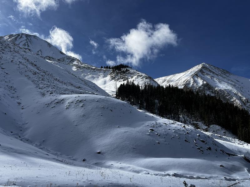
Conditions prior to the storm were quite thin as evidenced in the photo below. Note the areas of contiguous snow with the least amount of rocks poking out. This is the kind of terrain where you are most likely to trigger an avalanche.

Snowpack and Weather Data
Gold Basin SNOTEL site (10,000')
SNOTEL site near Geyser Pass Winter Trailhead (9600')
Wind Station on Pre-Laurel Peak (11,400')
NWS forecast for the La Sal Mountains.
Avalanche Problem #1
New Snow
Type
Location
Likelihood
Size
Description

With 9-12 inches of new snow falling on top of pre-existing, weak, faceted snow, we've developed our first avalanche problem. For now, expect avalanches to be confined to the new snow, particularly in areas where wind has aided in the distribution. Suspect steep slopes with an accumulated 8 inches or more of new snow. Also pay attention to loading patterns and look for drifted areas such as the leeward sides of ridge crests, gully walls, and other terrain features. Over time, this new snow will stiffen and consolidate forming a more widespread slab. With weak faceted snow underneath, this will likely turn into a persistent weak layer problem, especially when more snow is added mid-week. Stay tuned.

Additional Information

It's never too early to start thinking about avalanches. Here are a few things to consider doing:

  • Learn online. We have over 5 hours of free online learning at the Know Before You Go website
  • Check out the upcoming in-person Know Before You Go events HERE
  • Sign up for an on-snow class
  • Check out the UAC's education progression HERE
  • Get your avalanche rescue gear ready for winter. Put fresh batteries in your transceiver and update the firmware. Inspect your shovel and probe. Get your airbag backpack ready by possibly doing a test deployment and updating the firmware if it is an electric version or getting your canister refilled if it's not electronic.
General Announcements
This forecast is from the U.S.D.A. Forest Service, which is solely responsible for its content. This forecast describes general avalanche conditions and local variations always occur.